22 Miles Over the Tetons: Jenny Lake, Hurricane Pass, and Alaska Basin (Kind Of)
This is an incredible day hike for folks who are in shape, though probably best done when the weather is cool. (Status: not proofread.)
➻ Quick Facts
Info at a Glance
- Date of Visit: October-no-kidding-9th!
- Notable Features: Jenny Lake, Hidden Falls, Inspiration Point, Cascade Canyon, Teewinot Mountain, McCain’s Pillar, Mount Owen, Grand Teton, Middle Teton, the Cathedral Group, Cascade Creek, South Fork Cascade Creek, Table Mountain, Schoolroom Glacier, Hurricane Pass, Sunset Lake, Alaska Basin, South Fork Teton Creek, Teton Canyon Campground
- Total Miles: ~22.2
- Elevation Gain/Loss: +5098/-4967
- Elevation Min, Avg, Max: 6790, 8194, 10540
- General Route: Jenny Lake Loop Trail, Inspiration Point Trail, Cascade Canyon Trail, South Fork Cascade Canyon Trail, Schoolroom Glacier Spur Trail, Trail 6008A Teton Crest Trail, Unnamed Spur Trail 1, Unnamed Spur Trail 2, Trail 6027 Alaska Basin Trail
- GaiaGPS Page for GPS Track Download Grab a free Gaia account to download the GPS file for your phone or Google Earth. (Under “Data.”)
Interactive GPS Map (Click to See)
Elevation Profile

⤷Introduction
My mom and I don’t get to hike too much together, so I had been wanting to go on a hike with her in the fall. The week leading up to October 9th I had received a new employee and gotten some sort of mystery illness that had really done a number on me: 103-degree fever for a few days, the feeling that my head might explode, and a cough that was as terrible as it was unproductive. The bad news was that the weather was shaping up to be great at the end of the week, so I told my mom to head on up, stay at my house on Saturday, and join me for a quick hike over the Tetons on Sunday. My wife would be returning from Idaho Falls and would be able to pick us up below Grand Targhee, and if we started at Jenny Lake, we could take the South Fork Cascade Creek Trail, which we’d previously only seen from Paintbrush Pass. Mom thought it sounded fun, though she was worried about my health. Hey, it’s better than “died unexpectedly at home,” which people in my age bracket in my little hometown had developed a distinct proclivity for doing. Absolutely tragic.

⤑A Day Hike from East to West Across the Tetons
Mom and I got up very early and made our way to Jenny Lake Trailhead, hoping to arrive with the dawn. The shortening days had brought with them a reduction in thermal mass, meaning that the ground and air were very chilly in the early mornings. As such, we didn’t really feel like hiking in the dark.
We arrived at 0724 and got out of the car to temperatures appreciably below freezing, which made utilizing the privy at the trailhead unpleasant. After leaving the trailhead, we stopped at the bridge by Jenny Lake and took a bunch of pictures. The fall colors were phenomenal, and my crappy photos can’t do the scene justice. I was personally amused that the Helly Hansen down jacket I’d gotten mom was really camo for this time of year. We left at 0744 and an older couple stopped at the bridge to get photos as we had. We had both taken only our day packs, and mine was very light, with my Canon, an extra lens, some jerky and other trail food, a battery pack, and of course our Sawyer filtering supplies. Mom’s was basically empty at this point, and she’d only brought it to store her gloves, hat, and coat.


The trail around Jenny Lake is easy and pleasant enough, though also boring to a degree that makes the ferry a worthwhile expense during its running season.
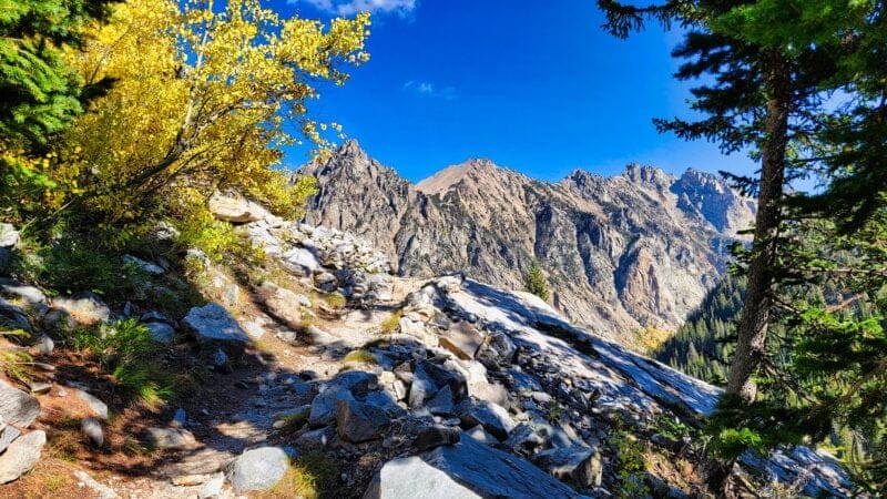
As we tromped along it slowly got warmer; we passed a slower, larger couple who seemed a bit bushed (we were impressed at their willingness to be out burning the calories at such a time in the morning) for only being about 1/2 mile in, and then began the climb up to the overlook trail, which avoids some of the ups-and-downs closer to the shore in favor of remaining around 300′ higher than the lake. Because the trail doesn’t really lose that elevation, it’s worth taking in my opinion.


Towards the top it had warmed up enough that we stopped and put on some of my homemade anti-chafing cream. I took off my coat, but mom kept hers on. I always dislike when it’s freezing in the shadows and baking in the sun, and it seemed that it would be so for a while. As we approached the rockpiles (well engineered) the sun starting getting to mom, so she took off her coat and stowed it. I laughed and sent myself into a coughing fit. The little cloud over the lake was at least beautiful!


We arrived at the Hidden Falls trail intersection at 0849 and I made some dumb comments about a prank wherein a sign in the style of the National Park ones would be placed in the area warning against flash photography so as not to disturb the native fish. Mom was not amused, which is really the correct reaction, but I do think that my fever-addled mind produces some rather unique dumb ideas. I mean dumb, yes, but also pretty rare, and perhaps in that way still of interest. Turns out that mom doesn’t agree.


After crossing the bridge we climbed the switchbacks to Inspiration Point and then enjoyed the relatively flat section of the journey, which, if you’re unaware, is also quite scenic. It’s no Central Park, and it can’t hold a candle to the Riverwalk in San Antonio, but it’s decent enough. We stopped where the river first comes close to the trail and filled up with water, which was a bone-chilling experience for the fingers. Although thirsty, the temperature of the water was rather unpleasant. As we filled up, two separate sets of couples passed us.


The trail remains relatively flat until about 6.3 miles in and we found ourselves making great time even with all the picture taking. The lighting was really very decent for the time of day.


We entered the forest just before the beginning of the trail’s steeper ascent and encountered a group of people stopped and point at something. I videoed the something…or somethings. Turns out it was a group of moose. When I realized that we quickly left the other folks behind and zipped up the hill and away from the critters.


Just prior to the trail splitting to Solitude Lake a mom, father, and kid passed us going downhill. The kid was maybe 7 years old. As soon as they got downhill of us I recognized that they were a local family who had emailed me some information previously. Specifically, they’d read one of my posts about another mountain range and done the trip themselves with their then 5 year-old kid. The family dynamics were unique and I was bummed that I hadn’t recognized them in time to stop and introduce myself. Still, it was a blessing to see them out camping!
At 1100 we began the long trek up toward Hurricane Pass, stopping to get water at 8100 feet but otherwise keeping a relatively steady pace. The views are pretty nice though not truly spectacular until the Schoolroom Glacier area. A couple of major switchbacks just below 8500 feet provide some real depth, but once you’re beyond them it’s relatively mundane uphill travel through intermittent forests. We didn’t stop again until mile 9, right at 9000 feet, where a small creek crossed the trail and provided a good opportunity to get water. We consumed some of my homemade jerky and not-so-homemade chips. As is her wont, mom ate nuts. I find them a heavy snack to carry. Anyway, the area reminds me of the Sierra Nevadas. Tom Woods kept our minds off the climb thanks to a very interesting interview with Gerard Casey, professor emeritus of philosophy at University College, Dublin, who joined him to discuss the transgender movement, which has ossified into orthodoxy in record time.


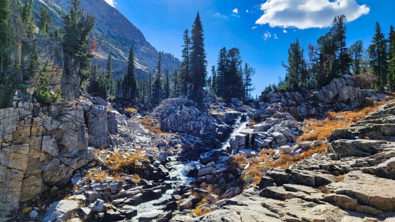


Beyond some more switchbacks at 9400 feet we broke out into a flat area where we shortly had an opportunity to take the trail over toward Kit Lake and Avalanche Divide. I’d like to do that one day, but today we didn’t have time for the extra 5 miles or whatever it is. Rather we took a large switchback and then went up an improbable gully, entering a final flat section just before Schoolroom Glacier. A use-trail leads to the associated glacial lake, and we stopped by to check it out. It was truly remarkable.


A quick jaunt 300 feet up along the trail brought us to the use trail to the glacier. Coming down the mountain was a marvelous woman made entirely of vigor and muscle and topped with a massive dashing of good cheer. Oh, and she was DASHING down the switchbacks, but slammed on the brakes and skidded to a halt to tell us, with the largest smile I’ve ever seen, what a grand day it was, that she couldn’t believe the weather, and that it was lovely to see us. I tried to avoid my horrible, wet, hacking cough, as well as any feelings of resentment due to the absolute Spartan nature of this beast. She really was fun and memorable. Before she departed she told us that we might encounter some other folks behind her and that I was to tell them, “She went running down the trail and will meet you later! YOU CAN DO IT!” Then the gal bounded off.
Mom and I made our way to the glacier. As long as you have legs that aren’t broken, the very brief walk there is pretty easy, and the views are worth it. We took a number of pictures and and I saw a plane circling piloted by a man who has caused some amount of trouble with his piloting “technique.” Also circling the Grand was a Cessna I recognized as being from Driggs. As we took photos, we saw the lollygaggers that the running gal had mentioned, but they were too far away for us to interact with.


As you can see in the photos above, at this point we were right at the lip of the pass, so we bounded up and…mom got cell service and started working. Terrible, terrible mother! Thankfully she was done quickly enough and ready to examine the landscape. I pointed out Grand Targhee (my kid LOVES Screaming Cheetah) and some other features, then we took the sharp left toward Alaska Basin. It really is evident from the top of the pass just how small this little island range is.


A short climb brought us to our high point for the hike where we met a young man who said he was about to do the hike down and had stayed the night in Alaska Basin. He said he was happy to soon be heading downhill. SO SAY WE ALL!
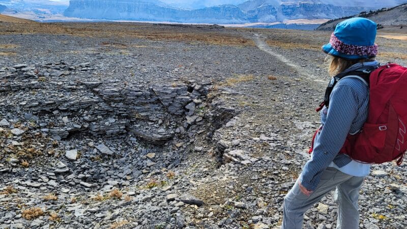
Hiking from Hurricane Pass toward Alaska Basin is beautiful if barren, taking one through a massive, treeless area filled with Karst topography. We reached a set of switchbacks just under a mile from the actual pass and had a great view of Sunset Lake. The trail zig and zagged toward Sunset Lake, avoiding a direct line in favor of less ups and downs. We were surprised to see no one there.


Along the way to Sunset we were surprised to find another source of water as a creek came tumbling down, and upon reaching the lake we had to decide if we wanted to go all the way into Alaska Basin proper or head downhill toward our terminus. The day was wearing on so we decided that we’d head toward the trailhead, especially as we weren’t certain when my esposa would pick us up. We’d said 7PM and didn’t want to be too late. Mom and I had listened to some tabletop gaming podcasts and started listening to, IIRC, Blue Peg, Pink Peg. I love Tom Vasel, The Dice Tower, The Secret Cabal, and Dads on a Map, but I found BPPP to be…ugh. I can’t describe how off-putting the show was, and I furthermore even to this day cannot articulate why. Keep in mind that the majority of humanity rightly feels that I am an off-putting, nigh-feral monster, so perhaps they’re really great people. Still, not for me.


Heading downhill from sunset lake, mom went north to pee and we ended up on opposite sides of the creek. She somehow then got a little bit lost and I have to head back uphill to find her. Apparently she’d found some sort of trail heading toward the canyon we were going to exit via, but not the right trail. My map showed two trails in parallel heading downhill from the lake, and we tried to stick to one of them. Until about 9400′ there was really no definite path, but rather bent, dry grasses, minor cairns, and some other intermittent signs that others had done the same as we were attempting.


Below 9400′ somehow a trail developed into an incredibly apparent feature. We made our way down along a ridge and took a major switchback at 9200′. Don’t let Google Earth fool you, because this was a very steep descent and scrabbly too.


We connected with the Alaska Basin trail which was very well engineered and started the haul out. We had 6 miles to go and it was about 5:15, leaving us an an hour and 45 minutes to get to the trailhead. Doable, by my knee hurt. To alleviate the pain we put on Mike Rowe’s (what a wonderful guy) podcast, “The Way I Heard It.” We’d listen to it the entire rest of the journey out.
The area where we connected to the main trail reminded me very much of being near Spaulding Lake (between Reno and SFO), with large, granite boulders and similar trees. The evening sun filtered through the atmosphere and provided a warm, burning hue to the rocks in places—sadly, my camera entirely failed to capture that. Mom and I were both surprised that the temperatures were as pleasant as they were, though the pace we were maintaining probably helped.


I would say that the scenery was best before we descended below 8500 feet (some notable switchbacks are there), but even below that it was still nice, though lacking the Sierra Nevada feel. The lower you go, the bigger Teton Creek gets, so there’s a definite shift in how the landscape feels. For us, descending into the setting sun, seeing higher, yellow aspens set aglow while the canyon sank into deep, chilly shadows, the experience was very peaceful. Had we been hitting an average of 3.4mph past mile 18 with the sun directly overhead in July, I’m sure we’d not have been so fond of the experience. Despite the knee pain and our average egress speed, my heart rate remained low. Not bad for coughing up bits of lung every 67 seconds, eh?


We passed the junction with Devil’s Staircase at 6:25. The sign claimed that we had 2.7 miles to go and it was getting pretty dark. Since we wanted to be at the campground/trailhead at 7PM, we really needed to get our move on. Thankfully for us, beyond Devil’s Staircase, the trail becomes very flat and straight, going through a long field for quite some time. We jogged this section of the trail. Although my map showed another trail going up by table mountain, we were never able to spot it. Perhaps it is disused. The trail from the actual trailhead is notably present.


The last section of our hike took us into the woods which were becoming quite dark. We didn’t need to use them yet, but I felt bad that we were running late. Finally we emerged at the trailhead 14 minutes behind schedule. Oof! A large truck was there along with a woman, man, and dog, but no sign of my wife and child. We hoped they were ok. We decided to walk down the road and see if she’d stopped at the wrong spot.


As we left, night officially came, and we put on our headlamps. My wife was nowhere to be found, and of course the “oh no” scenarios started cropping up in my mind. I sent a satcom message but got no reply.
Then, at almost 1940, car lights appeared. It was her! As it turned out, she’d gotten confused and for some reason driven up to Grand Targhee, realized she was at the ski resort, and had to drive all the way back down and then up the road. I was just relieved that they were safe!


➤Conclusion and Rating
An absolutely fantastic hike that I wouldn’t want to do during peak season when the crowds are seething and the temperatures high. For a fair-weather, late fall day hike, it was a total blast.
- My scientific rating system. I absolutely loved this hike.
- Beauty. They’re a small range, but they’ll do.
- Camping spots. Special restrictions apply for backcountry campers.
- Crowds. Typically packed, but none at this time of year.
- Difficulty. Strenuous as a day hike. We were in shape, so it wasn’t bad and didn’t leave us sore, but don’t kid yourself if you’re coming from low elevation and haven’t been exercising.
