Review: 26 Fall Miles Hiking Big Sandy, Shadow Lake, Texas Pass, and the Cirque of the Towers
Although a really nice hike, I’d probably only do this in fall to minimize the awful crowds. (Status: not proofread.)
➻ Quick Facts
Info at a Glance
- Time of Year: 25 September
- Notable Features: Big Sandy Creek, Meeks Cabin Lake, Fish Creek Park, Mirror Lake, Dads Lake, Marms Lake, Washakie Park, Shadow Lake, Billys Lake, Barren Lake, Texas Lake, Texas Pass, Secluded Lake, Lonesome Lake, Cirque of the Towers, Jackass Pass, Arrowhead Lake, North Lake, Big Sandy Lake.
- Total Miles: ~25-27
- Elevation Gain/Loss: +/-5241
- Elevation Min, Avg, Max: 9092, 10048, 11444
- General Route: Trail 7096 Continental Divide Trail, Fish Creek Park Trail, Trail 7096 Continental Divide Trail again, Hailey Pass Trail 7111, Shadow Lake Trail 7149, Trails around Lonesome Lake, Climbers’ Trail, Big Sandy Trail 7099
- GPS Track Grab a free Gaia account to download the GPS file for your phone or Google Earth.
Interactive GPS Map
Elevation Profile

⤷Introduction
The weather was calling for perfect fall conditions and my wife encouraged me to get another hike in if I could. I was running out of new places to hike, but I’d have plenty of time to do a quick loop hike from Big Sandy to Shadow Lake, Texas Pass, and back out. I hadn’t done Texas Pass before, so I was intrigued by the opportunity.
We decided to rent a room in Pinedale on Friday so that my wife and kid could go early (they had the day off) and have fun, then spend the night together. I’d leave early on Saturday morning and be out Sunday evening, making for a 25-27 mile overnight hike. We stayed at the Pinedale Hotel and Suites which we find to be better than the Hampton: comfier beds, nicer people, and a much better pool. I don’t eat breakfast, so I can’t comment on that, but my wife and kid say it’s fine.


⤑Day 1: Big Sandy Trailhead to Billys Lake
Friday night wasn’t pleasant for me as my kid kicked and punched me in her sleep all night long. I ended up sleeping about 4 hours and 50 minutes. Blah. With that in mind, I got up well before daybreak and headed out. My wife had gotten me a sandwich from the store to eat on my way to the trailhead, though she’d neglected to get any condiments.
As I drove to the trailhead (such a long drive from Pinedale to Boulder, from pavement to dirt) I ate the very dry sandwich and sipped on an energy drink to help me wake up. Slowly the sun came up. I didn’t see many people, a blessing provided by the late time of year. After the sun rose, the temperature hovered around 25F, so I knew it would probably be a bit chilly at first. I planned to hike in speedy fashion for a while to counteract it.


I arrived at the trailhead at 0846 and went to use the privy. There weren’t too many vehicles at the trailhead (35 or so), but there were two other people groggily stumbling about. I blasted off from the sleepy people less than 10 minutes after arriving and elected not to wear my jacket, instead keeping a decent pace. My pack was relatively heavy for an overnighter as I had cold weather clothing and a down sheet to go with my REI Magma 10. I’d also brought my Canon with a brand new lens. More on that later.
Since I’ve hiked this area numerous times and have a decent number of details already included in other reports, I’m not going to inundate this post with too many details about the trail prior to Washakie Park. I swiftly made my way toward the divergence toward Fish Creek Park and passed an older couple only a few minutes into the hike. Within 7 minutes of leaving the trailhead I had started the 900′ ascent toward Fish Creek Park. I passed a couple of hunters near Meeks Lake. They were friendly and asked me how long I was staying out. I told them that sadly it was just an overnight for me thanks to work. We said goodbyes and I kept going.
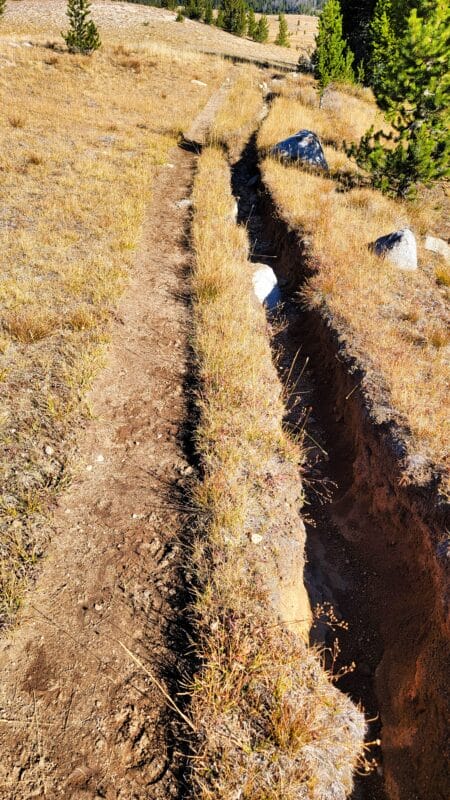
Although the fall colors were nice, what was really incredible was the massive blowdown from the windstorm that occurred when I was working overseas during the pandemic. Traveling offtrail in some areas would just be awful. I had considered hitting up Blue Lake and adding some miles to finally do Fish Creek Pass/Fish Lake Pass by Laturio Mountain, but with that sort of blowdown it didn’t seem wise. In fact, such a level of blowdown really changed a number of my plans for this area of the winds effectively for the duration of my life on this earth. Right before the high point along the trail (before going back down the small dip to Fish Creek Park), I passed a couple of young gals in their 20s along with their dog. I couldn’t tell if they were heading in or going out, and they didn’t seem at all to want to talk with me, so I zipped by with a quick hello and pressed on, reaching the top just an hour after leaving the trailhead.


Fish Creek was icy as I hopped over it, and the shadows still clutched the cold greedily. I felt warm myself and made sure that I was wearing my hat and sunblock. I reached Dads Lake an hour and 45 minutes after leaving the trailhead and stopped at the prominent creek crossing midway along the lake. Although the water was insanely cold, I needed to drink, so I filled up my Sawyer bladder and drank almost the entire gallon, along with some berry-flavored Propel. The experience was intensely cold and took about 30 minutes, giving me time to have a light snack.


With watering out of the way, I resumed a quick clip to Marms Lake, arriving just before noon. This put me a bit ahead of schedule timewise. The last time I had been here I had been accosted by a marmot along the shore, but this time I only saw a late-season caterpillar. While I was interested in checking out the lakes to the east of Marms, I wasn’t about t get into the blowdown. Reaching the northern side of the lake, I took the eastern trail which I’d never used before. It led me to a long gully/ravine that was a bit…dusty. Kind of rocky, too. The gradient wasn’t bad, and since I was doing so well on time, I stopped at the top and rested in the shade. It was actually warm now, so the shade felt good. I had a nice lunch and listened to some tabletop gaming podcasts to pass the time.


After lunch I continued on through a large, flat, pleasant meadow (with views looking toward the parallel trail and a spot I had previously camped with my mom, as seen in the picture below with the blue highlight). In the distance was Washakie Pass. My mom, Hank, and Peggy had all hiked that area, but was still on my list; I guess it’s good to keep something to look forward to in reserve. I got to the Shadow Lake Trail at 1PM. It wasn’t a land speed record, but I’d effectively traveled 9 miles in 4 hours, with about an hour spent completely stopped watering or relaxing. Decent enough in my book, especially given that my right knee was in pain. Ever since the Elkhart Park-Green River Lakes trip in 2015, where I’d twisted the knee something fierce, my right knee has been prone to acting up.
Below: The blue area is where we camped using the other trail. Then there’s the field leading to the intersection.


Brain surgeon Bruce Geryk and rascal Tom Chick kept me company as I began the mild, 650′ climb from Washakie Park toward Billys Lake. Tom had once invited Bruce to play “Paleolithic” with him, and Bruce had chuckled and chortled the whole time, then completely crushed Tom. As they explained, this game actually has a “best method” to play which will ensure victory every time, and Tom hadn’t known that, but Bruce had. Some tabletop games are like that, where they can have an absolute best manner of play. Others, like Wingspan, have some good tactics which can be employed, but at the same time have (in my opinion) too much luck involved. Give me Terraforming Mars or Dune with the Rise of Ix expansion any day.
The trail is mostly flat and goes through a field for about a mile past the intersection, then crosses Washakie Creek. A tall, lean man with grey hair passed me about 1000′ before the crossing, cordially inquiring if I loved the weather as much as he! Surely I did!


This late in the year the crossing was easy and didn’t require the removal of shoes or the propping up of oneself with magic sticks, which I do not carry, and which my trekking pole friends of course do, waving them in my face and telling me that I’m destroying my knees. Little do they know that I was raised by a feral pack of dingo dogs and find myself quite happy scuttling about sans walking aids.
On the other side of the creek I stopped to take some pictures with my new lens, a Canon 15-85, which I thought might be nice for walkabouts. After taking a few pictures I reviewed them and found that one edge looked soft. I took a few more…same. I inspected the lens and it looked fine, inside and out. A few more shots confirmed my worst fear: the lens had exceptional decentering. Effectively I was carrying around a massive paperweight. Blah. As I pondered my fate, James Lindsay talked in an interview with Michael Malice about how he’d been kicked off twitter. (If that dates the hike at all.) His lamentation was not enough to cheer me up about the state of the camera, now useless. No star shots this night, I realized. No evening shots…just my phone. (Note: Amazon kindly replaced the lens with no questions asked, though I pointed out the decentering.)
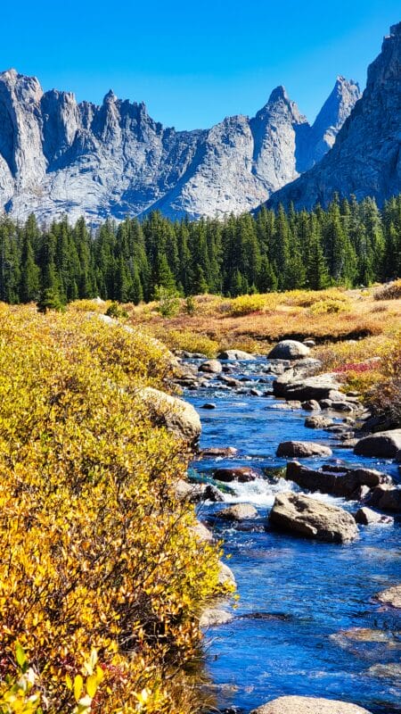
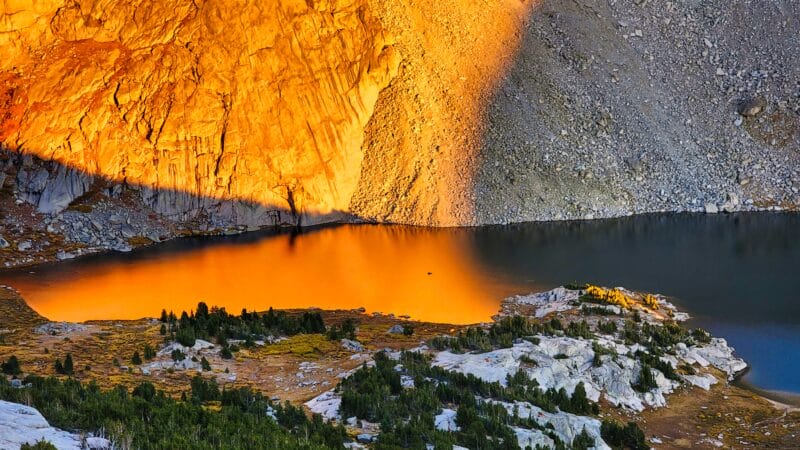
As I headed up toward Shadow and Billy Lake I was pretty happy with the view. The Backside of the Cirque is truly magnificent as one approaches Shadow Lake, with intimidating spires and at this time of year, an amazing combination of fluorescent yellows and oranges on the ground, dark green spruces above, towered above by granite-grey gendarmes, and capped with dark, fall-blue skies. It was truly mesmerizing.


Around 10200 the trail began to parallel a small stream that was not Washakie Creek, though perhaps a sibling or close relative. I hopped it with no problem, but I imagine in early summer the area is quite marshy and tedious to travel. After entering forest for about 1000 feet, I leveled off in an area that is obviously marsh during much of the year. There were diverging trails, with one going toward Billys Lake and the other toward Shadow. What sort of monster would bypass Shadow Lake when the trail adds at most 1/2 a mile if one’s going up to Billys? As a known and reviled monster myself, even I was repulsed by the idea of bypassing Shadow Lake, so I didn’t, and instead went to explore the thing.


The lake is almost as pretty as my wife. I tried fishing for a few casts but to no avail, so I instead picked a bunch of swamp blueberries. They weren’t the best, but not the worst. I found great camping spots all around and found myself stricken with anxiety: should I go on up to Billys? Would it be prettier? Surely not. But what if it was? But what if I couldn’t find a good campsite there, since I knew it had less trees? I wrestled with the idea for a bit, but eventually put my backpack back on and decided to make my way up.
Below: In the first picture, the slot going up and to the right is what I believe to be the climbers’ route. The other pictures are just walking about the lakeside. Now you know why I wanted to camp there so bad. I had fears that I’d be surrounded by plenty of others though.


The trails around the lake somewhat come and go, passing over little creeks and in and out of the woods, joining together quickly to just as soon split apart. My map had a general trail on it, but let’s be honest, sometimes it’s better to just let instinct take over and compel your feet. I found myself slowly making my way uphill, past intermittent, massive boulders, and progressively getting close to Washakie Creek between the two lakes.
As I made my way up, I looked for a shortcut trail into the Cirque that was on my map. It lets one avoid Texas Pass, but for the life of me I couldn’t see it. I had read online one person saying that it’s not really made for carrying a pack up, so I think it might be for climbers only. I’ll attach a picture of where I believe it to be. If I’m right, it’s really just a vertical death-ascent over loose scree that could see you die from a tumble. I saw a use trail heading that way, but there were also many use trails…it was hard to tell for certain.
Below: I think that the scree crack is the climbers’ route. Not certain.


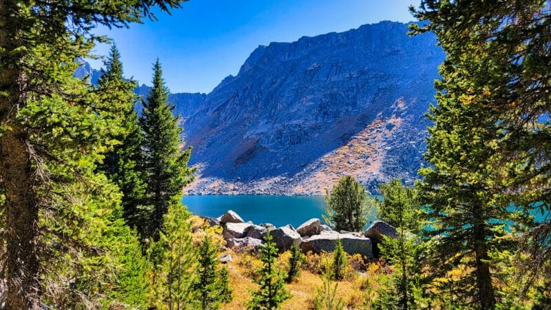
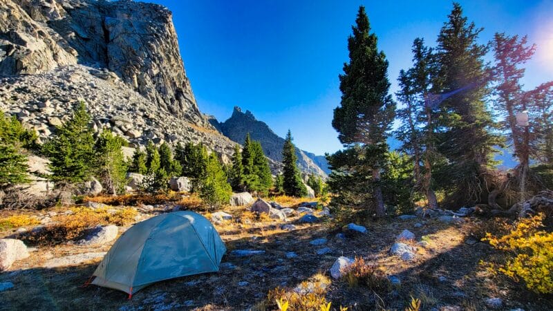
Billys Lake is only about 300 feet above Shadow and I arrived there at 3PM. It wasn’t as scenic as Shadow Lake, but it was quite pretty in its own way. Going back down to Shadow Lake certainly wasn’t worth it. I could see the main trail off to the north, so I crossed the creek to the south and climbed a little hill near the outlet. There I found a number of great spots to camp. They weren’t in the trees, but they were far from enough from the water, gave me a nice view, and were hidden from (and not close to) passersby.


Having arrived, I circled the area like a dog trying to find the best way to bed down, which most of my exes would say is a rather apt description. Once I found a choice spot and cleared it of sharp stones and debris, I went and collected massive amounts of water from the lake. There were spots where I could walk out on rocks and dip deeply into the lake, making getting the water easy. I gravity filtered a full pot and a couple of pouches there, drank one pouch, re-filled it, and then collected a last gallon to take up to the tent area.
With the water out of the way, I set up the tent, found the meal I’d eat later, hung the bear bag, got my bed made, and then collected dead wood for a fire later that night. A man passed by on the trail in the distance, but he didn’t stop. Unfortunately, about 30 minutes later 3 people passed by and did stop. What luck, huh? Guess I should have stayed at Shadow. They didn’t see me and parked it by the lake on the other side of the creek. Thankfully they were quiet.
Below: My aging tent has spots. Do you know why? Also, you can’t see it well in these pictures, but Washakie Creek between Billys and Barren has an awesome waterfall much like the famous one in the CotT.


With everything set up to my liking, it was only 5PM. While it would be dark soon enough, I prefer to read and watch videos after dark. I decided that I’d climb a little way up Bair Peak to take a look at the lakes from above. I crossed the outlet of the creek and passed by the tents of the 3 people; they seemed to be quietly in repose in their respective tents, so I made haste quietly so as not to disturb them. Making my way across the flat meadow to the north, I tried to ascertain the best path upward. A main gully had too many bushes to make easy travel, so I stuck further west, although not on the granite spine of the ridge. It was pretty dang steep in some areas, but 25 minutes of walking (my knee didn’t like it) brought me to a nice overlook at 11,444′. I considered climbing further, but part of me wanted to save the first look into Washakie for when I actually took the pass, so I decided to save it. Besides, it was 5:40 by this point, and the 800′ climb had yielded some great views.
Below: The climb to the side of Blair to the bench. If you look through all the pictures, you’ll see my tent, the tents of the interlopers (tenterlopers?), and in the last set of pictures, a saddle looking into the Cirque. I ended up finding out that the saddle would be navigable, but probably not a timesaver or worth the effort.


I had my phone with me and found that I had some cell service. I made a video message for my old friend and blasted it out, then did the same for my other friends and family. I prefer to do this when I’m able as it saves my satcom data, and saved satcom data means I can do more pin drops. My mom was VERY jealous when I sent her a picture. Some time ago my daughter had written the sweetest note. I keep it in my phone and send pictures of me with it to her when she can’t be with me. This made her night, and of course I got to talk with her, too.


Because I wanted to see the sunset, I waited for an hour at the little bench on the side of Bair Peak, got some sunset photos (they came out looking unreal, unfortunately), then made my descent back down to my tent, this time taking the granite ridge for a time.
Below: My photos didn’t come out very good. I tried to use my Canon and crop out the decentering, which was a small fail. You can see in the last photo where my tent is. I prefer tents which are hard to spot, but I keep bright colored items in case I need to be seen.


My light gloves kept my hands warm as the shadows enveloped me, and I bypassed the three tents, themselves silent, silently again, getting back at 7:20. Not bad for having left at 5:10 and having spent an hour up there. There was some nice alpenglow by this point, which I was able to capture, if barely.


Dinner was Peak Refuel Cheesy Chicken and Broccoli. After I put the boiling water in it, I sealed it in one of my odorproof Spartan bags and put it under my sleeping bag to help with heat retention, then got a nice fire going. The temperature was plummeting rapidly. In 15 minutes my meal was ready, and boy was it yummy! I really hadn’t expected much, but this had a lot of flavor. My own word of caution is that the flavor profile is obviously very distinct, so if you’re not a fan, it’s probably best to avoid. After finishing eating, I sat my my massive fire and watched Stranger Things, slowly feeding the large branches into the central flames until the fire area itself was about 24″x24″, conforming to the spot where I’d seen that others had previously had a fire. The night sky was bright blue on the horizon. In retrospect, I should have done my camp bathing while the fire was still large, because I about froze to death doing it with the fire at a modest level. The increasing wind didn’t help.


Back inside my tent it was much warmer. I had my down PJs with me, along with my down quilt. Once I had all those on and was inside my REI Magma 10, I was blissfully warm and toasty…maybe a cold nose, but nothing else. I fell asleep pretty late and slept poorly due to rock fall. The ice expansion over night launched thunderous boulders incessantly. I kept waking up startled, certain that I was going to be crushed by some ungodly rock from above. It was some of the worst sleep I’ve ever had.


⤑Day 2: Barren Lake, Texas Lake, Texas Lake, Lonesome Lake, Cirque of the Towers, Jackass Pass, Big Sandy Lake, and Out
By 730 I could no longer sleep, but the morning was remarkably cold. My tent was frozen stiff and ice was everywhere. I didn’t want to leave the warmth of my bed, but I had to pee, so I miserably got out. Yikes it was nippy! Looking at my tent, the thing was covered with ice, so I got breakfast and got back inside, having elected to let it warm up a bit. I also made myself a hot, caffeinated beverage. With my belly warmer, I got fully dressed and made a small fire, which is for me a highly unusual practice. Trying to dry the tent was perhaps a lost cause, but I did set out the rainfly. (And ate some Kinder Buenos and Snickers bars.)


With the exception of Texas Pass, I knew that the hike out would be entirely docile, so I wasn’t in a bit of a hurry to get moving. I didn’t leave until 10:50, after having carried the gallon bag a few times to make sure that nothing remained of the fire.
Along the side of Billys Lake the trail is highly distinct. The lake is really pretty and has beautiful color differentiation with depth.
Below: Along the edge of Billys Lake. I assume that the rock windbreak is where Billy lived.


As I made my way up to Barren Lake I stopped by the cool waterfall between the lakes, which has a defined use trail to it. It wasn’t a good time to get pictures, sadly. Hey, another reason to come back! Barren Lake itself wasn’t as pretty and featured a rock-hop to get to the trail alongside it. Yay for late season. The trail stays probably 20-30 feet above the lake. I found it pleasant enough and had no interest in meandering on the shore. To the north is a lush section of mountainside leading to a low point. I think that one could use it to access Pass Lake if you were comfortable with the glacier and boulders on the other side. For another time…
Below: Looking back at my camping area, the waterfall, Barren Lake, the lush area, and Texas Pass.


Texas Pass came into view and looked to be fairly tame, but instead of going straight there, I followed a use trail down to Texas Lake, just to say that I’d been there. The water of Texas Lake looked hazy and gross, but a couple of ducks were absolutely loving it. I wasn’t thirsty so I began climbing the pass at 11:33 and reached the top 5 minutes before noon. The climb up was hotter than I expected despite the frozen ground and frozen rivulets, and my hat was drenched in sweat halfway up, leading me to take it off and stow it. I could feel a salt crust forming. What an unpleasant combo. I was happy to have climbed up this side rather than descended it, because the loose dirt was prone to forming little frozen microballs that slide away loosely under one’s feet, which makes going down harder than going up. Once at the top of the pass (and a few feet lower than the bench I’d been on the previous night), I made my way west to a little overlook and had lunch; to my left what appeared to be two couples were sitting and taking some lunch on a granite slab. It was noon, after all. (Yes, I’d personally just left breakfast and camping spot an hour before, but there was no rush.) The two couples soon left.
Below: Texas Lake and Texas Pass. In the second to last picture you’ll see the first group of people I encountered.


As I sat and ate BBQ lentil loops, a group of five people came hauling up. . Rather than climbing the main ravine up to the pass they were walking on the massive, slabby granite. Easier, I suppose. They looked at me and took a quick breather right at the same spot that the other folks had been stopped but then pressed on quickly. Some 10 minutes after that a group of 5 people came ascending using the same granite slab. By this point I was well settled in and they didn’t seem to notice me at all as I ate.
Below: The second group of people and the granite slab.

As the second group of people made their way northwest, I got back up and headed to Skunk Knob so I could take a look at Secluded Lake. It was quite pretty though a bit of a hike if you wanted to get to it from the Cirque. There was no easy way down to the lake from Skunk Knob (it wasn’t hard, but it also wasn’t easy, if that makes sense—the sort of thing that you look at and say, “Ugh, coming back up won’t be fun.”), so I didn’t bother with a visit. I did have a nice vantage point: I could see the shallow hump that I would have been able to climb from yesterday’s camp. Given that it took me an hour to get up Texas Pass, that would almost certainly be a time killer rather than saver. In the Cirque I could see the waterfall with a blue tent near it, yet I saw no movement by this point in the day. Down on the proper trail I saw a group of people ascending with matching packs (rentals?). They made good time and also vectored out of the ravine and went up the granite slabs. As a side note, my Costa del Mar glasses have exceptional polarization as noted in the pictures below.
Below: The Cirque, the tent, two pictures of the low-lying hump spot, the people, 5 pictures from Secluded Lake overlook, and Lonesome Lake with and without polarization.


I returned to the trail and dropped 800 feet down to Lonesome Lake in about half a mile. It was steep and scrabbly. I was very thankful for my gryptonite soles. I made my way over to the creek that enters from the northwest and collected a ton of water and whortleberries. Pingora was absolutely incredible, much in the same way that the time of day wasn’t for taking pictures.
Below: The trail down.


I left at 2:15 and circumnavigated the bushes and boulders (plus very intermittent trail) that goes around the lake’s western edge. I crossed the creek from the Cirque at the large boulder field (you’ll know it if you’ve been there) rather than the flats and headed toward the climbers’ trail. As I made my way up, a couple of men were higher up on Jackass Pass proper heading down.


Two bucks were by the use trail at 10400 feet. They didn’t seem much disturbed by my presence, but I was happy to see them. I arrived at the pass at 3PM, just in time to see some cool shadows. I finished listening to a Dice Tower podcast by Tom Vasel just as I reached the top. I had downloaded it the day before as I’d been talking with my kid, and the subject was special: good tabletop games for kids. His advice is usually valuable, and it ended up being worthwhile again.
Below: Cool views on the way up.


Never be deceived by the trail down toward Arrowhead Lake as I let myself be. It had been a few years since I’d been on this side of the lake and I went too far down where the chunks of mountain (boulders) are almost impossible to navigate. I didn’t feel like going back up, but I should have. I ended up doing the “pull-ups, wedge-downs” routine, hoping I wouldn’t fall deep into a crevice. Thankfully Tom’s talk (Vasel, not Chick) on Viticulture Essential Edition helped calm me. If you didn’t know, VEE with the Tuscany Essential Edition expansion is just a bundle of fun.
Given that I’ve detailed this section of trail numerous times I won’t bore my family or friends (or you) with too much detail. I hit the main trail at 3:45, made my way down to North Lake, did the annoying section of trail until you recross the creek (up down, over rocks, where did the trail go? up, down, over rocks, yeah I’m still on the trail I guess, up, down…) and got to Big Sandy at 5:10, having stopped to get plenty of water at the creek crossing midway. It was a pretty day and I didn’t see anyone.
Below: Along the way to Big Sandy Lake.


I left Big Sandy just before 6 and decided to put my feet into overdrive. Listening to Dads on a Map helped. I only passed one person, a lone, young man heading into the wilderness. I was surprised as I saw him rather late in the day (6:45), but being so late in the season, the short day would be offset by the plethora of camping spots available. I made good time by jogging some sections of the trail.
Below: Out to the trailhead.


At 19:19 I arrived back at my Jeep and quickly headed out. I hadn’t worn my Arc’teryx jacket on the way out, but my Jeep said it was 45 degrees. I think the quick pace had helped keep me warm!
When I got back to cell service I texted my (freaking out) family. They were disturbed that I’d been dropping pins but not sending satcom messages. We have had the discussion about me saving satcom data, but that doesn’t stop them from thinking that my dead body is proceeding along trails at 3mph.
Due to how exceptionally tired I was from the previous night’s fitful (lack of) sleep, I called Adiosa Peruana and told her that I’d be getting a room in Pinedale, which I then did.


➤Conclusion and Rating
This hike was…
- My scientific rating system. I absolutely loved this hike.
- Beauty. Obviously this is one of the most scenic hikes you can do as an overnight in the winds.
- Camping spots. Plentiful, but the Cirque and associated areas can become extremely crowded during the peak season.
- Crowds. Not much this time, but the area can suffer from horrendous crowding during the summer. I wouldn’t recommend going to the Cirque until September.
- Difficulty. For the average Joe, this is strenuous. For the middling hiker, this is a hike with decent effort, but far, far short of grueling. There’s nothing technical about it. I’d say it’s middle-of-the-road bordering on easy.
- Fishing. Lots, but I didn’t catch any this time.

2 thoughts on “Review: 26 Fall Miles Hiking Big Sandy, Shadow Lake, Texas Pass, and the Cirque of the Towers”
I saw the reference to “Texas”, and that piqued my curiosity. I skimmed your post, and quickly determined you’re not actually hiking in Texas, but it took me some sleuthing to finally determine that this hike took place in Wyoming, no where near Texas. (The Interactive GPS Map showed me nothing, and maps.google.com didn’t help much until I searched for “washakie creek”.)
I’m a little bothered that Wyoming has co-opted the name “Texas” for some of their locations/features, but mostly I was bothered to think you might actually be in Texas and didn’t stop by and say “hi”; I mean, if you’re somewhere in Texas, you couldn’t possibly be more than a two-day drive away (as the crow flies, that is; or a few weeks’ hike) from me. But even though you’re hiking Texas Pass, now that I know where it is (approximately), I reckon I won’t now expect you to show up on my front porch.
Happy Trails!
Hahaha, thanks Kent. I have never been able to figure out why Gaia’s maps started zoomed out to show the entire world on some devices! I often wonder how Texas gets to take center stage for some of the features here (including the “Big Balls in/of Cowtown” pass), but given that Woody’s Smokehouse makes the very best jerky in the world, and I am always eating the stuff on hikes, I guess Texas and Wyoming make a good pairing! If I ever am in Texas, while I will not stalk you, I will show up, and likely bring some of that Woody’s beef jerky.