The Six Lakes is one pretty looking place in pictures. I went. I saw. I won’t return. [Status: Not proofread.]
➤Quick Facts
Information at a Glance
- Time of Year: Late July
- Notable Features: Crystal Creek, Crystal Creek Slide, an old cow camp, The Six Lakes
- Total Miles: ~23.7 miles
- Elevation Gain/Loss: +/-5065′
- Elevation Min, Avg, Max: 7185′, 8208′, 9510′
- General Route:
—OFF TRAIL Most Dangerous Use Trail in America ►Crystal Creek Trail 4021 ►OFF TRAIL on the old Crystal Creek Trail ►Jagg Creek Trail 4084 ► OFF TRAIL to The Six Lakes ►Six Lakes Trail 4084W ► Jagg Creek Trail 4084 ►Crystal Creek Trail 4021 - GPS Track
Interactive Map (Click to See)
Elevation Profile

⤷Introduction
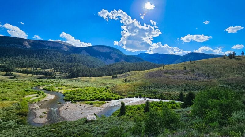
Courtesy of the very wet summer and late snowmelt, coupled with some staffing peculiarities, I hadn’t been able to really do anything. No kayaking, because during my times off it had been very cold (40s/50s with high wind and rain), and no hiking for the same reasons, combined with the late melt of the above-average snowpack. The first two weekends I would have been able to, one of my employees took vacation, so I was working overtime. The lone day off was better dedicated to celebrating the lives of my family, as this period of time snagged up my daughter’s birthday, my anniversary, and my birthday, too. When I finally did have time to hike, it was only a quick weekend. I considered Ross Lake and some of the lakes above, but the forecast was for an exceedingly hot, dry weekend, and it seemed like I’d be rather miserable given the initial climb. After some consideration and grousing to my wife, I decided that I’d do Six Lakes in the Gros Ventre. I hadn’t wanted to ever do it, but I’ve been running out of hikes that I can do in 2 days, so I decided that I’d go for it. My plan was to leave work at 1245 on Friday and hike in, then summit Black peak the next day, and leave on the last day.
⤑Day 1: Hike to Crystal Slide
Due to a personnel issue, I ended up staying a work far longer than I wanted, but given that the temperature outside was hotter than a solar flare observed at a distance of 10km, I wasn’t too disappointed. The drive from the air traffic control tower took over an hour, but the road was decent until reaching near the end, where the main road leads to the private Red Rock Ranch, and you take a left onto the trailhead road. From there I would recommend higher clearance and 4×4. It wasn’t bad, but my wife’s Juke wouldn’t have made it. Oh the Juke…
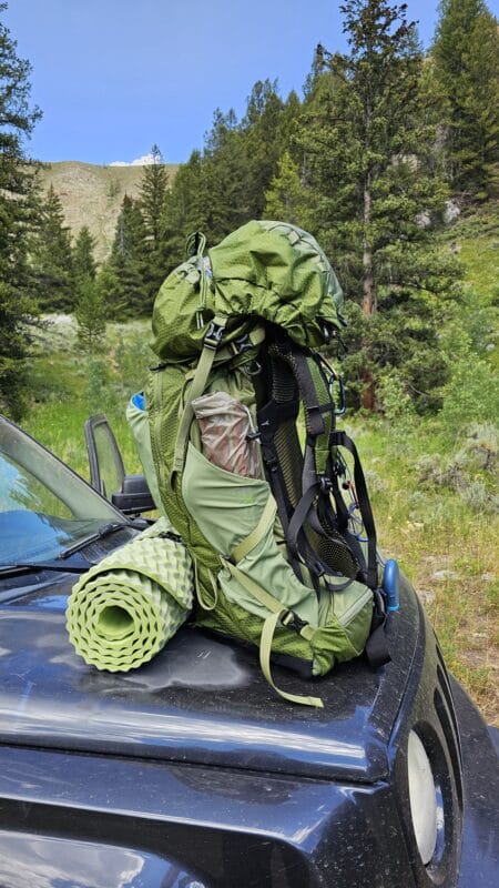
Below: My new shirt, pack, and some views on the way in. You’ll learn more about the shirt and pack soon enough!


The trailhead was pretty empty, and I continued a bit beyond as I planned to go on the use trail along the hill to the east. Under no circumstances should you take this trail. Although it was advised as not being suitable for horses online, I will advise that it is not suitable for humans and adds significant danger and time to the trip. This was also my first time hiking with the new version of the Osprey Atmos AG 65, which seemed to have a more durable bottom and a better overall design, including side zip access to the main compartment. I elected for green to help blend in, and the green is less aggressive on the eyes than the previous version, which I got in 2016. Below are pictures of the new and old pack (I am keeping the old one as a loaner), the trailhead area, and some more views of the new pack. It’s robust, and although it weighs much more than ultralight packs, I prefer the comfort. Speaking of comfort, I was wearing my new Kuhl Airspeed LS shirt for the first time ever, having recently purchased it, and boy is it leagues ahead of all of the other shirts that I’ve used. I’ve got to review it soon. Just amazing.
Quick note: I was covered in biting flies, sucking flies, and mosquitoes for pretty much the duration of this trip. I have never observed so many flies in my life. They were constantly everywhere, from horse flies to the ones with triangular wings to the ones which are likely some new species. Wretched.


I saddled up and was underway just before 4PM. I usually bring bear spray and my FNX-45 when I’m in grizzly country (bear spray for the trail, sidearm for the tent at night), but I noticed that my bear spray said that it had expired 2 years ago. Oopsie. What happens with expired bear spray? Despite Beatriz blasting it in my face and mouth, I’m not actually an expert, so I decided that it was safer just to leave it this time and get a new canister later.
The use trail was evident, so I climbed it steeply uphill, and shortly thereafter it vanished. After crashing through a spot of forest, it reasserted itself and I followed along, skirting the top of the treed area for the most part. Within minutes I broke out into the open. The hillside really wasn’t too bad…yet.
Below: On the way up, and then breaking out into the open hillside.


At this point I was foolishly happy to be at the same level as the highest point reached on the actual trail, without having to cross the river twice. That was short lived. Soon the hillside became steeper and the vegetation more sparse. The red dirt was iron hard, studded with small pebbles which served only to provide treacherous traction, keeping one’s foot from sliding only for moments before unmooring from the hard plate to which they attached. Washes intermittently cut through the trail, and eventually a large, wide wash presented itself, much steeper than the rest. There were hints of a trail through it, but after about 7 feet of travel, I realized that it was simply too dangerous. The scrub brush I could hang on to was consisted of tiny, delicately anchored grasses. If a foot gave way, I’d go careening without stopping hundreds of feet down to the river.
Below: A picture I took BEFORE it got steep, when I felt safe enough to have my phone out.

It was now well after 4 and I had to decide what to do. Far uphill the washes started, and if I could possibly ascend that far, I might be able to cross successfully. It was that or turn back. I should have turned back, but instead I made my way straight up, or as straight up as I could. I spent a lot of time going in switchback fashion searching for better traction on the hardpack. Being out of shape, this climb was not a happy one for my legs, but bigger than that was the pressure it put on my feet as they compressed askew into my Montrail shoes.
Eventually I reached the narrower section of the wash, which I thought could potentially be crossed. It was almost vertical and didn’t have much to grab onto, but a large boulder in the middle had a bush on top of it, and I was able to spring to it. From there I grabbed the bush and lowered myself onto a flat ground eddy below, then assessed how to get out of the other side. Most of the walls were vertical and over my head, so they were impossible. One side-gully had boulders hanging on in it, and they looked deeply rooted. Through some jumping and grabbing, I was able to make the small, ladder-like side wash and precariously climb up. My pack prevented me from looking straight up, but that was just as well as it would likely have made me dizzy.
Once out of the wash, I had to carefully cross straight across the hill, sometimes being forced to go higher by the lack of material to gain traction with. Numerous, smaller wash areas impeded my progress; I found it easier to scuttle like a crap sometimes, while other times it was better to face uphill so that I could grasp small plants or rocks above. One last, large wash was a challenge, and as I made my way along, I scared two big horn sheep pairs, both consisting of a mother and a baby. Eventually I was able to start going lower, though the terrain was steep, my feet ached, and the sun was cooking me alive. Across the way I saw two fishermen going along a trail (which at the time I incorrectly assumed was the trail I should have been on, but which later revealed itself to be some sort of fisherman use trail, the beginning of which I never spied) and I regretted my decision. The going had been so slow that I could have gone back, crossed the river, and been well ahead of where I was now.
Below: Sheep.


Trying to climb down just crumpled my feet into my shoes, so I finally said to myself, “Lucas, abuse thyself less, and surely you will be blessed.” Regardless, I was wearing my favorite Kuhl Transcendr pants (initial review can be found at the link), and it had been my intent to stress test them as part of my new gear review process, so a long butt-slide down the scrapy side of the escarpment fulfilled a large portion of that particular mission. Due to the rock-studded nature of the sun-hardened soil, I was certain that the pants would get some (hopefully just) minor rips in them, if not large ones. Making it down to the last, large gully to get around, I stood up and groped my own butt in the least sensual way possible…surely there would be holes (in the pants). Nope! I was flabbergasted. How could they be so tough when they feel like wearing stretchy mesh? (Actually, I’ve never done that, but I’m guessing that it feels the same.)
This revelation made me jubilant and I got some pep in my step. Crossing yet another wash, I was soon down to the wide, open field, where the river meanders through, cobbled beneath the crystal clear water with smooth river stones. My dumb path had taken me over an hour to traverse. I reached the river and watered up, plus fished a little, but the area was fished out. I soon set off with my body absolutely cooking in the sun.
Below: The first park.


The path was well worn and flat, with great views of the canyon walls. Around mile 1.5 I entered into forests, and readily accepted their cooling shade. The elevation changes were gradual and easy, and just past two miles into my journey I was briefly by the river again, though the trail soon after climbed away and I mostly lost sight of it. Three miles in I came to the split in the trail that takes one up Crystal Creek (to one’s right), or up to the Six Lakes (to one’s left). It was about another 2 miles to the Crystal Mountain Slide, which I recently found out occurred mostly in 2009, and I desired to see it in person. It was 6:45 and the shadows were growing long, so I headed off toward the little lake that was formed when the mountain collapsed and dammed the river.
Below: Scenes on the way up to the crossing.


To get to the new lake, I had to cross Crystal Creek, which is more properly a river. I grabbed two, long branches, put on my sandals, rolled up my pants, and made my way carefully across; the water reached mid-thigh and was swift. Just past midway I was too bold and hit a rock which rolled; instead of stabilizing as I normally would with a forward motion, I pivoted instead upstream on one of my magic sticks, which itself then slipped along a rock, snagged, and cracked, leading me to fall face first into the river. Through a mighty effort of my core muscles, I arrested my fall as my face grazed the river, though water ingressed through my shirt. After wrenching myself upright I assessed whether or not my SATCOM was wet. It wasn’t really. Then I opened my Kuhl shirt’s awesome check pocket, which is large enough to carry my phone, and which was carrying my phone, in fact. The phone was wet, but being an S23 Ultra, it was just fine. I put it back in and made my way out of the river, then walked about 150 feet to let my feet dry. After putting my socks and shoes back on, I continued toward my destination.
Below: I survived.


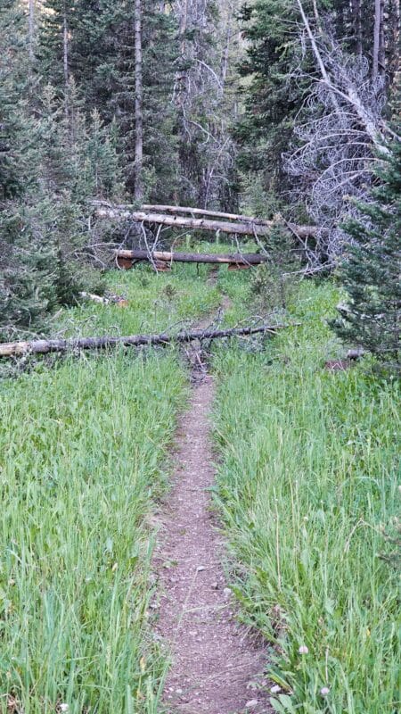
The trail was very indistinct in some areas, but after ascending 100 feet, I entered a long, narrow field where it was again well worn. This gave way to more trees, and in turn more downed trees across the path. Were they from the 2020 windstorm? From the nearby tornado the year prior? From the multitude of thunderstorms that had accosted the area all summer? I certainly didn’t know, but I was unhappy to be crawling over and slithering under the things.
The Jagg Creek Trail cutoff appeared again, a shortcut for those looking to go up to Crystal Lake from the southerly areas of Crystal Creek. The signpost was the only good indicator that the trail even existed; it seems it is not much used.

Although in my head it was a flat walk from this junction to the newish lake, reality began to sink in as I trudged uphill that it really wasn’t flat after all. As I clambered up the trail, it gained about 350 feet. There was some ducking and scrambling under downed trees, but this negative point was evened out by the plethora of wild strawberries. Although I dislike the flavor of domesticated strawberries, the wild variety is delectable. Views of the massive slide also distracted me; it’s an incredible thing to see a mountain having demolished itself. The yellow rocks were lit brightly in the evening sun. My phone didn’t do the scene justice.


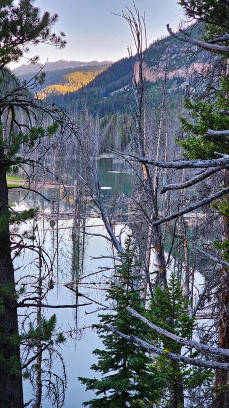
Finally I was heading back downhill toward the lake. My plan was to camp on the far, south end of the lake where it was flatter. As I headed downhill on the trail, I saw that the slide-side of the lake was effectively an open plain, mostly consisting of hardened dirt, though river grasses were present in some areas. Dead trees lined the sides of the lake, being denser to the west. The water from the outlet was milky.
After a bit of travel through the dead forest, it seemed best to turn around and find a way to cross the outlet. The lake was interesting, but a bit witchy looking. I never wish to reside in areas where Sarah Lefor might live, so perhaps the dirt plain was better. I soon found that the outlet area had a decent, shallow area to cross, and this time I didn’t try to faceplant into the river. On the far side I headed south. No great places presented themselves. Nearing the inlet I saw fish jumping like they were trying to escape sharks, and a bald eagle perched on a dead tree kept a close watch on the activity. Above the bald eagle, Hidden Basin caught some last of the sunlight being bounced off the slide; jets inbound to runway 19 in Jackson zoomed overhead. Without looking at my watch, I knew what time it was based solely off the routine flight schedule!
Below: The new lake area and a bald eagle.


The water was incredibly milky in the lake, a feature that while beautiful clogs filters. As I considered heading through the forest and to the spot I’d originally planned, I heard a woman and a man both hooting and hollering. They beat me to it! Given that it wasn’t as pretty as I’d hoped, and I wanted to get some water in me, I headed back north toward the outlet. Along the way I hopped over two little creeks that came down from the mountain; both were choked with red sediment.
Finding nowhere pleasant and not excited to be in the open view of passersby, I continued down until I reached the forest line just beyond the slide. The old trail was in there somewhere, but I couldn’t see it. I did find a nice, flat spot to put my tent; riverside grasses provided some cushion, but otherwise it was flat, smooth, hardened silt. This was the first time I’d ever used a one-person tent and I was a bit hesitant. I’d chosen the Big Agnes Copper Spur HV UL 1 with footprint. I own both the HV UL 2 and the HV UL 3, but the HV UL 1 is different in many respects, having only one door, a more unusual multi-hub assembly, etc. I’m pleased to report that not only did I not mind it being smaller, but I found myself preferring the interior layout to my HV UL 2 and HV UL 3. The design of the interior netting was far more user friendly, and I found the door very easy to use. I’ll review it in detail later.
Below: Delta and my tent.


With darkness encroaching, I used my newest water filter, a hanging bag system called the “Waterdrop Gravity” with an open top. My friend Lindsey Donohue had asked me earlier in the summer if I was still using only the Sawyer systems, and at the time I was, but then I saw a good deal on the Waterdrop, so I decided to grab it. I’ll do a full review later. Overall the bag is a breeze to grab water with, but is a bit of a pain at times to hang properly, and tends to spill out, even when wrapped down in the same manner that you might do with a dry bag. The flow rate was great, though, and it’s much easier to inspect the contents of the bag than the opaque ones from Sawyer; unlike the Sawyer bag, the pliable, rubber-style plastic doesn’t seem prone to cracking open, which is a persistent problem with Sawyer. Unlike Sawyer the ergonomic mouthpiece cannot be easily backflushed. They claim that you can flush it by blowing in it, but I prefer how I can power-flush my Sawyers with syringes. This is a major downside that could affect the lifespan of the filter. Of course I find that filters really wear down much faster than their usable lives indicate, even with routine, forceful flushing; I often just buy a new one rather than have to flush every 4 gallons.
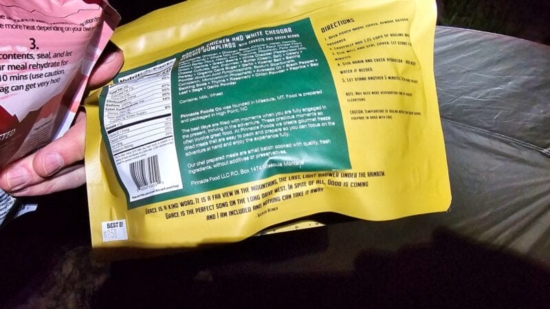
Having collected water, I started a safe fire on the barren dirt and began making dinner. I had purchased some new varieties this time, and I decided to have them both, saving my old mac-n-cheese for the next night. Tonight my dinners were Pinnacle Foods Co Roasted Chicken and White Cheddar Biscuit Dumplings and Next Mile Meals Italian Style Beef Marinara. To be blunt, the roasted chicken and white cheddar biscuit dumplings meal is my new favorite in terms of texture and flavor. After I ate it, I found out that the creator is from NC (where I grew up next door to the guy who bombed the Olympics) and also Missoula, MT, where I’m also from. It seems that he recently moved back to NC. Well I’ll tell you what, this man is onto something! The meal perfectly rehydrated and tasted in a manner that the Lord would approve of.
Below: Pinnacle’s food!


Next Mile Meals Italian Style Beef Marinara was ok. Perhaps due to its red packaging and my preconceived notions, not to mention my troglodytic palate, I was expecting red sauce. Instead I got a lot of vegetables in maybe a grey/green/brown water. I had brought Packit Gourmet’s little reheater pouch (got it for free and needed to test it at some point), an that little thing was able to hold and rehydrate both of my dinners at once. In any case, the beef marinara had a number of positives, from the veggies to actual, gooey, white cheese. The bites were a bit underwhelming and flavorless, so bring salt and pepper. Now oddly enough, when I got through the solids, I was left with the broth. I’d added too much water, making something of a soup, but the broth was really dadgum delicious. I ended up drinking it all. I’m not sure that I’d routinely pack this for myself as it had a low calorie count, but I wouldn’t turn it down if offered, and I’d again make it with more water than required.


I went to bed pretty late and watched part of Extraction II. I’d watched Extraction the previous year; while not a great show, it was fine for this sort small-screen viewing. The Hemsworth guy seems affable, too.
Sleep comfort for the night was provided by my child’s new down bag on top of the Big Agnes sugarcane roll pad, itself on top of my Sea-to-Summit Ether Lite, which had a Sea-to-Summit pillow attached using their pillow lock system. It was perfect; I’ve never slept better in the woods than that night. My kid’s Mountain Hardware Phantom Alpine 30F was much more user friendly than my REI Magma 10, though not nearly as warm. The dual zippers were so much nicer, and I loved the wider headbox, being an oval-shaped bag, rather than than oval shape with a very small head-shaped attachment that prevents you from stuffing your pillow in the bag with you, as you can see in the comparison below (note: I didn’t pay nearly that much for the bag, nor could I afford to). Since I was using the pillow-lock, this allowed me to either put my second pillow in with me, or tie it to the pack and put the sleeping bag over the pillow. I elected to do the former.


I slept better than perhaps I’ve ever slept. I didn’t wake up to pee, didn’t wake up rolling over, didn’t come off the pad, nothing. Just deep, uninterrupted sleep. If I could just figure out how to do that routinely…
Below: Awesome netting in the Big Agnes Copper Spur HV UL 1.


⤑Day 2: Crystal Slide Area to The Six Lakes
I got up at a decent time and had my morning, warmed energy drink. Refreshing! Following a bit of fishing I went back to pack my tent up and was DELIGHTED that I couldn’t find it! I always buy the most natural colors for my tents so that they won’t stick out like a sore thumb and ruin the view for others. Even 25 feet from it I didn’t see it. Having picked the spot in the gloaming, I didn’t navigate naturally back with the sun up.
Below: Inside the tent, airplanes, caterpillars, and fishing.


Thankfully I was able to orient myself with a stick and then…BAM! Tent! Had it been a grizzly I’d have been toast. I packed it up with much delight about how well it hid itself and then crashed into the forest to the north to take a look around. I had it in my mind to proceed into the area where the old USGS map said that the trail had been, but if there was too much deadfall that idea would be removed from consideration.
The forest seemed decent enough for travel, so I put my pack on and headed out. About five minutes in I came across the old trail which was in remarkably good shape. If a few downed trees were removed, it would be much more walkable than the new trail: it was wider, level, less rocky, better shaded, and had less unnecessary elevation gain and loss. I’m not sure if this trail was abandoned in 2009 or actually well before, but it was still pleasant to walk on. As I trambled (trundle+ramble) along I was entertained by the fabulous but defunct Futility Closet podcast, a wonderful look into peculiar history. It made the time pass well. Along the way I saw a North American Tree Devil!
Below: Along the old trail.


Listening to the Futility Closet Podcast, I revisited the episode about the Girl Who Fell from the Sky, an episode about an airplane which experienced a midair breakup. A lone, young girl survived and fell into the Peruvian selva (jungle).

Alone, but having been raised by ecologists in the jungle for part of her life, she made her way to safety, despite grievous injuries and being in one of the most hostile environments in the world. The episode always brings a tear almost to my eye; my wife is Peruvian and our daughter half Peruvian. How terrible it must be for a child to lose her mother in such a way. (After I returned from this trip, Yurena and I watched Werner Herzog’s Wings of Hope documentary, which can be found on Youtube for free. Herzog was supposed to get on the doomed flight but was turned back as it was overbooked.)
I lost the trail once when I deviated from it, but quickly found it again. Jagg Creek was easy to cross at this point in the year and I rehydrated myself (among plagues of flies, as usual), then set off. The trail became less distinct and I decided to head uphill toward the GaiaGPS symbology indicating the presence of the trail to Six Lakes. The going here was rather slow as there was so much deadfall, but I got through it in about 15 minutes. Afterward a use trail presented itself, and I followed it a couple hundred feet to Jagg Creek Trail! Yay! Back on track.
Below: Jagg Creek and the use trail up to Jagg Creek Trail.


Unfortunately, this section of trail had less shade and was rather steep for hiking in the heat of the day. The temperature was between 80-85 and I certainly didn’t appreciate it. A few switchbacks were present, of the longer variety; I rested on one small benchlike area before continuing on. This part of the climb is the worst of the trip and the trail then levels off, which was a delight for me to discover.


The trail then mostly became gradual uphill with the worst section being one spot of watery, muddy hell, not because of the water, but rather due to the horses beating the earth to oblivion. It was not possible to even walk where the outfitters had destroyed the trail, so I found myself climbing logs to get around it.

Around 2:30 I came to an old fence with a gate and thereafter entered the Jagg Creek Park area. An old cow camp house was across Jagg Creek, and though tempted, I decided to go visit later. I was getting a bit thirsty but didn’t care much for the water in Jagg Creek, which was tinted red with mud. Numerous trails are shown in the area of the park, but I never really saw them. I also didn’t see the trails coming from Two Echo Park. At mile 10.5 I pulled off the trail into the woods to pee, then sat down to eat some fruit snacks. As I sat there in my repose, I heard horses coming down the trail. Somehow they never reached me, though I kept waiting. The sound of some girls laughing got closer…odd. I didn’t want to burst forth from the woods and scare the horses and their riders, so I just waited quietly.
Below: Jagg Creek Park.


Then I saw them: two women rooting about on the forest floor, getting closer to me. What were they doing? I ate some more fruit snacks and waited for them to leave.
And they got closer.
Now it was awkward: if I remained, I’d seem rather creepy if they came all the way up to me. Gah! Every time they turned around, I backed up a bit and then stopped, until finally I was deeply in the trees and no longer in their view. So that I would not disturb them, I curved around in the forest and popped out well uptrail of where they had been, then left the trail again and followed the little, overlooking cliff above Jagg Park. Looking back I saw that I had been right by an outfitters camp…that explained it all!
Below: Outfitters and Jagg Creek Park, as well as a picture looking toward how I’d climb to the lake.


As I moved along, I created a quick route in GaiaGPS and tried to decide what I should do: follow the trail, or go off-trail straight toward the nearest, and largest, of the Six Lakes. Going straight would be a bit steep, and deadfall could make it a pain, but it would cut down on the miles. With that in mind, I cut down across the end of he park, hopped the creek, crossed several horse trails, and started steeply uphill. It looked best to avoid the creek drainage, so I stayed west. A few areas of bad deadfall were present, but nothing that really slowed me down. I crossed one unexpected creek, but deadfall helped me avoid getting wet.
Below: Views from the climb. Bear?


Just before 5:30 I popped out with nice views of Black Peak and the Six Lakes. A lush, green meadow led down to the largest lake and had a couple of spots that were good for camping. Interestingly, I found a lightning strike on a tree and some severe burning below it. The summer storms had been intense, and in another year this could have been devastating. I guess the likewise intense rains had limited the damage. I considered making my fire in the ashes, but the mosquitoes and flies were driving me nuts, and it seemed better to just avoid being outside as much as possible.


Tent setup was first on my mind, followed by a jaunt a couple hundred feet down to the lake. To my dismay, it was filled with amphipods of various sizes, so densely choking the water that collecting here would just clog the filter. A distance away I saw a creek, so I marched over there and started getting water from the little cascade. There was no point fishing as there were no fish to be had. Gross. I noted some fossils in the limestone that redeemed the place a bit.
Dinner consisted of Gardettos, a MoonPie, and AlpineAire Forever Young Mac & Cheese. Much like other AlpineAire meals I’ve had, the pack didn’t reheat well, even in a heaterbag inside a down sleeping bag. The meal was quit bland despite the addition of vegetables. It was more of an al dente medium for salt and pepper than anything else. Live and learn.


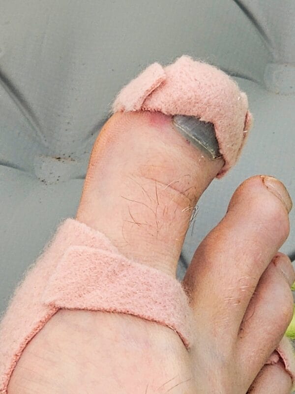
I ate dinner in my tent to avoid bugs, then put up my bear bag and watched some Extraction II. I think I’m 1/2 way through now…maybe less. I realized I’d need more water, so I rushed through the bugs to get it. Wearing sandals cost me dearly, as I banged my toe into a rock hidden in the grass. I instantly got a hematoma and a purple nail. The pain was awful! Shaking my fist at the ground I made my way back to my tent. Falling asleep was hard; I ended up sleeping perhaps two hours, as the pain kept waking me up, and naproxen did nothing to stop it. It was an awful night.
⤑Day 3: Egress
Sun and pain woke me up early, around 6, not that I’d managed much sleep, anyway. I looked at my toe and realized that the toenail would certainly be lost. Oh bother, said Pooh. I considered leaving early, but it was cloudy out and cold as well; wind gently rubbed along the grasses, but in turn would whip more fiercely.
I consumed more food and vitamin I, then taped up my feet as best I could. A SATCOM weather check said it would be cloudy and rainy. This was incorrect, as it would end up being hot and sunny. My smashed toe meant that I wouldn’t do a quick climb of any mountains. Bah.
Below: Morning views reminding me of Khul. My destroyed toe.


Sour feelings attempted to consume my soul as I packed camp. I went slowly due to my toe. Rain briefly interrupted, but then it began to clear up. I elected to head out via the official trail so that I could see all of the lakes. It was more mileage but I didn’t come all the way for nothing.
I stuck southeast along the shoreline and presently visited the next largest lake. It wasn’t a beauty. An off-trail adventure brought me to the next lakes and the trail proper…they were nothing to get excited about and something of a letdown. The trail then climbed uphill and into the forest, before popping out in a large meadow, which took me down to Jagg Creek Park.
Below: Amphipods everywhere, and pictures from the walk out by the Six Lakes.


At the end of the park I was going to cross to see the cabin, but two naked people were directly in the path, rubbing each other mysteriously in the field. How could they stand the bugs? What were they doing? I averted my gaze and continued out.
Downhill killed my toe, and on the way to Crystal Creek Trail I had to stop and make sure my nail hadn’t falled off, as it was sloshing around. The bones also hurt. My foot was swelling a bit, as well as the toe. I kept going, then took the trail I’d avoided earlier, heading out across many small creeks, some of which rehydrated me. The Futility Closet podcast helped ease the pain. I SATCOMed my sister and told her to let my wife know I might be late given my hurt foot. Maybe Somewear changed how their system worked over the winter, because only my sister could receive messages this year.
I crossed Crystal Creek rather than choose the treacherous path I’d come in on. The cold water made the pain vanish for a bit, an utter blessing. As I climbed the little hill to the north, I looked for the trail I’d seen the fishermen on. It never showed up; apparently they’re not connected. I didn’t feel in the mood to go and find it, instead deciding to look for where it connected to the main trail as I headed out.


The climb was minor but a pain. Descending was far worse; my toe striking my shoe was killer. Still, if the girl who fell from the sky could handle what she did, my worries were invisible in comparison. At the bottom of the hill I headed toward the Jeep to see if I could cross the river. While walking over, I allegedly crossed the use trails I was looking for, at least according to satellite pictures, but they were indistinct enough that I didn’t notice.
There was no way to cross the river, so I went down to the main crossing at the trailhead and did it there. It was a little sketchy even there, but again my toe felt much better. At this point there were only two women at the trailhead, doing what I couldn’t figure…they seemed interested in the dirt. I got back to my Jeep at 5:30 and headed back home. The cuticle of the nail was effectively destroyed and bulging out with blood, and the nail itself was very loose. Driving home wasn’t fun.


➤Conclusion and Rating
Due to my extreme dislike of amphipods and the relatively boring scenery, I was no fan of the Six Lakes. The massive slide was pretty cool and might make a nice day hike if you’re completely out of other options. A tour with Teton Helicopters would be pricey but likely the better way to see the area; maybe just join the horse crews who destroy the trails even. In the end, it comes down to the fact that it’s a long, hot hike with one interesting scene and one mediocre vista. I didn’t like it, wouldn’t recommend it, and won’t do it again.
A further half-star has been deducted for a reply below this review. One would naturally find such a Jacksonian denizen unpleasant to receive a comment from, much less to encounter in the wild, and apparently he may be found ferally roaming the Gros! Avoidance advised, use caution.
- My scientific rating system. An objectionable hike.
- Beauty. A middling view at one point.
- Camping spots. Unlimited.
- Crowds. Horses and naked people seem to be about it.
- Difficulty. I guess it’s technically strenuous. Mostly just hot, ennui-inducing, and interminable.
- Fishing. In the river, yes.
Do you disagree? Comment and let the world know. Or not. It’s really up to you.

2 thoughts on “Review: 25 Miles Hiking the Six Lakes in the Gros Ventre So You Don’t Have To”
The GV isn’t meant for everyone. Especially you apparently. Go hike with the crowds in the National Parks if you are so disappointed in being in true wilderness and spend as much time on writing this [profanity removed-ed] up as you do actually being in the woods.
[Editor’s note: This comment is being saved as originally written with profanity removed for an upcoming feature, “The 10 Best Hate Comments I Have Received.” God bless.
Thank you for your passion.
GB,
LHN