15 Miles: Bomber Mountain and Off-Trail Traipsing for Trout
This short hike features incredible history and excellent fishing for a rare species of trout. It’s best if you have two or more nights available.
Quick Facts and GPS
Quick info (click or tap):
—Time of Year: Sep 14-16
—Notable Features: West Tensleep Lake, Lake Helen, Lake 10,547, Gunboat Lake, Florence Lake, Bomber Mountain, Wreckage of B-17 Flying Fortress nicknamed “Scharazad,” Mistymoon Lake, Lake Marion
—Total Miles: 15.37 miles (sans all excursions; minimum distance ~14 miles)
—Elevation Gain/Loss: +/-3428 feet
—Elevation Min, Avg, Max: 9084, 10,022, 11,911
—General Route: West Tensleep Trailhead—>Tr 063—>Off-trail—>Tr 038—>Off-trail—>Tr 038—>Tr 063—>West Tensleep Trailhead—Download the GPS file with a free GaiaGPS account. I use them on my phone and in Google Earth.
Interactive map (click or tap):
Intro
I decided to visit Bomber Mountain, starting at West Tensleep trailhead. I woke up at 0400 on Friday and hit the road. My drive was long, as you can see, thought not quite as long as my previous drive to hike Middle Cloud Peak Lake, or a subsequent drive to Coffeen Park for perhaps my favorite hike ever. Welcome to living in Cheyenne…


• Day 1: Arriving Late
I arrived by 3PM and was on the trail by 3:15. The Cloud Peak Wilderness has a lot of regulations—more than the Winds—but they let you camp within 100-feet of water, which is nice. The entire trek to Bomber Mountain is very easy.
The trail starts out by West Tensleep Lake, going through boreal forests, and then goes through some grasslands. You’ll be in and out of trees, cross a stream twice, but the uphill is, at least to me, almost unnoticable. The total vertical climb for this trek was an easy 6081 feet, and the first 6 miles are incredibly gradual. Here are some common sights during the section:

- You’ll wander through grasslands often…


- As you can tell by all the investments the Forest Service has made, this is a very highly-traveled trail.
- And during the right time of year, you’ll find a ton of yummy currants.
I had decided to camp at Lake Helen as it appeared to have more trees than the other lakes, and high winds were in the forecast. I reached Lake Helen by 5:15, which is a nice, leisurely pace. It had only been 5.2 miles of hiking, so I was still fresh, but also ready for bed. On the drive up, my stomach had felt a little…off…and I’d thought about turning around. This comes into play later.

- Approaching the lake. I cut across to the right and found a place to camp. Bomber Mountain is hidden in the background.
I immediately saw a tent, which was there for the duration of my stay, but never had a resident. Later on, I would find out that a hunter had gone missing. Instead of camping by the trail, I crossed the outlet to the east and looked around. Good choice! Tons of places to camp, and all better than where everyone else camps on the other side of the lake. Plus there was no one around my edge.


- A pond on one side of my camp.
- Up goes the bear bag!
After putting up camp, I thought about dinner, but I was feeling wretched. I cleaned up a little, but the wind and cold were out in force, so I quickly retreated into my tent to read some SCPs (think free, Twilight Zone-like writings) and then watched an episode of a historical-based fiction series…The Looming Tower! It’s about 9/11, well-acted, and will make you very upset. I quickly fell asleep to elk bugling.
• Day 2: Minimal Orienteering
Waking up at 7, I ate some Further Fuel, which my stomach was mostly OK with. I had a full-day ahead of me of climbing and fishing, and at least 50% of it would be off trail, so I was on the “road” so-to-speak by 8:30. There was no wind at my camp. My toe hurt very bad, to make things worse. It appeared that I had an ingrown nail that was also getting infected.

Instead of using the trail, I had discerned that it was better to go through the trees on the east side of the lake and orienteer through a gap in the mountains, which let me see Lake 10,594, an unnamed lake. My route took me through a number of small meadows and was very easy walking. Here’s an overview of my entire route for the day, followed by some pictures as I walked along the eastern side of the lake:


- Plenty of good camping spots on this side of the lake.
- Very easy walking. You can see the gap to be shot in the middle of the frame and a couple of miles distant.
I recommend not getting too high as you approach the gap north-northeast of the lake. While it seems wise, it’ll get you in the only section of thick forest. Remain low and you’ll save yourself effort. The gap is located near an inlet by the NE end of Helen; this is less effort than going to the gap by the inlet from Lake Marion a bit further on. Smart decision.
The climb was very quick, with only a couple of boulder patches, and mostly it was just ascending grassy ramps. I was at Lake 10594 by 10:00, which included some downtime by a pleasant stream where I drank 80oz of fluid with electrolytes. That made me feel quite a bit better, though my stomach was doing very poorly.


I spent a couple of hours catching trout-after-trout at this unnamed lake, which I’m calling 10594 by the elevation I mapped it at. Most of the fish were golden trout, which are not native. Fantastic tenkara fishing. Almost too easy. I often find late August and early September to be the best times for camping, because the temperatures are better and the fishing is the best. Earlier in the season, the trout will often be too content with the excessive numbers of other bugs just pummeling the waters, but in fall they start becoming greedy and stupid.


- Sad that there are just no fish.
I listened to some podcasts on metaphysics and also some the SlashFilmCast on the Mission Impossible series as I headed out under cloudless skies. The rockfield between 10594 and Gunboat Lake is really not a bad one, and I never felt any perilous movement, which is much unlike my previous hike. I was to Gunboat Lake within 15 minutes, and Bomber Mountain came into view. I tried fishing at Gunboat for a couple of minutes with no luck. It probably has a great deal of fishing pressure. Leaving the lake, I intersected the trail up to Florence Lake.


Oddly, a tiny stream between Florence and Fortress Lakes has full-sized Brookies. Weird. I wandered around the creek and got some distance away from the very well-built trail, but returned as I exited the parks and got into the boulders. By this point, I was behind a small ridge and Bomber Mountain had disappeared from view. I was tempted to make a straight-shot through the boulders, but decided not to. The trail itself was easy and not too steep.

- Notice the brook trout in this minuscule stream.
I finally crested the little hill between me and the final lake of the ascent. While you can use either the west or east side of Florence to access Bomber Mountain, I think that the east side is easier, as there are more granite ramps to follow, rather than pure boulder fields. (Best hikes to avoid boulder fields in the Bighorns are the Powell or Middle Cloud Peak Lakes.)
On the eastern edge of the lake, past the outlet, you’ll also find a memorial to those who lost their lives in the crash. It’s on the eastern face of a rock by the trail, and often marked by a cairn, which people like Mountainpooper of instagram hate. I also climbed up the grassy ramp to the south of Florence to look down toward Soldier Park. It was pretty enough. I’ve been on those trails, too.


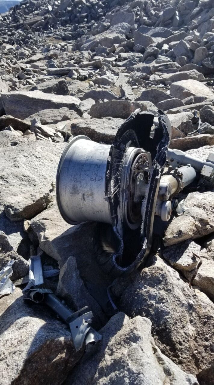
Soon enough I was climbing Bomber Mountain, and I was at the wreckage within 40 minutes, with a vertical climb from 10,875 feet to 11,946’, which puts it at a fairly low elevation and easily accessible to anyone in decent shape. Again, a leisurely pace as I just didn’t feel all that well. I felt very sad at the wreckage, and even sadder when I found a memorial to a young kid who had died. He had always wanted to hike to Bomber Mountain to see the downed aircraft, but he passed away before he could. Truly heartbreaking.


Sadly, much of the wreckage has been defaced by chuckleheads who have to put their signatures on everything. I find it highly grotesque. The rubber parts of the plane are in exceptionally good condition. There is even still oil in them.


Instead of returning the way I’d came, I decided to navigate around the “peak,” if that’s what you can call the boulder-strewn hellscape, and descend via an unnamed chute and Mistymoon Lake. A similiar approach last year had saved me 18 miles (don’t ask) coming off of Goat Flat outside of Dubois, WY, which, by the way, is a similar alien hellscape. The contour lines for my planned route were just on the verge of being unsuitable, but I figured that I’d give it a shot.
As I made my way up and around, the drainage to Lake Solitude came back into view. To my right was…more wreckage! How??? Did the Army blow it up after they found it? I know that such used to be a common practice, but I can’t figure out how the pieces came to be so widely scattered. I inspected the bits that I found while listening to the Flop House’s Godzilla review, then aimed down along the path of least boulders. Cell service here was excellent and I messaged my girlfriend that I was safe.


- Cresting the boulder-strewn hellscape instead of going back the way I came.
- Lake Solitude comes into view. Spectacular!

- A vast land. Use the grassy ramps to the left of frame for an easier hike down.


- Rock formations going down.
- Looking back up. Don’t roll your ankle.
Eventually I was getting near a pseudo-precipice, and my inclination was to follow some grassy ramps off to the left, instead of taking the chute down. I had a hunch that I could perhaps even find a straight shot down with grass if I went beyond the view-horizon. Despite this hunch—which I would later find to be absolutely correct—I decided to navigate to the right of the main chute, which had some grass, but was still mostly scree, talus, and shifty boulders on an incredible angle. I mostly did this because I thought that the view was worth the extra time spent picking my way down (I’m a rock nerd), and it was.
Soon enough I was at a creek where I drank three, 32-oz servings of water and electrolytes. I then walked on down the draw, keeping to the right, and crossed the creek closer to the bottom. I saw a small game trail through the rocks that simply started and ended in nothing, along with a panoply of pikas. While I expected that I might have a lot of uphill as I angled over to the left, such was not the case, and the walking, other than a couple of spring-fed marshes, was easy. I observed that my hunch about the grassy-descent on the far side of the mountain was spot on as I rounded the hillside. Regardless, I was finally off Bomber Mountain!
I had picked up an old trail, and I honestly don’t know what it had been used for. It was mostly grown over, but still deeply rutted. Never seen the likes of that before. I shot past a couple of meltponds and through a gap to find myself overlooking Mistymoon, Marion, and Helen Lakes. It looked like a short jaunt, but I knew that I still had 4 or so miles to go, and it was getting dark, with the sun below the mountains. Unfortunately, getting this view meant that I was away from the trails, so I had to cross more boulder fields to find the trail back.
This same trail goes down to Lake Solitude, and a branch goes over by Lily Lake and to Battlecreek trailhead, which I used earlier this summer to access the Middle Cloud Peak drainage. Oddly, while the trail shows up on the map, and I could see it faintly from high up, I was never able to locate it when I was on the Solitude/Grace Lake trail. My suspicion, based on some discrepancies that I noticed back on my birthday, is that it was “moved” approximately 1-1.5 miles from its original intersection. I might check that out one day.


- A little pond at the bottom. I ended up in some marshes from springs which feed this pond.
- Somewhere there’s a trail which goes to Solitude.
- The old trail…to where? Well Mistymoon. Not sure where exactly it was made to go to the other direction.


- Lake Helen a few miles distant in the back. I could tell that I’d be getting in after sunset.
- Looking back at the gap I shot to Mistymoon. Do not take that gap. It’ll slow you way down.
The trail back to camp featured some undulation, which I hate, and moose, which I despise. I also saw about 6 tents, so obviously a lot more people had arrived. This time I went to the west of the Helen because a.) I didn’t want to encounter a moose in the increasing gloaming, and b.) I wanted to see how great the trail was. Suffice it to say that it is much easier to travel off-trail on the east side of the lake.
Three moose which I skirted around at a distance. I’ve been chased by them before.


- The trail back. Saw a bunch of elk.
I arrived and grabbed a chilled Coke which I had brought along. A first for me! It was very cool from being in the lake. My tummy still hurt, but I tried two bites of food…couldn’t do more. Drank a bunch more fluid, too. It was very warm and still, being perhaps even in the 60s, so I stripped down and bathed myself. Felt so good. Thoroughly washed my hair, too. My toe was in bad shape by this point, but I didn’t care. Weather like this so late in the season would make a leper happy.
Gross Picture

• Day 3: Exodus and Home
By this time, it was quite dark out, so I watched TLT and read some SCPs, then fell asleep. I woke the next morning to a crisp air at 6, and didn’t really feel like being invigorated that early in the morning, so I fell asleep again until 7:30. I was on the trail out by 9:08. With stops (people coming in wanting to chat, as well as some fishing), I was back at my Jeep by 11:12.

- See ya later, CPW!
The following week I met up with my mother to hike to Frozen Lakes and Lake Angeline. It was below freezing and very windy, but a very interesting hike meteorologically and had some great fishing. Strangely, that short hike also had far more elevation gain! More on that some other time.
Conclusion and Rating
This is a very good, fun, historical, and easy hike!
⭐⭐⭐⭐ ☆ (4 stars)
Detailed explanation:
- I truly enjoyed this hike.
- The history was awesome.
- The fishing was fun.
- The camping spots were plentiful.
- The wildlife was present.
- But so were the people.
- And it wasn’t all that strenuous for what I got!

6 thoughts on “15 Miles: Bomber Mountain and Off-Trail Traipsing for Trout”
Thank you for including my Brother David in this article. He passed away from Suicide in 2014. And he always wanted to hike Bomber Mountain. He was the best. My Step Dad and Grandpa and Cousin hiked Bomber Mountain after his passing and put his picture. Truly appreciate it.
Tia, that is heart wrenching sad to learn, but I am glad to finally know about the story behind the memorial. I can’t imagine hiking up there to make it, but it is what I would have done as well. You have my eternal sympathy. <3
Again, my name is Lame. And you and others who visit these places, or use this website, sicken me. While we’re at it, may Satan smite any forest service employees who dare mention these areas.
I hope you rot.
Cheers,
Lane
PS-Had my small child help me with spelling, it is not my fortay. She started literally crying realizing you are despoiling these areas.
Hi again, Lane. I hope that Laramie is treating you well.
Have a wonderful life.
-Lucas
I’ve been to CPW many times hiking. But never knew which lakes had golden. It would be nice to catch one some day. I’m now 66 and won’t be backpacking anymore 🙁 Any easy hikes to a lake with golden trout ? Thanks.
Hi Steven,
For some reason your comment got ganked by my spam filter. Many of the places that have golden are stocked semi-routinely, but they’re also often pretty far from the beaten path. If you have access or can afford to rent llamas ($$) or be taken in on horseback ($$$$), that makes things easier. Still, Upper Sweeney Lake out of Pinedale is stocked with golden trout, and it’s something of a neature walk in if you’re able to do it. Other lakes that are somewhat close to a road are Lower Jade Lake (https://goo.gl/maps/FspUeaappMDE4tmG7) and Daphnia Lake, which is closer to the CPW. (https://goo.gl/maps/sArnDWKkFTiQY1fK6)
The remote lakes experience the least fishing pressure, so generally they’re better to fish, of course. If you’re interested in a recent stocking report (ctrl+F for golden), you can view one here: https://wgfd.wyo.gov/WGFD/media/content/PDF/Fishing/Stocking%20Reports/WGFD_FishStocking_Report_2019.pdf