Review: 19 Miles Hiking Simpson Lake, Plus Dead Horse, Long, and Union
➤Quick Facts
Information at a Glance
- Time of Year: Early September
- Notable Features: Union Peak, Three Waters Mountain, Union Lake, Moon Lake, Blanket Lakes, Simpson Lake, Simpson Lake Cabins, Long Lake, Dead Horse Lake, Dyke Creek
- Total Miles: ~18.2 miles
- Elevation Gain/Loss: +/-3068
- Elevation Min, Avg, Max: 9667, 9855, 10151
- General Route: Moon Lake “Road” ►Simpson Lake Trail ► Off-trail to other lakes ► Return via reverse route.
- GPS Track Download Download with a free Gaia account by clicking on the “data” section. I think you have to be logged in. Works on GPS programs/Google Earth.
- Housekeeping: Feel free to contact me if you’d like full-rez/high-quality images or more information about anything. I host the images on my site with compression and display them to you via CDN so that they’re fast.
Interactive Map (Click to Show)
⤷Introduction: Deliberation and the Hell of Moon Lake Road
My boss was on vacation, so I was once again going to have very little in the way of free time. My wife was fine with me going out into the woods again, but it would have to be somewhere close to my job. I’d be getting off at 5PM, and with darkness around 8PM, that would leave very little time to hike the first day. Effectively, I’d have Monday to hike in and Tuesday to hike out, and work on Wednesday at 1PM.
While at work Saturday, I was doing some thinking about my plan to go to Granite Lake. It was quite an off-trail hike in, and I wasn’t sure how far my Jeep would make it. I decided that I might go to Simpson and Dead Horse Lakes, as they were just on the other side of Union Peak, and Simpson Lake features some historic buildings, originally built in 1926, and used as dude rancher lodging until the mid 90s or so. They are now lightly maintained by some volunteers, but being in the middle of the Wind River Range and in one of the least-trafficked areas, they don’t see many visitors. Still, I love historic places, and these are on the register for historic places with something of a history, so it would be hard to say no to the opportunity. In my mind, I decided to check out both Moon Lake Road, which leads toward Simpson Lake, and the Union Peak Road, and then decide from there which I’d visit.
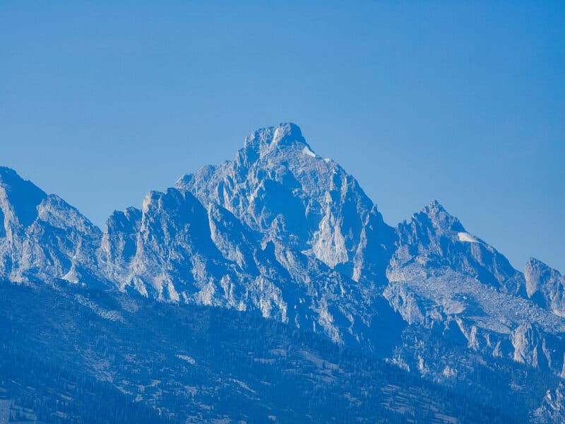
I left work around 5 and realized that I wouldn’t make it anywhere productive for hiking, so I stopped by the Fireside Resort to pick up some food and drinks, as I didn’t really feel like making a re-hydratable meal and filtering water in the dark, and of course trying to find a creek. I grabbed a cheese and meat tray, some gummy worms, a couple of Powerades, a soda, and a few other items, then got a tiny bit of gas and zipped on up toward Togwotee Pass. The view of the Tetons wasn’t too smoky, and I hoped that it would be good weather for my trip. NOAA had warned that it would be rather too hot for my liking, but what’s a guy to do?


The trip up and over Togwotee Pass was uneventful. I’d preloaded my GPS maps and also Google driving instructions, so I was soon driving off the main highway and up to Dunoir, which happens to share a name with DNW, a VOR that I use for aviation every day. Along the way I stopped to use a well-maintained restroom, and noted the absolute plethora of ATVs. They were everywhere.


I passed Moon Lake Road and went toward the ingress point o Granite Creek, where I was immediately met by a nasty little crossing. I decided to turn around and head toward Moon Lake, as it was getting dark. Moon Lake road itself wasn’t bad…at first. There were people boondocking about, but not too many of them. As the road started to get rougher, I passed a couple of FWP vehicles with horse trailers (I never ended up seeing the pinecone police, though)…and then the going got really tough.


The first sign that this road wasn’t friendly toward vehicles came at the first real “downhill” segment. I basically had to get my wheels going over the boulders, boulder to boulder, sometimes with only 3 points of contact, though always in 4-wheel drive. Sometimes I simply slid down the hill, and other times I had to put it in low gear and creep along. The boulders were large, and some were sharp. I was worried for my oilpan and tires.
At the bottom of the first hill, I then had to drive over a mostly-dry creek area. Here the rocks were all shaped like vicious pyramids, looking to puncture my tires. I hoped that there were enough that no one would puncture into my new tires. Following another area like that, I decided to call it quits, because looking ahead was another creekbed, and then a steep hillside with large boulders that I wasn’t convinced my little Cheap Patriot could make it up.
I unpacked my stuff and got my Jeep bedding (different from my backpacking bedding) set up. I wondered if any of the pinecone police would complain about my parking on the grass. I try to stick to roads and trails, but there wasn’t anywhere to really park along the road.

I read and watched some shows, and the night didn’t get very cold. As I was reading, I suddenly woke up at 1:38AM. How nice! I’d just drifted right off, which I can never do at my own home. The wind was rattling my Jeep something awful, which was why I’d woken up. Gah! I hoped that wouldn’t stick around for long. I drifted back off as my Jeep swayed side to side.
⤑Day 1: Hiking to Union Lake, Moon Lake, Blanket Lakes, and Simpson Lake
Around 0830, I woke back up to cows looking at me. Moooo! It was chilly at this point, and the hike to Simpson Lake wouldn’t be long, but I decided to read some more before packing up for the day, especially given that it was still as windy as all get out. I also made myself some breakfast and loaded up on fluids. As it would later turn out, my continued illness was walking pneumonia. Good stuff!

I eventually got everything packed up and started moving, but I felt exhausted. I had a little anxiety over the rest of the drive, too, and hoped that I wouldn’t destroy my Jeep, but I didn’t want all the extra mileage for hiking. Leaving my little parking area, I headed down and crossed another creek. The rocks were atrocious, but I made it, and then had to place the wheels along a bank and in the center of the road so that I wouldn’t bottom out. Making it to the base of a hill, I scrabbled up in 4 wheel drive; once I got a bit stuck, but managed to get out and keep traveling. The road was not better from there. In fact, after getting to a fork in the road and going right, the hillside I had to climb gave me significant trouble. I realized that, coming back, I’d probably have to go across the grass to prevent terrible damage to my little Cheep.
The area of woods after the fork featured tight spaces and big boulders, which I thankfully made it through, bringing me down to yet another creek. Not being able to see what was under the water was a bit anxiety-inducing, but I crossed and drove a while more. Approaching a hill about 5 minutes later on, I decided to park and call it quits. The rocks didn’t look like my Jeep could survive them, and I’d pushed my luck enough. I got out and checked my vehicle…there was miraculously no damage! My tires showed a lot of sidewall rubbing from some of the boulders, and especially the one hill that had given me the most trouble, back just across the creek. Going down it would probably do terrible things to my vehicle.

As much as I wanted to hike, my illness was taking a toll, so I turned around and headed back to Jackson. Just kidding. But I did take a little rest in my Jeep, then ate some lunch. I deliberated which food to bring: my Peak Refuel chili mac, or my Mountain House chicken n’ dumplings. Peak Refuel had been treating me well the whole summer, but I’m not a huge fan of chili mac. On the other hand, while chicken and dumplings are my favorite mountain house meal, I wanted something with a tangier flavor. The only solution was to take them both! This was fine weight-wise, since I’d forgotten to bring my camera’s memory card, and wouldn’t be needing it. Why not get fat on the trail? Finally heading out around 1:20PM, I walked for 15 minutes, and then realized that I had a spare memory card. Oh well, I wasn’t going back. I decided to cut down the miles and avoid the hill by bushwhacking through the forest. It wasn’t a bad walk, and I came back to the road naturally given the terrain. Someone had eaten a watermelon. The road was spectacularly bad, so I was glad that I’d decided to stop when I did. No one would want any part of that. It’s certainly made more for ATVs than vehicles.


Looking at my maps on Gaia GPS, I realized that I could visit Union Lake and some ponds without too much effort, so I broke to the west from the road and started back toward the woods. Let me just say that the bushes along all of the creeks in this area are dense enough to crush one’s soul, so it’s worth avoiding them. I should also note that this added distance, rather than subtracting it. As I pressed onward, the wind would occasionally abate, though it made things worse, as the sun air was surprisingly hot. The smoke didn’t make things better.


I entered into the forest which had almost no understory. The hiking in this area was probably the easiest of the whole trip. After passing a small pond, I started descending the 300 feet toward the lake.
About 1000 feet from Union Lake, I came upon an unoccupied outfitter camp. It even had a couple of bear boxes and was right by a creek! I stopped and got some water, ate a few chips, then continued on, finding a small path that didn’t seem to head toward the lake. Strange! I decided to make my own way down to Union. It was somewhat underwhelming, not having anything truly scenic to recommend it, and also lacking little lawns at which to camp. Near the outlet I saw some brook trout and wished that I’d brought my fly rod. On the plus side, it was still windy most of the time.


The creek between Union Lake and its ponds also leads to Moon Lake, so I followed it out. Some fish jumped at various spots, but they seemed somewhat small and not worth the effort, if I’d even had my pole. The walk between ponds and down to Moon Lake was pretty tame, but it still took longer than I liked. I grabbed a few huckleberries on the way, and was sad that they didn’t have nearly as much flavor as the ones I’d always eaten in Montana.


3.5 miles into my journey, I came to the banks of Moon Lake. It was being pummeled by wind, but again, given the heat I was fine with it. Moon Lake sits around 9700 feet and has an “L” shape. It’s surrounded by forests, but they’re not too attractive, and the nearby mountains are slumpy looking. As I passed by the road, I was sure glad that I’d left my Jeep behind.
The banks of Moon Lake, at least in this area, were covered with brush, and led steeply down to boggy areas which I had to traverse. I managed to avoid getting my feet wet as I stumbled through the bushes, and soon came to another road. Well, ATV track, really. Here I erred: I chose to go along the edge of the lake, rather than following the road, which led downhill. To my credit, the lakeside had spots worth camping at, so I was transfixed by them. Some extra stupid part of my brain considered setting up camp here and day-hiking to Simpson Lake, given my terrible cough, but it was early and hot, so I pressed on. As I mentioned, it was stupid, because I then had to navigate the outlet, completely oblivious that there was a great bridge just 200 feet away. After almost killing myself, I was on the southern side of the creek and back on the trail.


The trail in this area is well-worn and often used by horses, but it’s not beat to heck too much. There are really no places to camp, as once again the banks are steep, and not even halfway along the length of the lake, the path heads uphill and away from the water, to which it does not return. The uphill is pretty gradual, and despite my rattling cough, which I was afraid might attract mountain cougars, I found it not all that bad.


Around 4.7 miles into the hike, I came across a little meadow with a nice creek and easy access, so I stopped and ate some more food, got water, coughed a ton, and watched a short TV show. Yes, I felt awful. Then it was back to the trail and back uphill, crossing a few wet spots before finally arriving at a little pond around 9999 feet. The elevation made me happy!


Having snapped a few pictures on my phone, I trundled down the hill toward Blanket Lakes. It’s about 400 feet down to them, but a benign walk, without slippery gravels or bogs. There wasn’t much to see given the trees, and before I knew it I was popping out at one of the Blanket Lakes, instantly observing that I wouldn’t be bothering with seeing the other one. They’re not attractive lakes at all. Seriously not pretty to look at. Don’t bother with them. You can do better. You deserve more.


It’s only 3/4 of a mile between Blanket Lakes and Simpson Lake, and pretty flat. Right after leaving Blanket Lakes, I had to cross what I believe is called Dyke Creek. It had plenty of brook trout in it. Somehow I missed the fact that there were plenty of rocks with which to cross literally just 3 feet downstream. I ended up crossing on a log about 75 feet upstream, instead. I zoned out a bit during the walk through the forest toward Simpson Lake, but I recall passing a small pond just before Simpson. I also longed for my wife and child to be with me. I hate making so many great experiences that I’m only able to share online. (Granted, though very few people read these or visit my little scrapbook, my friends and family do…and then do the opposite of what I advise! HANK! PEGGY! MOM!)
I cruised into view of Simpson Lake at 5:39, just 4 hours after leaving my Jeep. Given all of the resting I’d done (well over an hour), it wasn’t the worst time, but also certainly not my speediest trek ever. Whatever! I had pneumonia. Not too bad for a man who sounds so lousy that he attracts mountain cougars!


Simpson’s trailhead-side featured much open space and plenty of places to put up a tent. They were all quite nice and tempting, nestled beneath trees which had high branches, and most had fantastic views of the Wind River Range across the waters. Having a view of mountains across a lake is always most tempting to me, but I had my heart pretty set on the historic cabins, so I elected to press on. I sure hoped that I wouldn’t find anyone there, but I hadn’t seen any fresh horse poop, and the tracks all looked old. In fact, I’d seen no human footprints at all.
Simpson Lake has a small lake just downstream of it, so I had to cross the river between them. I wasn’t eager to take off my shoes, but it was requisite. The best place to cross is right at the trail, because it’s the shallowest, and there are no places where you can hop rock-to-rock. Thankfully, someone or someones had crossed at some point and left magic sticks. I was delighted to find them, just as I was delighted that I’d brought along my sandals, which I’d highly considered leaving behind. The rocks would not have been fun on my feet!


Crossing was a frigidly refreshing experience. On the other side, I kept my sandals on to allow my feet to dry and kept walking. I soon came across a pleasant, treeless area, but once again decided to push forward in search of the cabins. Coming across a little beach, I sat down and put on my shoes. The beach was more obliterated granite than sand, but still nice. I listened to the Reason podcast goons babble on out of both sides of their mouths. Such beltway people.


Just under 1/2 a mile past the crescent beach, I broke out with views of the cabins! There was an old fence along the property, which featured natural grass laws and some bushes in various places. The cabins sit in an opening with trees which mostly block views oh the lake, though the north side has bushes rather than spruces and pines. I crossed a pretty creek and went through the old gates, perhaps a bit quietly so as not to disturb anyone who might be present. God blessed me, though, as I was the only one there!


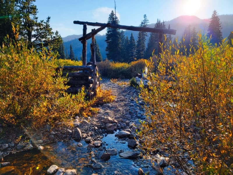
I kept my pack on as I moved through the dead-silent old ranch area, then dumped it as I searched for places to camp. I prefer to camp among the trees to avoid notice, but that seemed impossible. The south side of the lake was too cramped with trees to camp near the water, so it became quickly clear that I wouldn’t have a view from my tent of the actual lake.
I decided to camp in a small lawn encircled by bushes just south of the main cabin. My tent is huge, but it still wasn’t super noticeable. After setting it up, I checked out the cookhouse, which was open. It was pretty awesome. I noticed some socks hanged up to dry inside. Would someone return for them? (Hint: no.) Outside the cabin, hidden under some wood, I found another pair of socks. These were clean and almost fresh. Weird. Since they were still bundled up, I decided to pack them out if no one showed up for them. In the meantime, I took a few pictures of the area.


It was then time to collect water. I went back to the stream and followed a path up a ways to a small waterfall, here I collected 3 bottles, a kettle, and a Sawyer pouch worth, then went back and started my Jetboil. I put the boiled water in the chili mac first. I wasn’t too hungry, so I didn’t know if I’d eat my chicken and dumplings right after the chili mac, or if I’d save it for the morning. Regardless, while the pouch was rehydrating, I collected wood and dead bark (quite a hike to carry it back, as I didn’t want to mess with the trees nearby) and made a small fire. While I could have eaten in the house, I didn’t want to leave food smell in there and encourage bears to break in, as I’ve had happen before.


Finally I sat down by the fire and ate my chili mac. Parts of it were a little al dente, and while it was good for chili mac, it wasn’t worth the extra money compared to other chili macs. (The other Peak Refuel meals have all been well worth the cost!) I managed to finish it off, an by golly I was still hungry, so I made the C&D, too. THEY WERE SPECTACULAR! Yum, yum, yum. In fact, the amount of food I ate that night was the most I’d ever eaten. Incredible.


Then it was time to clean up, so I got my little Rainleaf towel and did just that, brushed my teeth, then got in my tent and decided to watch some shows. I had used Amazon Prime to download a few movies, but for some reason they wouldn’t play. Oh well! I was left with some cartoons and reading, instead. I strapped my 45 to my wrist as I watched, and found myself once again waking up in the middle of the night, having fallen asleep without expecting to. That’s pneumonia for you, I guess. The night was warm and still, and as silent as the grave, and my pad was a bit deflated. As it turns out, it wasn’t a hole. Rather, I’d somehow opened up the fill valve. I puffed a couple of times until my pad was more pleasant, then fell right back asleep.

⤑Day 2: Hiking to Dead Horse Lake, Long Lake, and Back Out
I woke up around 8. It was chilly, so I read and grabbed some food, which I ate in my tent. At 9, I got up and started tearing down my tent and packing up. My plan was to hike up to at least Dead Horse and Long Lakes. I was still coughing like a man who coughs a lot, so I doubted that I’d have time to really get up to Lost Lake, factoring in rest breaks. I also took some more pictures of the surrounding area and went a long way into the forest to have my morning constitutional. The ground was very granitic and digging a suitable cathole took over 10 minutes. Note: I can’t STAND when people don’t dig a good cathole and just leave their TP out. Have some respect! Oh, and I also hacked up something bloody. All told, a great morning.


Oh, and I took another rest, as I was sick. It was a pleasant day to lay down with my head on my blanket bindle and make some progress on a book. At noon I moseyed on out toward Dead Horse Lake. While there is a trail that goes to Whiskey Mountain, I wasn’t on it, or at least I don’t think so. I believe—and this is not a religious statement—that Whiskey Mountain trail cuts back east and goes around Shale Mountain down to the Ross Lake area. I believe this mostly because that’s where Whiskey Mountain is. The trail I was following seems to go up to the pass east of Three Waters Mountain (where, by the way, water will split and go to three different oceans), and from there is no longer listed. I suspect it would be a part of the Wind River High Route. Having hiked a part of that up to Clear Lake from Green River Lakes, this way would be far better, and I’ll probably use it in the future.
The trail followed the sides of the lake, but back a bit in the woods, so I didn’t have to worry about sunburn at all. In fact, I’d not brought any sunblock or bug repellent, given the late season. It was much easier to just wear my hat, and I am otherwise always fully covered outside of my hands. I soon came out of the woods and upon a beautiful little lawn that had plenty of space to camp. Beside the meadow was a large bunch of bushes that extended from the lake and up toward the mountains…a creek must be there! Sure enough, I crossed the creek, which was just gorgeous. Lots of trout in the area.


After crossing, I considered following the unwooded area up to Long Lake, but then decided that it was better to go on the trail an make the cut-across to Dead Horse instead, as then I’d have less time lost if it turned out that it was a poor decision. Along the way I saw exactly no one. The trail sticks to a little tongue of elevated land that separates Long Lake from Simpson Lake, and somewhat strangely doesn’t get all that close to Simpson.
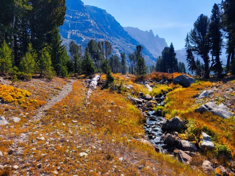
At 1224, I came across a creek that descends from Dead Horse Lake, which somewhat surprised me. Dead Horse is up higher than Simpson, and just a little higher than Long Lake, so I’d assumed that it would have a creek down to Long. I was wrong! In any case, I made my way down to the small river that flows into Simpson. I didn’t see any fish, but it sure was picturesque. My heart ached a bit that I’d had so little time to explore the wild backcountry this summer.


I turned and started hiking uphill toward Dead Horse Lake. There was something of a trail, but it appeared to be from animals rather than humans. Dead Horse is worth the little excursion, and can be reached in five minutes or less. It didn’t seem to have fish, but the view of the mountains made me want to camp there, anyway.


As I stood on the banks, I considered hiking to Lost Lake, which is up in the hanging valley beyond. It would be boulder-hell to get there, and I was still coughing and in rough shape, plus I had work the next day…I elected not to go. Again my heart was sad, but perhaps I’d get another chance before my spirit departed my body. So far I haven’t, but hey, it’s only been about a week as I’m typing this!


With Lost Lake out of the question, I made my way toward Long Lake to the east. There is a little spine of terrain, probably 30 feet high, that heads east and is covered with trees, gradually becoming flat. Between that spine and the mountains to the south, the ground is mossy and marshy in spots, but it rises ever so slightly between the lakes that there is no creek. The water most flow mostly from underground exfiltration, if it flows much at all.


I made my way down from the spine to the marshy ground to get some pictures, but then returned back to the high ground as I made my way close to Long Lake. The banks of the lake are very steep with no places to camp, as it sits in what is effectively a large ditch. Up on top, the area was flat and grassless, filled with pines, and strangely a well-worn trail, which I followed. At some point I stopped and ate some food, including whortleberries that were all around. Yummy!


Around 1PM, I climbed down to the eastern edge of Long Lake and walked along the grassy area that leads down toward Simpson lake. I came across an exceptionally clear creek that fell in large cascades straight from the cliffs above, and there I got a bunch more water, which I paired with some berry Propel packets. It was incredibly refreshing!
Listening to Dr. Bruce Geryk talk about tabletop games, I crossed the creek, then crossed it again to the north, making my way back into the forest to avoid he panoply of bushes in the riparian zones. In the middle of the forest, along the side of a small hill, I found some barb wire. Why was it there? Why was it roped around trees? Does anyone know? Shortly after, I came across a bull elk, who I spotted just before he spotted me. I didn’t manage to get pictures without alerting him. We went our separate ways, with me noting that I now knew which animals were probably making the nice trail just a ways back.


Soon I was back at the creek crossing by Simpson Lake, and from there I returned to my camp. I ate the rest of my food, finding it better to carry it in my belly than on my back, drank as much water as I could stand, an headed out at 2:30. I was hoping that the water would help me cough up whatever was in my right lung, but instead it just made me feel like I was drowning. Yay! Aquaman!
The weather was getting less smoky, and I contemplated camping again somewhere, yet I had nagging worries about my Jeep and the road, so I decided to forge ahead. After crossing the Simpson Lake outlet (where I left a magic stick for the next traveler), I ate a ton of huckleberries, and from there passed on by Blanket Lakes, making the climb to the ridge between them and Moon Lake. It didn’t even feel like that much of a climb!


Coming across the meadow above Moon, I stopped again for water and to rest. I probably rested for too long, because I didn’t reach Moon Lake until 4:53. It was worth it, though, because I felt fresh, coughy, and ready to tackle the road back to my Jeep. Instead of trying the precarious crossing of the Moon Lake outlet, I followed the trail a couple of hundred feet and came to a perfect bridge. Go figure!


My maps showed various “roads” leading back to my Jeep, and I elected to follow the first one I found. At a grassy overlook of Moon, it branched left to an old trail that was blocked by trees that had been purposefully left there. Should I follow it? The way I was going wasn’t on my map, and just went uphill into some trees. Ah, what the heck, toward the trees I went, and listening to Futility Closet as I did. (A gruesome tale of two sisters who suffered under a vile doctor.) Speaking of which, my nipples were chafing badly, so I taped them.
The road was unspeakably bad, even for ATVs, but it was fine for me. After a while it joined another road, which I took to be Moon Lake road. I suspect that the blocked path was an old ATV trail that led more directly to the road. In any case, the road itself remained terrible. While I’d heard that it was a steep climb, I didn’t find it too bad. Approaching the high point of the journey, I came across some people sitting by the road with a lot of what I’ll call outdoor luggage. They didn’t seem to notice me, though, and I continued past silently.


Eventually I came across a well-worn path that went up a hillside away from the road. It was littered with horse tracks, which I took as a sign that I should follow it. Boy was I right! It climbed the hill a ways, but then cut very directly toward my Jeep, and saved me a bit of hoofin’ it.
I got back to my Jeep at 6:31, with the shadows very long. The Jeep was in perfect, working order, which was a blessing, so I drove back in such a manner as to keep it that way. At the point where I about destroyed it the first time (such that it turned on my emergency recorder), I went a bit into the grass to avoid a worse fate—the engine was smelling funny and I didn’t want to risk it getting stuck out there. Luckily there was apparently an old section of road there, so it seemed that people probably come and go based on how acceptable either track is. Going downhill, I don’t think that I could have crept in such a way that I didn’t leave the vehicle destroyed and blocking the road. Anyway, here’s a video in and out, and some pictures:


I arrived back at the main road around 7:20. I wanted to be with my family, but it was also late and I was tired. I probably wouldn’t make it home until 10:30, meaning that I’d be in bed by 11, so going home would just wake up my wife. Blah! I got on my satcom and told her that I was going to stop at Lake of the Woods for the night. She told me to be safe and that she loved me!
On the way toward Lake of the Woods, I stopped by the Union Pass historic site. After some pictures, I took an unnamed road to Lake of the Woods. It was pretty dang terrible in spots, but better than Moon Lake.
Lake of the Woods appeared at 7:40, under a gorgeous sunset. I was the only one around, so after checking out a number of boondocking sites and fishing for a bit, I went down to the flattest, best one right by the lake. It didn’t have trees for concealment, but since I was the only human, that didn’t matter.


Bed preparation didn’t take too long, and I once again found myself falling asleep without effort. During the night, I woke up to it being far colder than the previous nights, with frost over everything, but I otherwise slept soundly. Perhaps too soundly, as I woke up with a tweaked neck! Bah!


➤Conclusion and Rating
Moon Lake isn’t worth a hoot, but Simpson is truly a blast to see, just for the history alone. It doesn’t have soaring peaks, but it still gives a unique impression: people who were tough, surviving in the middle of nowhere for enjoyment. There were a ton of fish, though I didn’t get to fish for them. Overall, I’m super happy with the hike. The only downside is the road in. It is probably best to rent an ATV for that portion, or you run a huge risk.
- My scientific rating system. I truly enjoyed this hike, and wished that I’d had more time to spend on it.
- Beauty. Not rugged like Middle Fork, but still with a unique and serene beauty.
- Camping spots. A plethora.
- Crowds. This isn’t that popular. I saw no one else on the trail, and only two people on the road.
- Difficulty. This hike is fairly easy for anyone who’s used to hiking at higher elevations. The main difficulty is the road, which could really leave you stranded.
- Fishing. Lots!
- History. The cabins were amazing. Highly recommended.
If you have any questions, comments, or anything else, feel free to post below. I’m here to serve you, so let me know if this wasn’t helpful, or if there’s anything I can do to make this better.

2 thoughts on “Review: 19 Miles Hiking Simpson Lake, Plus Dead Horse, Long, and Union”
Thanks for the write-up. Gives me another place to put on my list and hopefully get to it someday.
Hi Cory,
After I wrote this, my wife and kid rented an OHV and drove to close to Moon Lake over Labor Day weekend. We expected the area to be packed, but we ended up only seeing an old couple (just on Moon Lake Road) ripping around on a little Yamaha. Seems that this area stays pretty quiet compared to much of the Winds. Hope you get up there! I ended up hiking the pass out of the Simpson Lake area and that was also a beaut!