Review: 29 Miles to Twin Lakes, Pyramid Lake, and Mount Hooker
Pyramid Lake was rumored to have golden trout, so we decided to tackle it and look at the Hooker, too.
➤Quick Facts
Information at a Glance
- Date of Visit: 22-24 September
- Notable Features: Meeks Lake, Fish Creek Park, Mirror Lake, Dads Lake, Marms Lake, Lake 10018, Washakie Park, Skull Lake, Mays Lake, Twin Lakes, Hailey Pass, Mount Hooker, Pyramid Lake
- Total Miles: ~29 miles
- Elevation Gain/Loss: +/-5369′
- Elevation Min, Avg, Max: 9095, 10035, 11418′
- General Route: Big Sandy Trailhead, Big Sandy Trail 099, CDT Continental Divide Trail 096/Fremont Trail 096, Use-trail to Washakie Park (not on many maps), Pyramid Lake Trail 111, Hailey Pass Trail 111, Off Trail over Pyramid Peak, Pyramid Lake Trail 111, Return via reverse route.
- GPS Track Download the GPS track with a free Gaia account. (Use on phone/Google Earth.)
- Images are delivered lower quality via a CDN for speed. You can contact me for high-quality pics or with any questions.
Interactive Map (Click to See)
Elevation Profile

⤷Introduction
I have hiked out of Big Sandy Trailhead many times, as you can see on my maps page. My mom has hiked Washakie Pass on the Lizard Head Loop, but I’ve never had that chance. Neither of us, at this point, had seen the Hooker at this point, so we were curious. Paul and Diana Schmied, a couple of Christian family that we know, had been to Pyramid Lake in their younger years and said it was an easy walk featuring golden trout. We were SOLD!
⤑Day 1: Big Sandy Trailhead to Washakie Creek Camp
The days are short in this time of year, and there are horror stories of climbers ending up in feet of snow while trying to tackle the Hooker in the fall. I took mom up in my Jeep, and she left her little car at her place. The drive is always long so we ended up at the trailhead at 1130. I’ve detailed the hike as far as Donald Lake in a different post, so I won’t spend too much time detailing the trail again in this one, at least until past the Donald Lake cutoff trail.
We hit the road amid dry, brown grass and fall colors, with many of the broad-leafed trees lacking their foliage by this time of the year. At the end of the first field, we charged up the hill past Meeks Lake, on through the forest to Fish Creek Park, and soon arrived at Mirror Lake. We met a couple from Great Britain there, and the woman of the duo was soaking up the sun and reading from an actual book. Not a Kindle. An actual book. Dang she must be tough! Other than that, the two were mildly indifferent to our presence, so we passed them on and shortly after came to Dads Lake.


- Mirror Lake. Dads Lake. Fishing a creek. Dads Lake inlet from Marms Lake.
Our trail went straight, keeping to the east of the lake, but another trail went off to the west to…somewhere. I’m always irritated by elevation gain that is quickly given back, and we certainly did that here, getting up above the lake until mile 5.3, where we came to an unnamed creek. We stopped to fish there and had great success, despite the brookies being in spawning mode. As we did that, the British couple passed us and went on their way.
At about mile 5.8 we came across a lazy creek that had tons of spawning fish in it, and despite the idyllic scene, we kept going, crossing the creek with ease and moving up to a rocky cut toward Marms Lake. At this time of year, the creek was mostly hidden beneath the boulders. The cut isn’t very long or steep, and we popped out at Marms Lake, which has so much in the way of spots to camp that we would have been tempted had mileage not dictated that we keep going. As I often hike in higher, rockier areas, seeing so much flat grass was a real treat.


- Marms Lake.
Unlike Dads Lake, the trail at Marms goes to the western side of the lake, where it then crosses a rockpile and gets back into fields. At the far end of the lake, we saw the British man taking a leak, followed by him and his wife taking the Hailey Pass Trail. I didn’t want to end up with them and suggested to my mom that we stay on the Fremont CDT toward the Raid flats, as we could cut cross-country over about 1/2 a mile to Washakie Park. She agreed and so we stayed on the CDT. From Marms Lake, the trail was fairly ugly, following a little draw/drainage up into arid trees which concealed mounds of unmelted snow, where it then approached Lake 10018, which seemed to be void of fish. It was one of those brown, stagnant, pothole-type lakes that makes one want to simply keep going…which we did. If we’d have taken the other trail, we’d have saved time, as it turns out, as there is another little draw that the trail diverges from only 2000 feet from where we camped at Washakie Creek Park. (Lower.)


- The CDT past Marms Lake.
Leaving Lake 10018, we curved right along with the trail through more pothole ponds. We topped out at 10108 with a nice view of what I called Washakie Creek Park Lower. Washakie Creek here is slow, wide, and (relatively) deep, more akin to ponds in a meadow than anything else. Heading down the hill, we saw that the CDT took a turn to the west, but a nice trail went northeast, so we did the same. Yay! It was quickly apparent that we’d have a trail all the way to Washakie Park. We walked down to the creek and found an inlet (from what???) that was quite deep, but thankfully there was a nice place that we could just jump it. On the far side, we decided that it was time to stop, as we didn’t want to end up at Washakie Park, which was likely to have campers, and although it was only 5:30, evening comes early so late in the year.
Looking around we found a nice, flat camping spot up in the trees about 30 feet above the creek. A discarded whiskey bottle and other items indicated that this had likely been used by outfitters. Happily there was plenty of wood to be had, which I gathered the crap out of and started a fire! I also went wild taking photos and fishing, as the sunset was incredible. As we watched, a Citation jet whizzed overhead, turning to the north in its descent toward Pinedale, and just before 7, the sun vanished below the horizon. To top off everything, the elk began to bugle.


- Cell phone and other shots from around camp as the sunset came! The prominent mountain is Mount Geikie.
The night was incredibly cold but not windy, and overnight a bull elk bugled his way through our camp! That was freaking cool. We both slept well enough thanks to our balaclavas.
Day 1 totals: 8.4 miles, +1632/-710′, 9095 min/ 9734 avg / 10109 max
⤑Day 2: Hailey Pass, Mount Hooker, and Pyramid Lake Dayhike
We got up early and mom wanted breakfast, so I made a little fire for her to warm herself by as she ate. It had gotten very cold overnight, and there was thick frost on the ground. Mom left her pack, as we only needed one for the day’s activity. At 930 we headed down to the use trail to Washakie Park and grabbed some water, then began following it uphill. The creek was pretty, with a nice set of rapids that we briefly stopped at to look for fish. As we made our way up toward the next park, we came across a bear print. Cool!


There was a wide, pondesque area at the top of the hill, and just beyond we saw the crossing, which amounted to hopping on boulders this late in the fall. There was also a trail right before the crossing that went up into the drainage, which would take one to Texas Pass and the Cirque of the Towers. I’ve never been up there to Shadow Lake and beyond, but hope to one day. The Cirque is itself too crowded for my liking.


Post-crossing, we made our way up a ridge, and as we walked into the forest, we saw a tent at the treeline. Our British friends? We’ll never know the answer, as we continued up to 10,400′ or so, following a wooded hillside that gave us glimpses toward Shadow Lake, but never any views of its elusive self. Dangit! I’d hoped that we’d be able to see it.
As we walked, we passed the cutoff to Washakie Pass, and I remarked on my almost orgiastic pleasure in not having to climb it today. (Hailey is quite a bit lower in elevation.) My mom, who once climbed it while suffering a stomach illness, said it was not really bad, and maintains that the worst thing in the Winds is the climb up to Lizard Head Plateau from the Cirque area. I’ve only seen it from above (Wind River Peak) and it didn’t look the worst, but often tedious terrain can really influence one’s perception of a climb. All things considered, I’d rather reach the lakes to the east via Washakie Pass rather than Lizard Head Plateau, though.


In the fall, it’s hard to tell how pretty a meadow might be, since everything is crunchy and brown. Skull Lake was situated somewhat in the woods, but had plenty of open, “greenspace” around it, which was of course about as green as Ponderosa bark. The outlet to the lake was situated toward the southwest corner, and was broad but incredibly shallow, making for easy crossing. Most of the camping spots appeared to be on the eastern side of the lake, which was flatter and grassier, but overall it held little appeal as far as lakes in the Winds go. It’s also not a part of the Twin Lakes-Mays-East Fork River drainage, despite its proximity. Instead, it comes from (?) and splashes right down the hill to the East Fork River.

Seeing no fish at all, we expeditiously departed and walked through the forest toward Mays Lake. The trail is well-worn and has a few pretty spots, where it makes its way through trees and gets a nice view of the Geikie-Raid spine, which is a long ridgeline that separates the East Fork drainage at its inception from the pseudo-altiplano to the west. Otherwise, however, it’s a pretty uneventful little walk with little to cause one to remember it—which certainly can be a good thing, because there are a number of real horror scenarios that I remember quite vividly, even decades later.

Mays Lake finally popped into view, circled to the west by forests that gave way to barren mountains, and on the east by forests and a short ridgeline. Of the lakes so far, Mays had the least in the way of pleasant camping spots, mostly due to the slope of the bowl that it was in. The trail up Hailey diverged to our right well before reaching Mays, as the left fork crosses the outlet and goes up to Pyramid, which we’d walk later. The right fork crosses an inlet from a nearby, unnamed lake and heads up the hill. The area between the inlet and the outlet that I just mentioned is basically a very nice meadow and most likely where I’d choose to camp in the area, although Pyramid Lake was much more scenic.
We moseyed on along the sidehill toward Hailey Pass, gradually gaining elevation and not really getting any good views of Mays Lake. Finally we broke out of the woods, and I’ve gotta tell ya, there might have been unmelted snow in the shadows, but the sun felt pretty hot. We decided to take a break at the creek crossing and to get some water in our bellies before continuing on up the hill. The trail became less distinct as we climbed, mainly due to how very rocky and at times slabby it became, though there’s no way that one can really get lost. For whatever reason, it climbs up to a high point and then immediately cedes the ground, which perturbed me enough that I made a video about how agitated it made me. I. Hate. Pointless. Elevation. Gain.


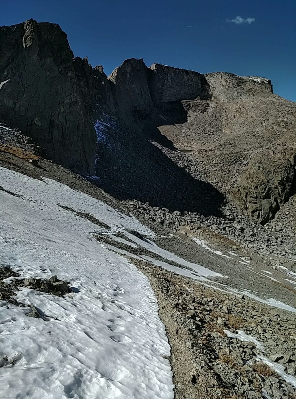
- The climb up Hailey Pass and Lower Twin Lake.


- Upper Twin Lake and Hailey Pass.
Lower Twin Lakes was not Lost Twin Lakes, but it was nothing to get excited about, being more of a pond surrounded by rocks. Upper Twin has more to commend it, though at our time of day, the best view was had from the other side, so we kept struggling up the pass. A group of 8 NOLS kids walked past with their shepherds and they looked entirely defeated. Given how much money NOLS costs, I suppose that once you’re in it, you’re not likely to give up! The NOLS course for the Winds covers 100 miles of backpacking over the course of 30 days, whereas I typically cover 100 in 8-10 days, so their pace must mean that they’re staying at the same campsite a few times. Or at least that’s what it seems to me. Of course, they also insanely use 80-110L expedition packs that weigh 40-50lbs, so they all have the backs of mules and the legs of elephants, I assume. Where was I? Oh yes, a group of young people with the faces of sadness and the backs of mules and the legs of elephants stumbled past us.

- To my mom’s left in the last picture is the area that we climbed to get to Pyramid Lake.
And then before us was Hailey. This pass was sketchier than I’d have liked! Although not scary based on sheer falls, it consisted of steep, loose, small rocks and debris, interspersed with snow fields, and much of it was beginning to melt under the post-noon sun. Before we found the actual trail down, our chosen path kept dislodging rocks, sending them tumbling down the mountain 800 feet, and sometimes the scree would start to slide with us on it. I’ve been on a chute of scree that entirely gave way, and was saved by managing to jump to some cliff ledges and hold myself there with my arms while the rock avalanche passed. That happened when I was younger and hiking by myself, but it sure put the fear of God in me!
Also during the descent, my knee began to form a subdermal hematoma and hurt like the dickins, which had become a common occurrence for me after the disaster I had prior to Shannon Pass. (This persisted for over a year.)


- Hailey Pass and Mount Hooker.
Given that we had places to be, we hoofed it and were to the base of the Hooker in under an hour, which pictures can’t do justice. It’s an 1800′ vertical slab (IIRC) that commands one’s attention. Absolutely worth the trip. From our position, we could see the creek coming out of Baptiste Lake, but given that we wanted to fish in Pyramid Lake and needed to go all the way back up Hailey, we didn’t have time to go up there and screw around. I’ll do it one day as part of a longer journey. We also independently noted Pronghorn Peak, which I later chose to visit simply to be captivated by the look of it.
I’m super proud of my mom, who handled the climb back up Hailey in a blazing 22 minutes! Going up was much easier than going down, and from the saddle we climbed the grassy hill and a few ledges up to what I’ll call Pyramid Pass, as it’s the saddle between Pyramid and Hooker. Navigating to Pyramid Lake is an utter breeze, though you do have to make your way through some Krummholz trees as you near it. We got brief cell service and let our families know that we were ok, and then, overlooking Pyramid Lake and Midsummer’s Dome (what a cool name), we reflected on the church couple that had led us on this adventure. How blessed we were.


- Climbing down to Pyramid Lake. Notice Midsummers Dome!
Pyramid Lake was incredibly charming and seemed quite dang deep. We found areas with sandy beaches, large, open meadows without rocks that needed to be moved, and even some tree stands if you’re the sort that likes a windbreak. Although I fished for quite some time, I didn’t get a single bite, and neither of us saw any fish, so after about an hour we gave up and made our way along the east side of the lake, crossed the easy outlet (rock hopped!) and found the trail to Mays Lake, which is well established and follows the drainage down to Mays Lake, which is only half a mile away and 200 feet lower.


- Outlet of Pyramid Lake, Mays Lake, Mays Lake, looking back toward Mays Lake; looking toward Shadow Lake.
From there we crossed the Mays outlet and picked the trail back down to Washakie Park, encountering not a single person during the drive. I caught a number of fish at Washakie Park, but as darkness fell, we scampered back to camp.


- We spent too much time at Washakie Park fishing.
Our camp was intact with no bear prints, so we made dinner (MREs this time) and got water, before bundling up for the cold night. The evening was pretty, though not as dramatic as the previous one. We both slept well with our hats!


- Our second sunset! Lucas of Arabia.
Day 2 totals: 11.4 miles, +/-3049′, 9984 min/ 10481 avg / 11418 max
⤑Day 3: Egress

- Just before we smothered her for good.
The morning was around freezing with slight bits of ice on the still water in the shadows. We had both packed up by 0844 and made our way back via the inlet creek that I mentioned from day 1. I didn’t realize how close we were to the Hailey Trail, so we broke off and went up a hill and through the forest after about 1/3 of a mile, finding a couple more little ponds hidden in the forest before stumbling back out on the CDT.

- The other trail was technically in view here. We just didn’t know it.
The return was uneventful: we spotted a marmot at Marms Lake, which ambled down to meet us, looked at the spawning fish in the creek between Marms and Dads Lakes, and at the south end of Dads Lake we spotted a very large bull moose, which we wisely avoided!

- The dang moose.
On the way back we visited Divide Lake, which is just off the trail before one starts heading down to Meeks Lake. I thought that it would be terrible, but there were plenty of trees, a nice outlet stream, elk bugling in the trees, and even fish! I truly didn’t expect the fish, and they made me happy to see. I think that Divide Lake is probably the shortest <8-mile hike one can do in the Winds…that’s worth it, at least. I thought that I took a picture, but apparently I didn’t. Shoot! Well, it’s worth the 15 minutes to bag the lake, anyway. (Unlike V Lake, Diamond Lake, Long Lake, Clear Lake, etc.)
We got back to our vehicle fairly late, at 1330, having spent time fishing. The trailhead was pretty empty, and we were both pretty happy with the hike.
Day 3 totals: 8.8 miles, +738/-1647′, 9097 min/ 9745 avg / 10069 max
➤Conclusion and Rating
Seeing the Hooker was a blast, and the ease of this outing made it very enjoyable. Since it stays along the “front” of the Winds for much of the time, it doesn’t have the most spectacular scenery. I’d still do it again any day of the week, however, and as a 5-day with exploring around Baptiste, it’d be a real contender.
- My scientific rating system. I liked this hike!
- Beauty. Mount Hooker is worth the trek by itself, but Midsummer’s Dome was what captivated me the most.
- Camping spots. All over.
- Crowds. This is not the most popular trail (Hailey), so it’s not too crowded.
- Difficulty. Moderate up Hailey, but the rest is just walking.
- Fishing. Lots of brookies!
- History. Not so much.
