Review: 14 Miles Hiking Sweetwater Gap Lakes, Wind River Range
The unnamed lakes in Sweetwater Gap are worth a visit given how easy they are to access, as well as just how surprisingly pretty you’ll find them. I didn’t see any fish there, but it was late in the year. (Status: Not yet proofread.)
➻ Quick Facts
Info at a Glance
- Time of Year: 16-17 October
- Notable Features: Larsen Creek, Sweetwater River, Lake 10624, Lake 10770 (Sweetwater Gap Lakes), Mount Nystrom
- General Route: Sweetwater Gap Trailhead (I consider this to be the actual trail start to Little Sandy, as the Little Sandy Trailhead itself is effectively inaccessible unless you have an OHV), Trail 370890 Continental Divide Trail, Sweetwater Gap Trail 7097, Off-trail to Sweetwater Gap Lakes, return via reverse route.
- Total Miles: ~13-14.
- Elevation Gain/Loss: +/-2734
- Elevation Min, Avg, Max: 8825, 9617, 10795
- GaiaGPS Page for GPS Track Download Grab a free Gaia account to download the GPS file for your phone or Google Earth.
Interactive GPS Map
Elevation Profile

⤷Introduction
Shocking as it was after our trip over the Tetons, the next weekend was looking to be a real stunner, with clear skies, light winds, and temps in the 40s and upper 50s. Mom was dying to hike again. I’m always dying to hike, and I love my mom, so of course I was game if my wife was down for me being gone on Sunday and Monday. Given that I would have had to travel to Rock Springs to fetch our winter stuff anyway, this allowed me to pay my mom a little to haul the stuff up and transfer it to the Jeep, and I got to spend some of Saturday after work with my wife and kid.
Our options were very limited for a number of reasons: the days would be very short, the trailhead needed to be close to my mom, and we only had one night available. Factoring in all the trails we’d already done, we were left pretty much with Sweetwater Gap Lakes or the Frozen Lakes. Sweetwater Gap Lakes would be the only option which would be basically new to us (i.e., not re-covering old ground), so that’s what we elected to do.
⤑Day 1: Sweetwater Gap Trailhead to Sweetwater Gap Lakes
SKIP THIS PART IF YOU DON’T LIKE GROSS STUFF: In case you hadn’t read my Teton post’s description of the horror-illness bestowed upon me as a thorn in my flesh, the malady had only become worse. For the week leading up to the hike, I’d been having blood-tinged liquid from my sinuses coming out when I’d bend over, lay on my back, etc. Sometimes the liquid was very proteinaceous. You’d think that having spent $84,000 removing bits of skull would have completely fixed such issues for me, but you’d be wrong. After this hike I ended up dislodging some massive blood clots from my sinuses over the course of about 5 minutes, and for whatever reason I then rapidly recovered.


CONTINUE READING: Mom didn’t think that I’d get to our meetup spot in time (the campground before the road up to Sweetwater Gap Trailhead), but I got up early and made the long drive there, arriving just before 10AM. Mom didn’t get there until 10:30, and then we drove up to the trailhead. Although still treacherous for many vehicles, the road was far better and shorter than I remembered. We arrived without any problems at 10:50 and parked by the only other vehicle there. By 11:05 we were on the trail, hiking down to the fork and then crossing Larsen Creek, which was filled with brookies.


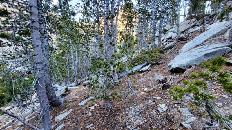
The Sweetwater Gap Trail ascended through rocky terrain surrounded by the detritus left by and old wildfire, but it was fine enough for walking. Of course mom started trying to do business, as she does, causing us some amount of delay. I used the time she was talking to her clients to nibble on food and look at the rather ugly surroundings. Hopefully it would get prettier.


We climbed gently for about 2 miles only ascending 400 feet, but the lack of anything pretty made it seem longer than it was. Just after two miles we came into near-contact with the Sweetwater River. The trail often passes little pothole ponds and lakes, and sometimes crosses over streams that aren’t on the map, while creeks which are listed sometimes don’t exist anymore. In general there are plenty of opportunities to get water, but the Sweetwater River is the best one. If you’re using the old USGS maps, the trail is now wildly divergent, by the way.
Below: Sweetwater River, a small stream not on the map, and climbing through boring forests.


2.5 miles in the trail climbs for a bit through pine forests and then levels off by a lake. It goes up along an area infested with boulders, and mom and I were convinced that this is to avoid the marsh. The up-and-down is probably worth avoiding soggy going; we both wondered if back in the 50s the marsh used to just be a field.
Below: The scenes along the trail.


Despite being sick, leaking from my face, and feeling like I’d been beaten with a brick across my sinuses and lungs, we made decent time. The blowdown in this area wasn’t too bad, and just after 2PM we stopped at the Sweetwater River again to drink water prior to our climb to the lakes. I desired to start the climb at mile 4.3, following the creek up. Note: the creek splits apart at 98xx’, but we were taking the first branch up. As we drank water, we saw an injured brook trout. The temperature in the shadows as very, very chilly, and drinking the ice-cold water didn’t make help much.


Although we started the climb at mile 4.3, in retrospect I think that going in the way we came out would be easier. In order to start uphill, we had to cross a tiny creek, plow through some dense forest and brush, and then cross the raging creek (yes, there are just creeks here and there, totally willy-nilly) on our way up. The side of the hill was very steep, and the ravine the creek inhabits is a no-go. We made our way up the hillside, climbing over downed trees, and slipping on the exposed dirt. There seemed to be some animal trails to follow, and we even saw a footprint as we got up toward where the creek splits apart. Out of curiosity, we listened to some Russians discussing the war on the way up. They weren’t very pro-Putin Russians (having left Russia when young to live in the west, but then having tired of the west and returned) and they had unexpected belief sets, at least to me. Of course I have a Ukrainian friend who also holds beliefs about the war that would seem strange to us Americans.


About 9850 feet the creek divides (or merges, as you head uphill), but the area downhill is rather wet. We stuck to some rocks and then crossed, after which we started the steep uphill grind again. Around 10200 we leveled off at a very scenic little pond. The area around it was dying to be camped at: gentle grasses, completely flat, large boulder slabs to sit on, nice trees—it was just very pretty. Yet me made our way around the pond and started climbing up, avoiding the boulder-strewn ravine in favor of the hillside.


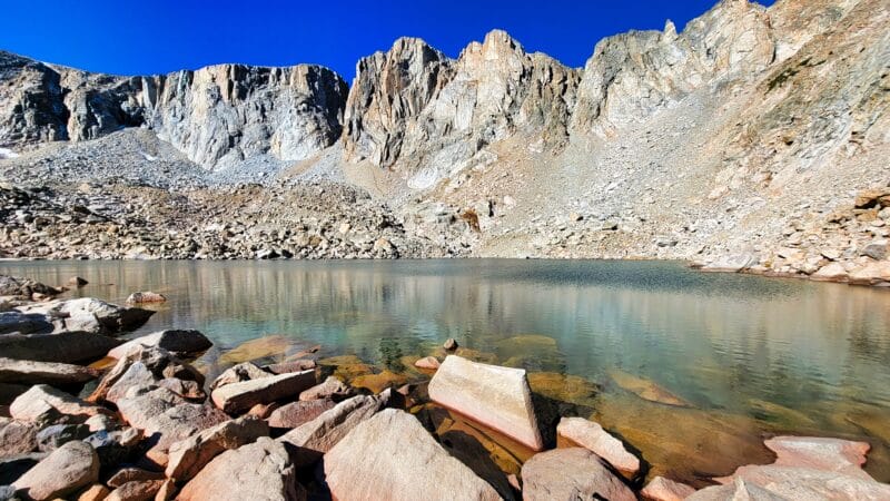
Just below 10300 we got a good view of where we’d need to go up. Mom found it pretty intimidating and was upset by the cold (it was icy everywhere). It looked like we’d have to climb the steep rockpile from where we were, as to the north the ascent appeared near vertical. We kept going though, just to see what it turned out to be, and to our pleasure the vertical appearance ended up being an optical illusion. Instead we found an easy, steep, grassy ramp, and smooth, granite slabs to walk on.
Below: Leading up to and climbing the final segment.


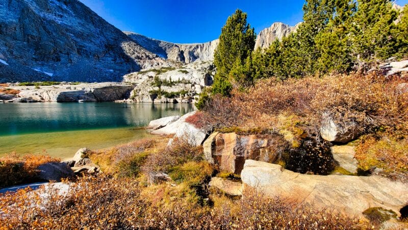
When we finally arrived at Sweetwater Gap Lakes (just before 4PM) the views were stunning, though we had to navigate a little side-pond and a slew of tiny trees to actually get to the lake. The cirque is just gorgeous, so I’ll let the pictures talk for themselves. After being awed, we set about trying to find a nice spot to place our tent. There were many options to chose from and we eventually settled on one that was tucked away in a little hole in the trees. I started gathering firewood so that mom could get warm, and mom went and collected water.


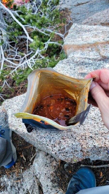
For dinner, I had Alpine Aire’s chili. It was awful, being more of a watery soup with no flavor, but tons of heat. There was simply no redeeming the meal. On the other hand, the cinnamon apple crisp by Alpine Aire was quite good. After finishing dinner, I went to take some pictures. The sunset was gorgeous and we were visited by some ducks who didn’t mind the cold.
Below: Evening scenes.


⤑Day 2: Hike Out
The night was incredibly cold and featured a bright moon which woke me up a couple times. We got up around 8, but I didn’t leave the tent until 8:30. Everything was frozen, but we were able to make a little fire and heat up some water to warm us up. We were also positioned to soak up the sun. I had hot chocolate, some chips, a snickers, etc., and then we moved the tent and our sleeping material up to a rock to dry. The condensation from our breath had gotten everything fairly wet as it froze so quickly.


We left camp at 10:30 and headed to the upper lake. It was an easy walk, though using the granite knoll would probably have been better than all the rock hopping. (You’ll know the knoll if you go.) The upper lake wasn’t even close to being as pretty as the lower one, but it was worth the visit.


There was no reason to stay long, so we made our way back to camp. On the way there we observed a nice camping spot by the knoll. You wouldn’t have as nice of a view of Mount Nystrom, but you’d be able to see Roaring Fork Mountain very well. We packed up and headed back toward the Jeep at 12:20.


On the way to the trail we went north rather than south from the little bench, aiming for two lakes/ponds. It was 1.1 miles to the trail from the lower lake, during which time we’d descend just over 700′. This way was very pretty and far easier than the way we’d ingressed. The upper pond was quite attractive and had great views of the mountain. I listened to some tabletop gaming podcasts on the way down.
Below: Walking down to the trail the easier way. In the first photo, the gash is how we came up. The last picture is where we came back out to the trail.


When we got back to the trail I looked for one of the benchmarks listed on the map, but never found it. About a half mile later and some 400 feet lower, we passed where we’d gone up originally. We both agreed that it was much harder that way.
As we walked out, we talked about church and something upsetting that Dave Ramsay had done (no offense to his fans, but we both think that Clark Howard is a better person and more honest), found a benchmark that I hadn’t been looking for, saw a grouse and a split tree, and enjoyed being family. We arrived back at the Jeep at 4:30 to find that it was a balmy 54 degrees.


➤Conclusion and Rating
For such an easy hike, I was shocked to see such beauty. Not many people seem to go to the area and it’s certainly worth a visit. The only downside is that I don’t believe the lake has fish, but as I didn’t fish, I can’t be certain.
- My scientific rating system. This was a very enjoyable jaunt with few downsides.
- Beauty. The cirque is just killer.
- Camping spots. Tons.
- Crowds. We saw a footprint.
- Difficulty. Relatively easy for your average hiker.
- Fishing. Brook trout in the stream. Unlikely in the lake unless they stock it.

2 thoughts on “Review: 14 Miles Hiking Sweetwater Gap Lakes, Wind River Range”
You are good at finding such beautiful places that aren’t so popular like Cirque of the Towers. I get tired of looking at those images. I hope you don’t mind if I go in and photograph some of them that have not been photographed much. If you are interested you can look at my website at http://www.definingthelight.com. I really want to add some Wind River images to my site. Gotta get it done before I’m to old. Great job! Any suggestions on other unlisted places with some great scenery would be great. Thanks Lucas!
Dean, I am beyond flattered and humbled by your comment. I am mostly a button clicker of Samsung phones and wish I did a better job capturing the scenery, so I am very excited that you are fulfilling that part! (And it looks like I really do need to get up into the Crazy Mountains at some point!) And of course I like Him to Whom you deliver the credit. It’s good to see someone influencing culture in such a way, and it looks like we took a similar approach to our naming conventions.
As far as places that are less visited in the Winds, luckily the Cirque and Titcomb (both just fine) absorb a ton of the visitation. I really think that your skills would make Middle Fork Lake (as taken from Bewmark) shine, and hopping over Kagevah Pass or Photo Pass is worth it. A number of places don’t get much visitation, though: Cathedral and Mendarrin Lakes (amazing), Stough Creek Lakes, all of the Roaring Fork up to Crescent and over to Faler Lakes (but that hike is an abomination), etc. Anything in the middle of the range on the eastern side of the divide is effectively untouched, of course.
If I had to pick a “must do” hike and I also had good photography skills, I’d absolutely do Middle Fork Lake and make the climb to Bewmark, though. It looks like Middle Earth from up there.
God bless,
Lucas