
Review: 9 Miles or More to Jim Creek Lake, Wind River Range
Jim Creek Lake avoids all the attention that the rest of the Wind River Range receives. Should it? And can you even get to the trailhead given the terrible roads in the area?
➻ Quick Facts
Info at a Glance
- Date of Visit: 14-15 August
- Notable Features: Jim Creek Lake, Lake 10729, Lake 10620
- Total Miles: ~9 if you just go to Jim Creek Lake, but we did 13.2 for sightseeing.
- Elevation Gain/Loss: +/-3935′
- Elevation Min, Avg, Max: 8379, 9571, 10991
- General Route: Jim Creek Trail
- GaiaGPS Page for GPS Track Download Grab a free Gaia account to download the GPS file for your phone or Google Earth.
- Images: I deliver pictures via a CDN at low quality to save space and increase speed. Feel free to contact me if you’d like full-size images for whatever deranged reason.
Interactive GPS Map (Click to See)
Elevation Profile

⤷Introduction
NOTE: NOT PROOFREAD YET!
My dearest mother wanted to do a quick hike and my beautiful wife wanted to go, too. I suggest Crow Creek Lakes abeam Afton as it seemed a good, entry-level overnight, given that my wife had never done one of those. Unfortunately, I mentioned to my mother that I was saving Jim Creek Lake for myself as something to do later on, so naturally she requested that we go there instead. I was resistant to this given that there was exactly one, very old picture of the area online, and the drainage had burned in 2006. From what I could tell, the ingress road had been destroyed at the Jim Creek crossing, and the only mentioned I could find of the trail in a guide seemed suspiciously vague, but mentioned a lot of burned area and some deadfall. In the end, my mother’s desire won out, and my wife fell in step with her as the total mileage was potentially less.
⤑Day 1: The Intermittent Trails and Trials of Jim Creek
The weather was calling for heavy rain. Yurena and I were already packed, so we got in the Cheep Patriot and headed out for 40 Rod Road, where we planned to meet my mom around 10. The sky had a low, iron gray overcast and the temperature was only in the upper 40s. Worse yet, the ground was utterly soaked from the rain we’d been getting over the past week. I hoped that it wasn’t going to be that way the whole hike, too. We brought rain ponchos just in case.


On the drive, we stopped by the store in Hoback and picked up some snacks and drinks, got gas, subsequently declared bankruptcy, and continued on, arriving at the meetup place a little before my mom. From there, mom loaded in the Jeep and we made our way to Jim Creek road. We were blessed by the overcast having topped out at Rim Station.
The road wasn’t terrible, but you’d only want to attempt it with a high-clearance vehicle, and having thick tread would also be a big bonus. We made it up without any real niggles and came to Jim Creek, where the road was completely washed away, and utterly abandoned. I want to be clear: when I say washed away, I don’t mean that you can get across it in a lifted truck. I mean vegetation overgrowth, precipitous sides, and completely impassable. Here’s a video of driving through the clouds to Rim Station followed by Jim Creek Road. Sorry about my low production values.
With the river scouting done, I made sure that my pack was correctly weighted. My wife was going to be using our Big Agnes Insulated Q-Core SLX air mattress (rectangular with side rails), and I was going to use my brand new Sea-to-Summit Ether Light XT Insulated pad, which is mummy shaped. I hate how long the names are. I was carrying all of our food, storage, power, and pillows, but my little wife was helping out by packing her own Enlightened Equipment 0-Degree Quilt. I can’t remember what it’s called, even though I bought it for her. She also had a convertible down robe/blanket. Overall, her pack, including the weight of her Osprey, weighed about 12 pounds, which wasn’t too bad.
Leaving the Jeep, we immediately crossed the river on some downed trees, then headed in on the old road.

The road itself was quite easy to walk, though it had a number of annoying springs that threatened to soak our feet. Some part of me wondered if I should even care given the hydroloading of all the plants we had to walk through; despite putting water repellent on our shoes, it was clear that we were going to get wet.


We meandered in and out of shade as we climbed about 400 feet over 1.5 miles. Just short of 1.75 miles, the trail obviously went the wrong way, heading up toward Kendall Lakes and into the burn. I knew that we needed to hang a left and cross the creek based on my map, but the trail wasn’t really visible; as it would turn out, it’s really most visible during the egress, as everyone can spot it from the opposing hill, whereas walking in, people must realize at various points that they’re slightly off, preventing a defined path from forming. Or something. Who knows.


Anyway, we picked up the trail just shy of the creek. One set of old footprints was visible going in, and zero going out. I hoped we wouldn’t have to spend the night by someone, but the tracks seemed a little old. In fact, they were almost all skid marks where the poor guy was sliding on mud. Thankfully for us, the sky had cleared and was drying things out. Less thankfully, the sun was just starting to get its bake on as we were about to enter some steep uphill without any shade.
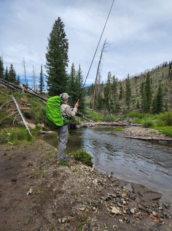
The creek was murky from all of the runoff, but I fished anyway. (Lots of fish in it.) We collected water which tasted strongly of the runoff, much to my displeasure. My dear wife didn’t care and chugged it down. Eventually I crossed the creek on a logjam, while my mother and wife took off their shoes and went through it directly. I hate removing shoes, socks, etc., so I go to great lengths to avoid it.

Past the crossing the gals stopped to put on their shoes, and my mom taped her feet. Yurena chose not to. The trail then climbed through tall grasses and around deadfall. We lost it 1000 feet in (hint: look over your left shoulder) and ended up going through springs in the grass and scrambling uphill through downed logs. Apparently this isn’t too uncommon, as we came across a sad little use trail which thankfully led us back to the proper path. From there we continued uphill, sometimes crossing very well worn trails that must be from cows and other creatures, because they didn’t seem to be heading anywhere that humans would want to go. Observe below:

As we made our way through the blazing sun, I eyed (not to be confused with the creepy, long-fingered lemur indigenous to Madagascar) the Kendall drainage across the valley. Significant deadfall was present along with more burn, but there were obvious ways to avoid significant portions of it. The area out of view concerned me, as I was scoping out ways to make Jim Creek out-and-back into a Jim Creek/Kendall Creek loop trip instead. It was something I’d be willing to chance myself, but not something I relished getting divorced over, so it seemed like something I might save for later.


Around 2.5 miles in, we’d gained over 1000 feet, but the girls weren’t feeling awful, which had me feeling great. We entered a pretty section of aspens where the trees had been trimmed in such as fashion as to create hidden stumps of stumbling. I’d never tripped so much in my life and was absolutely not a fan of this method of trail upkeep. I kept imaging my little Peruana fish wife falling and impaling her neck on one of these awful punji sticks. I was happy when we finally cleared them and broke out into an area below limestone cliffs.
Below: punji area and washouts.


The limestone area reminded me strongly of my hike to MacLeod Lake and had similar washouts and loose rocks. We put the area in the rearview mirror rather fast (with the exception of a brief delay as my mother got 4G and started doing work on her phone because, “Honey I can’t leave this $7000 on the table!”) and rounded a prominent bend where we got to see an incredible washout feature about 200 feet below, as well as four of five canyons which comprise the Jim Creek drainage area. Jim Creek proper has one canyon to the north and one toward Kendall Creek which enter it. Another canyon exists between Kendall and Jim, but it remains out of view as you climb.


About 10 minutes after spotting the washout, we we came across the arroyo which led down to the alluvial fan. It was very cool in its own right, and quite deep, so we went uphill until we found a place we could cross. For whatever reason the trail didn’t continue on the other side. As we’d find out coming back, it was another situation where the trail was visible from one direction only, and disconnected. In this case, the rest of the trail was about 100 feet lower. Go figure.


The burn was easy to navigate and some cumulus towers were forming. The blessed provision of intermittent shade was quite the boon, and my mom and wife cheered up when I showed them on the map how close we were to Jim Creek Lake. We could see the creek in a pretty park below us, and it snaked up to a large rock pile, which concerned my mom. From the area above the creek, it indeed appeared that the trail was going to be very vertical or lost in rock piles.


I was able to spot the trail again in the field, so we scuttled down to it and soon came across Jim Creek. Here we stopped for drinks and snacks, and watched a few jets zip overhead inbound to Jackson on the RNAV 01 X approach. In the summer months, that’s typically indicative of convective activity over the Teton valley. My mom and wife thought that my little bug gummy looked like something indecent.

Crossing required the removal of shoes, but the creek was quite tame, other than being absolutely frigid. Soon we found ourselves climbing up switchbacks mostly in shade. The zig-zagging trail was quite steep and a bit scrabbly, but after 400 feet of vertical gain, it mellowed out and followed the creek through denser, lusher forests. The bugs weren’t bad for me, but they did like my wife. As her blood tests indicated when we had them done, this is a known inconvenience which she is forced to endure.


From the top of the switchbacks, it was only half a mile to the lake. Unfortunately, springs invaded a good portion of the trail and used it for their rivulets, which made staying dry (and mud free) quite difficult. I managed it better than my wife and mom, but didn’t escape completely unscathed. A huge rock spire/gendarme was visible in this last section, so we stopped to get pictures with it. I was also happy to find some true fir trees, which are easily identified by their cones, which stand upright on the limb rather than hanging down. When I was young, I used to refer to them as elf eggs, which is a bit strange as according to lore elves are mammals.


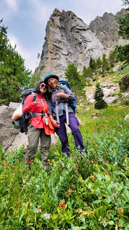


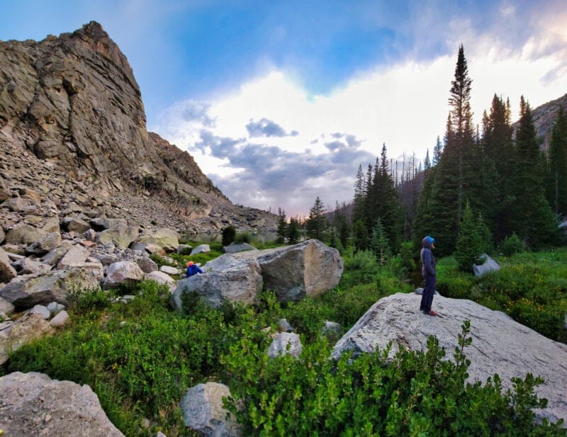
Finally we made our way through some large boulders and up a small crest, after which Jim Creek Lake popped into view. The lake isn’t very large, but it really is beautiful. On the trailhead side of the lake there are a few places to camp among massive boulders, but the entire area is tightly constricted by the terrain. It’s unlikely that you’ll find a spot 100-200′ from the creek or lake to park your tent, but the blessed thing about the area is that it seems to receive almost no visitors, so your presence is unlikely to cause a disturbance.


We all took our packs off so that we could search for the best place to put our tents. The clouds were becoming menacing and a chill wind had started ripping downhill, leaving my pobrecita quite cold. She opened our bags and grabbed some snacks, but otherwise sat down and avoided the wind as my mother and I searched for a good camping spot. We ended up settling for the east end of the lake, which allowed us to stay farther away from the trail, and also had flatter spots. Most important to my mother was relative lack of wind compared to the outlet side.


Our chosen campsite was close enough to the stream that we’d get to hear its burbling all night, something which I have always appreciated. Camp setup didn’t take too long, but we did have to adjust my Copper Spur HV UL3 a billion times, as my mom wanted her Nemo Hornet to be abutting it, ostensibly to prevent a grizzly from making off with her in the night. Eventually she gave up on making it work, because she accidentally placed her own tent backward, and by that time didn’t think it was worth the effort to fix it. Our worry boxes can only hold so much.
After setup we started water for dinner. I’d brought my dear wife a Peak Refuel chicken and rice, which I adore. Or rather, I thought that I’d brought her chicken and rice. What I actually had in my pack was a Peak Refuel stroganoff. Coincidentally, my mother had purchased a Peak Refuel chicken and rice, and upon comparison, the images looked strikingly similar to the inattentive eye. Oops.
We made dinner and sat on a rock perfectly made for eating. Yurena liked her noodles and beef, while I also had noodles and beef, but in the form of Peak Refuel beef pasta in marinara sauce. Mine had actual GREASE in it, which is a delight to the soul when in the backcountry. Unfortunately, this grease wanted to splash and drip everywhere, making it something of a chore to eat. Still, it was absolutely worth it. For dessert we had the option of a snowball, a cherry handpie, or a chocolate cheesecake from Backpacker’s Pantry. Naturally we ate the cheesecake, which is far more chocolate pudding than chocolate cheesecake. Yurena ended up absolutely stuffed, so I helped her with finishing some of the food, then took her fishing with my 3.1 oz tenkara fly rod. Sadly I lost my fly, and even worse, it was my last one.


With the fishing done, we made out way back to our tents. My mom washed up in her tent and retired early, so we both cleaned by the fire. The mosquitoes didn’t bug me, but they did pester Yurena a tiny bit. As the sun was falling and the temperatures likewise, they weren’t nearly as bad as the Winds can throw at you.


Yurena got into bed a bit ahead of me, and then we put on a TV show for about five minutes. Yurena’s snoring was my signal that it was time to call it a night.
⤑Day 2: Viewing Kendall Lakes from Above and The Choice to Skip Them
Yurena and I both slept poorly. I woke up with a headache and she was very stuffy; we’d both had crazy dreams that had woken us up multiple times. One naproxen and 30 minutes later, I was feeling better, so we got out of the tent around 8 and discussed the day. Keeping in mind my wife’s limits and our need to be back home by 9PM, I suggested that we climb up to the top of the plateau and make our way over to Kendall Lakes, where we could scope them out and see if they’d be worth a future visit.


Though I hate O&B trips, it seemed wisest to me to avoid taking Yurena into some hellish deadfall and burn, and entirely off trail. She was just dipping her toes into the water, so there was no good reason to turn the temperature to scalding. I didn’t tell her this as the reason I proposed just doing a quick day hike up.
As we talked about it, my mom came down the hill where we’d put the food and apologized, saying that she’d gotten the bear bag stuck and that she’d buy me a new one. I asked how she’d managed that, and apparently it involved grabbing the rock sock and trying to loft it back over the branch. After I asked her why she didn’t let the bag down and just untie it, she blushed and muttered, “I’m sorry. I haven’t had my coffee and I was trying to get to it. I can’t think without my coffee.”
Fair enough. I went up the hill and managed to retrieve the bear bag without difficulty. Unlike my mother, I’d had some stimulants already. (Discursus: 4C Energy Rush Orange is a wonderful creation. It’s carbonated, really gets your mind active with a quickness, and tastes delicious. I shared it with some of my controllers, and one of them ended up buying it in a bulk variety pack as he appreciated how much it helped his focus. No, I don’t get paid for this, nor for Amazon links. And yes, I’ve used all the varieties of Celsius energy mixes, which taste like kerosene and don’t do much other than make me sick to my stomach.)
After a quick bite for breakfast, we headed uphill for the pass. A well-defined trail led uphill about 100 feet before vanishing into cliffy, bouldery hillside with intermittent cairns. We were at least in the trees, but the day was rapidly becoming much hotter than the previous one, and there wasn’t a hint of wind to cool it down, nor cloud cover to block out the sun’s harmful, hurtful smile.
The intermittent trails weren’t hard to follow, but I was somewhat worried that we were going to end up in the massive boulder field to the south. Thankfully that didn’t happen, and after hiking only 1/3 of a mile, we popped out into what my map labeled as an area with a lake. There was no lake, but a large, marshy, verdant field was present. Based on satellite images, I imagine that an intermittent pond forms during spring runoff. To the east we could see a trail going up a bald hill and into some trees, but we stayed along the base of Saltlick Mountain until we found a well-defined stream, which also seemed a good place to start making our way toward the pass. Another stream crossing presented itself, though it was not flanked by rocks and thus a bit sketchier to cross without stepping in marshy bits.


Following the crossing, we made our way to the trail, which appears somewhat out of nowhere a bit up the hill. The climb was rather steep, even with the whole two switchbacks, so we didn’t talk much. After 300 feet of climbing, we topped out at a little, valley-like feature that my wife found rather pretty, but there was no time to stop. The trail vanished, as was its wont, and appeared again inexplicably and with great clarity on the hillside to our right. We lumbered up with me offering assurances that we’d be near the top soon, and able to see a neat little lake just barely hidden from view.


Lake 10630 soon became visible, thought it was more of a pretty pond than a serious lake. If you were hiking through, it certainly presents a viable place to park it for a night, but there was clearly little reason to choose it over Jim Creek Lake. We all conferred and decided to press on toward Kendall Lakes, hoping to make a nice overlook where perhaps we’d be able to get their lay.

We soon crested a saddle and happened to see a herd of elk staring at us from a hillside off toward Green Lake Gadsby. They were rather curious, but eventually they gave in to their fear and took off, leaving us with only the beautiful views of the distant mountains. Though the area appears flat on the maps and on Google Earth, it features undulating terrain that takes one up and down hundreds of feet.


We elected to head toward Lake 10,730, which involved walking down to a stream crossing, getting some water, letting my mother answer work texts, and then climbing a few hundred feet up another hill, where we then angled to our right. The Beloved Ms. Necessary gave out and took a nap on a rock at 11,004 feet, while mom and I continued on until we could see Kendall Lakes.


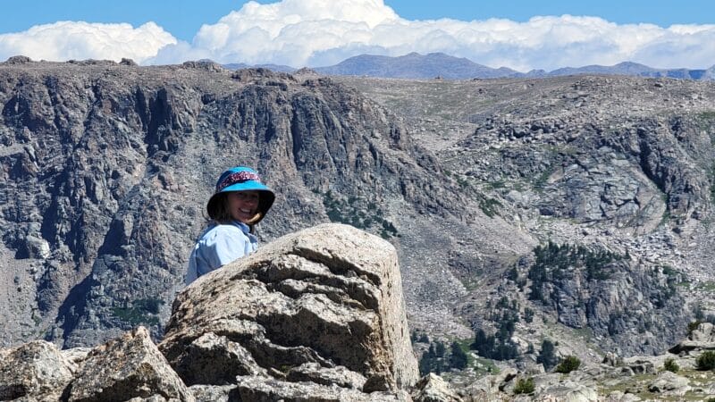


The walk down past them didn’t look too bad, and my mother kept speaking her praise of how pretty they looked. Not to disagree too much, but I wasn’t very impressed. We went back to Yurena and I took a number of photos of Gannett and the distant peaks. They were beautiful. Lake 10,730 was likewise quite attractive, though we saw no reason to go there.

It was around 12:30, and Yurena was worried that we couldn’t hike out in time, so we headed back toward camp. I assured her that it wouldn’t be a long hike going out, and we’d be fine as long as we hit the Jeep by 7PM.


We arrived back at camp before 2PM, which was a somewhat leisurely pace for only covering around 2 1/4 miles going downhill. Packing didn’t take very long, and by 2:30 we were en route to the Jeep.

At the creek crossing just before the burn I announced my intention to keep my shoes on. My mom protested, but eventually she agreed that it wasn’t too far out, and our feet were rather dusty and hot. Like I said, I hate taking my shoes off.
The walk was pretty easy, and we followed the well-worn path to the bottom of the huge wash, where it disappeared. After climbing 100 feet, we found the trail we’d taken in. By this point, like a junkie, it was this wont of the trails was tedious.


We once again survived the Aspen punji traps and made it back to where we’d found the trail after going through the marshes. As it turns out, plainly in view appeared the true trail out, though it appeared to get lost in the burn. We followed it and it took us easily to where we’d first lost it. Again. Junkies. Tedious.

My wife was complaining about blisters at this point, so I offered to tape her feet. She declined, despite my mother also urging her. Spoiler alert: she never got blisters.
Following the creek crossing, we rejoined the old road and made our way down to the Jeep. My wife was very silent and kept falling back. I thought she was angry, but it turned out that she had come down with a bad headache. I offered to carry her pack, but she declined. We crossed Jim Creek a last time and arrived at the Jeep around 5:30, giving us plenty of time to wash up using my camp shower, though my mom, being a got-dang lunatic, went and washed up in the freezing creek.


We dropped mom off and made it back to Jackson, where I unloaded as Yurena took her Juke (a vehicle of indiscernible purpose) to get our little kid.
➤Conclusion and Rating
Jim Creek Lake is actually a dang good hike for how short and unused it is. It also doesn’t take a long drive, has some nice geology, and plenty of fishing. We were quite happy with the bang you get for your buck. You can do Jim Creek Lake in about 9 miles round trip.
My over/under is:
Over: Gypsum Creek Lakes. Around the same distance, prettier, and easier. Cooler all around. Downside is the road in.
Under: Blue Miner Lake. Around the same distance, way more effort on the legs, and a lot more crowded. Also less to do.
- My scientific rating system. I really liked this short hike.
- Beauty. The burn sucks, but the pillar over the lake is awesome.
- Camping spots. Not too many, but not too many are needed given how few people frequent the area.
- Crowds. None.
- Difficulty. Average intensity. Really not bad for what it is, but there is a lot of steep uphill.
- Fishing. Lots of brookies.
- History. Not much.
Let me know if you have any questions. I’d love to help you do more with that time of yours, and I’m here to serve you!

2 thoughts on “Review: 9 Miles or More to Jim Creek Lake, Wind River Range”
How did you get your wife interested in backpacking? I’ve gone on a couple trips with my wife, but she’s always resistant, as she’s afraid of animals while in the woods at night despite my reassurances.
Dan, my wife grew up quite poor, just like me, so I think we’re naturally pretty down with roughing it. That said, when we are hiking in territory with grizzlies, I bring my sidearm, too, and strap it to my wrist when we’re asleep, since a predatory grizzly will not be deterred by bear spray confined to a tent, and it will just incapacitate us. Other than that, we don’t have any reason from a risk-analysis standpoint to have any fear of the wildlife, and with our satcoms and helicopter insurance, we’re really pretty set these days.
I also bought her very nice equipment and sleeping gear, so combined with the good food, it’s enjoyable for her. This was probably her least favorite hike as she got a migraine.