Review: Up, Up, and a Day Hike to Blue Miner Lake & Sheep Mountain
Blue Miner Lake and Sheep Mountain had great views, but were they worth the interminable, waterless climb?
➻ Quick Facts
Info at a Glance
- Date of Visit: Early October
- Notable Features: Sheep Mountain, Blue Miner Lake
- Total Miles: ~15.0
- Elevation Gain/Loss: +/-4975
- Elevation Min, Avg, Max: 7008, 8589, 10296
- General Route: Grizzly Lake Trail, Blue Miner Lake Trail, Off-trail (unofficial trail to Sheep Mountain), Blue Miner Lake, return.
- GaiaGPS Page for GPS Track Download Grab a free Gaia account to download the GPS file for your phone or Google Earth. It’s under the “data” dropdown.
- Images: I deliver pictures via a CDN at low quality to save speed and increase speed. Feel free to contact me if you’d like full-size images.
Interactive GPS Map (Click to See)
Elevation Profile

⤷Introduction
Due to a late start, a foot injury, etc., I’d not been able to explore Blue Miner Lake the previous week. The weather was holding out for early October, though, so I contacted my mother and she drove up to do a day hike of the lake with me. She was recovering from COVID, and I was mostly over my walking pneumonia, so we figured that the elevation gain on this trip would really sort out just how healthy we were. I packed some stroopwaffles and some really good “beef jerky” for the trip.
⤑Day 1: Day Hike to Blue Miner Lake and Overlook of Tetons

We couldn’t leave as early as we’d have both liked, as I had to drop off my kid at school first. On the way, we decided to grab breakfast at a fast food place. 37 minutes later (ugh, Jackson), we had food in hand and were on our way. We decided to stop by the Crystal Creek bathroom first, and then drove to the pulloff just west of the trailhead, as we were going to use the western lead-in for better views. (Detailed during my egress of Grizzly Lake.)
- Slide Lake area, showing the slide.


We started the hike in at 1030 and enjoyed the views. The temperature was a bit warm (upper 60s), and we knew that we’d have no water for most of trip, so we planned to stop at the last creek crossing before the continuous uphill to get a drink.
- Pull off parking, views of the trail in.


The trail in is annoyingly rolling, with prominent, bridged creeks at miles 1 and 1.5. At the 1-mile crossing, we saw what looked like some sort of camp, and it seemed in an odd area, but just beyond a bunch of extreme trail work was evident. This trail work had been there to a lesser degree the week before, but it was much more complete now. We figured that the trail crew was probably from a white van, which we’d seen at the trailhead earlier. What their intentions were with the work still isn’t clear to me. It was also strange that it started a mile in and didn’t go far.
- Views on the trail in, the trail work, and the trail crew. Plus a C130. Gross!


Regardless, we made our way up the hill, enjoyed some fall colors, and then went down the next hill, coming to the second bridge; immediately past it, my mom hid one of her water bottles that we wouldn’t need. We both drank a bunch more water, and then loaded up with about 40 fl oz for the trip up. From there, it was one more crossing, and then up, up, up, with nice views of an old cabin that a trail leads to, and apparently goes past.

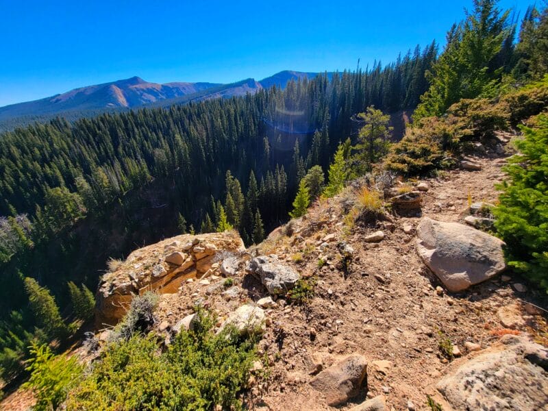
Before long, we reached the junction to Blue Miner Lake, and there we began the annoying slog uphill. It’s not too bad, but the first couple of miles probably average 800-900 vertical feet/mile, and if it’s warm, you’ll feel the tediousness of it all. Around 3.4 miles into the trip, the trail really travels along the ridge, and often within feet of very long falls. My mom is scared of heights and wished that we didn’t have to be so close to certain death. As long as you don’t trip on a rock, you should be fine, though.
Walking along the cliff, we noticed a well-defined trail along the prominent creek about 500 feet below. Mom was of the opinion that we should have taken that trail, which she’d hinted at on the way in. I wasn’t so sure, as it was unlisted and, in my estimation, probably terminated at rock fields that would go on for miles. Still, the creek was pretty, and there would have been plenty of places to camp. Since we were going to Blue Miner, most of the elevation gain would have to happen regardless of which way we went. Although I’m still uncertain, looking at satellite imagery, it seems like one would have a battle against about 2 miles of non-stop boulders toward the upper drainage.
- Views during the climb along the ridge.


3.5 miles in, there is the slightest bit of downhill, and then it’s back to the march heavenward, for another mile (we stopped to eat some food during this part), at which point you exit the forest and enter some gentler-grade climbing through fields.
- Red hills and red jerky!


Hoping for a view of the Tetons, around 5.5 miles into the trip, we struck out west. That was a wasted 1500 feet, because views there weren’t. Hoping to salvage it a bit, we listened to the Tom Woods Show (boring name, but boy is it informative) and followed the contour lines around a little knob, then decided to climb a small hill that leads to a ridge overlooking Blue Miner Lake. Do none of this yourself. As it turns out, right before the trail descends to Blue Miner Lake, a use-trail to Sheep Mountain splits off. By climbing off-trail, we took longer, had less views, and generally gained more elevation than we needed. We did at least see a buck, however, and noted a fire. The fire turned out to be a controlled burn at Grouse Mountain. We also got to see some well-fed bear poop.
- The grassy area, Grouse Mountain controlled burn, Jackson Lake at low water, bear poop, a trail across rocks, oh, and before I forget, the lake that isn’t. More about that in the next paragraph.


Once we were at the top of the most prominent knob on the ridge west of Blue Miner, we decided to follow it to the use trail (which by that time we could see) and hope for an area to get pictures of the Tetons. It was late, but I was fine with hiking out in the dark if we needed to. My dearest mother once again commented on not liking the slope, but I was pretty convinced that we might be able to go straight down it to Blue Miner on the way back, if we had time. Looking past Blue Miner to the east, I saw that one of the lakes that you can see on Google Earth was a mere, dry, treeless spot at this time of year. My old USGS maps had listed it as a marsh, but the satellite imagery had convinced me that it must be an actual lake, along with a pond above it. I’d even planned on hiking to it and camping there the week before…without being able to see it from the official trail, I’d have hiked across a boulder hell, down 250 feet, only to find an old, dried meltpond. It was a blessing that I hadn’t gone.
As we continued along the spine, the ground changed into soils which reminded me of some parts of Georgia. I took numerous pictures. Yes, when you’re dumb enough, even dirt itself can keep you entertained. As we neared the high point we were aiming for, our view of the Tetons was blocked by trees and a little bit of terrain. We had the option of pressing forward around the belly of the Sleeping Indian (south), or trying to follow a small ridge to the west. Given the time of day and that we only wanted to see the Tetons, we just went westward. If it had been peak summer, I think that we’d have gone around Sleeping Indian some more just for the heck of it.


As we made our way west, the Tetons erupted into view. Jackson Lake was also incredibly low, which Tyler Perry’s chief pilot had remarked to me about just 5 days before. We got some pictures and mom sadly got cell service, so she went into her “making money mode,” which is the most difficult mode to reset her from. After spending about 20 minutes, scaring some bighorn sheep, and absorbing the views, we started back toward the use trail, but then decided to get a few pictures with the other side of Sleeping Indian.
- First gallery: find the bighorn sheep.
- Second gallery: looking at Sleeping Indian.


Shortly after, we made our way back toward the trailhead. It was something of a snap decision, but with only about 16oz of water left, we decided to make a quick trip down the hill to the lake. We departed the trail and tried not to fall down the hillside, which was ridiculously steep and quite treacherous. I was able to walk almost all of it, but in one place I did have to scoot on my butt so as not to die. It was not a pleasant experience, though also not deadly.
- Blue Miner Lake on the way down, and a very important spot for mom.


By the time we got to Blue Miner, the shadows were very long. The lake itself was gorgeous, though fishless, and quite low at this time of year. The colors were really the most impressive aspect of the whole thing…well, that and all of the rocks. Still, there were plenty of places for one to camp. I don’t think that I’d really go through that much elevation gain for a fishless lake with no water along the way, unless I was going to really make a time of exploring the Sleeping Indian, and thus would benefit from an overnighter.
As I was taking pictures, my mother let out a wail of agony. With darkness nigh upon us, she realized that she’d lost her phone. Gone. I asked her when she last had it, and she didn’t know. Back at the Sleeping Indian, but then she’d decided to put it in her open, butt pocket of all places. It could be anywhere back on the trail. We looked around in the immediate vicinity but found nothing. We checked in my pack and found nothing. We checked all of our clothes and found nothing.


Mom was wildly upset over losing it, and was beating herself up for her stupidity. It was relatively new for her, had all of her work information on it, and was a loss of $300. I told her that if she’d carry my pack and get water, I’d go back and try to find it, and then meet her along the trail, back in the big field where we’d tried to get the first overlook of the Tetons. She objected. It was too dark, I could get hurt, finding it was highly unlikely as we’d been off-trail, etc. I finally convinced her that it was worth me running back up. I’d keep the satcom and she’d keep the bear spray. While reluctant, she agreed, and I set off up the hill as quickly as I could clip along. It was a strenuous climb, but now that I was mostly over all the pneumonia stuff, not really that bad at all. I tried to remember how we’d come down, but it was difficult. My GPS had been polling at a low rate, and we hadn’t left much in the way of footprints. As I climbed, I doubted that I’d find it.
But then I did. It was sitting covered in dust on a very steep section of hillside, where mom must have slid on her butt. I was delighted to discover it! It was not broken and only needed a light cleaning. I said a prayer of thanks to God for finding it, because I hadn’t expected to be able to. With the prayer completed and joy in my heart, I went up the mountainside, angling toward the use trail, and scaring a couple of deer along the way. The sun was getting ready to set, but despite that, I took a few pictures. Then I intermittently ran and jogged to make up for lost time.
- Praise the Lord!


Eventually the use trail ran into a field, where it then petered out. This was the most treacherous (a word that I’ve used twice in a short period of pixels) part of the entire trip, as there were some sort of ground squirrel holes all over, nearly breaking my leg. I was glad to re-intercept the Blue Miner Trail.
- Climbing up the hillside while looking down on the trail that my mother must have used, views of Blue Miner, the use trail, and the second to last picture is where the use trail meets the official trail. See if you can spot my mom in one of the pictures.


Passing into a small sliver of forest, I saw my mother just ahead. She was using the Osprey pack’s built-in whistle, but I couldn’t hear it while I was running. She was delighted to see me and just as delighted to see her phone. She was also uncertain of where we were supposed to meet, so she’d just stopped at a random point. Good enough! I showed her where I’d found it and then took the backpack so that we could jog a good portion of the trail. We also drank much of the water that she’d gotten for us so that I’d have less to carry on the way down. Right before we took off, she told me that the trail from Blue Miner doesn’t have switchbacks as the map depicts, but rather just goes up at an angle the whole way.
While we jogged, we listened to a podcast on the history of the Waco slaughter, which was conducted by some relatively malevolent people. I don’t remember the episode number, but his show is located at this link right where it says, “click here.” Mom liked listening to the podcast, as it kept her mind off the gloaming transitioning to night, but she reminded me a few times that she wanted to be beyond the frightening cliffs prior to pitch blackness.


We mostly managed to accomplish that task, leaving the last scary area as all of the light faded. Given that it was dark and not going to get much darker, I told her that we should stop and eat the rest of the food. She was amenable to the idea, so that’s what we did. Then we continued back toward the Jeep, taking a cross-country detour in the wilderness prior to the switchback (the only one on the trail). The detour was quite effective.
- The detour.


When we got back to the trail-work area, we heard a great hooting-and-hollering, as if there was a real hootenanny going down, or perhaps a wilderness hoedown. It was the young trail crew, judging from the sounds and the light, partying by their tents. They became silent as we passed them, though there was no need for them to cut down on the revelry. After all, it’s a dark and scary world, and if you are as silent as a mouse, wildcats might find and eat you.
For whatever reason, after we passed them, mom became convinced that we were heading toward Grizzly Lake instead of the Jeep. Thankfully we weren’t, and we arrived back at the Jeep around 9:30. I was very happy to get to have done a hike with my mom, even if only a rushed day-hike.
➤Conclusion and Rating
Blue Miner wasn’t quite what I expected. It’s certainly pretty, and with no one else around, it was really worth it for me and my mom. With that said, my mom liked it less than I did. She considered it to be quite a lot of work for views of the Tetons that are, well, pretty much the same as the valley floor, and she wasn’t impressed with Blue Miner Lake, other than the colors. Given the amount of uphill climb, I’d say that overall it probably comes out about as pleasant as the hike to MacLeod Lake, which is also in the Gros Ventre. MacLeod doesn’t give one views of the Tetons, but it does have fish. On the other hand, MacLeod’s trail is much worse, but it also has water most of the way., and about 1,000 feet less climb.
- My scientific rating system. I enjoyed this hike, but probably wouldn’t do it again.
- Beauty. Blue Miner Lake is gorgeous, though lifeless, and the views of the Tetons are hard to beat, unless you’re down on the valley floor or anywhere else where they’re the exact same.
- Camping spots. Plentiful, but the destination really is simply Blue Miner Lake.
- Crowds. None, but this was an off-season hike.
- Difficulty. Strenuous. Lots of elevation gain. Pack water with you.
- Fishing. None.
- History. Nah.
Let me know if you have any questions. I’d love to help you do more with that time of yours, and I’m here to serve you!
