Review: Brewster, Lunch, & Shoal Lakes via Big Balls of Cowtown Trail
Featuring Lunch Lake, Brewster Lake, and Shoal Lake, this hike in the Gros Ventre received my highest rating. Use the included GPS recording so that you can enjoy the Big Balls of Cowtown Trail, which many people have a hard time finding.
In this post:
- ➻ Quick Facts
- ⤷Introduction
- ◕Prep Day: Camping Out at Shoal Falls TH (No Hiking)
- ⤑Day 1: Kinky Creek TH to Lunch Lake
- ⤑Day 2: Lunch Lake to Shoal Lake via Big Balls of Cowtown Trail
- ⤑Day 3: Shoal Lake to Shoal Falls TH
- ➤Conclusion and Rating
➻ Quick Facts
Quick Info
GPS Map of Hike—Interactive (Click to show)
You can visit the GaiaGPS page and download the link as KML or GPX if you’d like to follow along in Google Earth while reading. Sign-up is free and can be done via a single click with FB. Alternatively, you can contact me for the file.
⤷Introduction
With summer winding down and having just finished hiking to Goldbug Hot Springs with my new friend Beatriz, I was wondering if I could manage a trip over the Gros Ventre Range with my mom, Yue, or someone else. Beatriz said that she might be able to, but she was pretty uncertain. I tentatively planned a trip over the mountains with her, as I had plenty of loaner gear. She’s only about 4’11”, so she’d have to use one of my relative’s backpacks, but I knew that it should fit her. If she had to scrub like Yue did with Goldbug, I would instead do Lozier Lakes or one of the high lakes out of New Fork in the Wind River Range.
I had seen this hike on Eric’s Hikes; he’s a great guy with a blessed life. He hiked the area in a very different manner than I wanted to, but it sure looked beautiful. I told Ms. Beatriz that we should go from Kinky Creek up and over, since we’d save ourselves about a thousand feet of elevation gain—or more. From my estimates, we could do the hike in about 19.x miles, which I let Beatriz know about. Through miscommunication, she ended up thinking it was only 15 miles. We agreed to meet up on Friday evening, the 13th (spoooooky), hike only a very short distance or spend time at the trailhead that night, and then hike through, getting out on Monday the 16th. Overall, our actual hiking would be limited to the 14th, 15th, and 16th.

I also found information suggesting that we could manage the hike by going over something called “Big Balls of Cowtown Trail,” though Eric and some others mentioned that it might not be in existence anymore due to rockfall, or might just be incredibly well hidden. If that were the case, I prepped for alternatives. It looked to be a blast, even if stuff didn’t happen as I wanted.
Our general route would be from Kinky Creek on the north side of the range, to Shoal Creek on the south side of the range. There’s about a 1000′ elevation difference, and I’d rather descend more than climb. We were going to leave one car at each trailhead, which meant extra hours of ferrying, but sure beat having to pay $150 a person for a ferry service. I didn’t have a good map for this part of the range, but was very familiar with the topography, so along with my GaiaGPS, no physical map would be needed.
As an additional note, I considered taking us down near MacLeod Lake via a mountain traverse, but was worried about Beatriz. I didn’t want her falling to her death. MacLeod’s trail leads down to Granite Hot Springs, so we’d end at the springs and also see a lake. There’s a trail that also goes down to Granite which cuts out MacLeod, but then we’d miss out on a lake (Shoal vs MacLeod) to see something I’ve already seen plenty of (Granite HS). Now that I have done this trip, I do hope to see MacLeod in the future, and possibly on a similar itinerary, hopping over to it from Shoal Lake.
◕Prep Day: Camping Out at Shoal Falls TH (No Hiking)
Being Friday the 13th, things started off stupidly, though amusingly. I was running a little behind as there was road construction that simply had no movement for 27 minutes. Beatriz said that she could indeed do the hike, but that she was also a bit behind, so we elected to meet up at the Elkhorn Bar & Trading Post in Bondurant. I got there by 4:40PM, texted Beatriz that I was there, and waited. She’d texted me that she was leaving Jackson when I was stuck in construction, so I didn’t think that it would be too long.
I sat and waited for quite a long time, and then got a text from her saying that it would be a while. She’d daydreamed a bit and blown past the Elkhorn by a very long way, and was almost to Pinedale. Oops. Things happen, though. That meant that we’d just end up camping in the Jeep on the south side of the range instead of the north. Overall, losing a few hours of time was acceptable with the padding we had at our disposal.
Beatriz arrived around 6PM, and we decided to go shopping in the Elkhorn, since we wouldn’t be hiking that night. We got some snacks and drinks, and the kind young lass at the counter warned us about our ursine enemies romping around looking for late-fall berries. Noted, ma’am!

- Soon we’d be cresting that shield.
If you have already downloaded the GPS/KML I’ve provided at Gaia, you know how to access the trailhead. If not, take Dell Creek Road until you see a gated public recreation area on the left; it’s Riling Draw Road 30640. You’ll get to it right before you’d cross the river on Dell Creek Road. If the gate is closed just open it.
The road itself had gotten even more woefully rutted since I’d been there last, which is secondary to the fires that happened in 2016, when I was working the airspace for Jackson Hole. With my little Jeep, there were a couple of places that my first attempt to navigate the road didn’t work. On the final day when leaving to pick up my Jeep, poor Beatriz banged the crap out of her larger SUV, so I felt bad about that. If you’re in a low-clearance vehicle, just forget this avenue and use Granite Hot Springs instead.

- A good part of the road, but still lots of standing water.
We arrived at the Riling Draw site and there were a number of vehicles and outfitter tents given that we were going into hunting season. Beatriz and I discussed sleeping there, but I’d seen a road into the forest on the way up that might be better. We had plenty of water and drinks, and thus were in no need of being by the river. We reached concord on the matter and left her vehicle at the trailhead, and went off in my Jeep.
The side road led to a nice, burned out clearing with grass and a little bit of muck-pond in the middle, from which cows had obviously been drinking. It was level, though, and we had plenty of firewood to grab. Beatriz was worried about starting a forest fire in the area (which was burned to the ground), but I pointed out that everything was soaking wet from previous rains, that rain was forecast intensely for the coming week, and that there was no way for the fire to spread. Getting the fire going would be the tough part.

- Fusee fire!
Thankfully I’d brought a fusee, so by 7:46 our fire was starting. I let her have a Santa Fe Cheese and Rice MRE, along with some Black Beans in Seasoned Sauce. We played some music on my portable speaker and chatted as we ate and got cleaned up, with our beds set up in the back of the Jeep. I let her use my new Wind Hard quilt, which is a knockoff of the Enlightened Equipment down quilt. I’d prefer to buy American, but I didn’t have the $250 on hand, so I went with the Wind Hard, which set me back $90 on sale. Beatriz was a big fan of it both as a sleeping quilt and as a jacket of sorts. She’s incredibly tiny, so it was big on her, though she liked that it covered her legs and kept them warm, too.


- Our camp and Beatriz wearing my quilt as a jacket.
By 10PM we were in bed. I slept well, and I think that Beatriz did, too!
⤑Day 1: Kinky Creek TH to Lunch Lake
I have a bad habit of sleeping in when it’s chilly, and the morning was plenty nippy. We were on the road by 9:30. On the way out we took 40 Rod Road, which is a cutoff before Daniel Junction that saves a little time. The trip to get to the TH took seemingly forever and was worse since we got a late start. We didn’t arrive until just about noon on the dot.

- Later, Beatriz would go to Mosquito Lake.
The TH itself is on the side of a hill; the road continues past to private property but is closed off. Unfortunately, this means you’ll have to descend a few hundred feet to Clear Creek, but since it’s one-way, at least you’re not hiking back up at the very end of your hike. We saw an old beater vehicle at the trailhead but were otherwise the only folks there. The Forest Service site said that it was moderately trafficked during hunting season.

For the trip, I decided to carry as much of Beatriz’s gear as humanly possible, since she’s so very petite. Right off the bat, I’ll say that she complained much less than many companions about the physical exertion, but much more about my method of hiking—mostly not liking how slow I am in certain areas. Packing the gear in my pack was something she didn’t fancy as I kept re-distributing things fastidiously, which takes some amount of time. I like my packs being well-centered and weighted, and with all of the extra gear and food, it took me a hot minute, much to Beatriz’s displeasure. She slapped me no less than 57 times.

At 12:48, we were on our way. The trail goes into the forest and makes a right, then heads back left and downhill, over the escarpment, looking over the fields and river below; there are also views of the Gros Ventre Range. The red-baked ground is so very different than the grey-hewn granite of the Winds, which are the sister range to the Gros. Along the way, we kept seeing some sort of animal scat with berries all in it, but it didn’t look like it was from a bear.


2. Left is Clear Creek drainage. Right is Dry Fork, where Brewster is.
3. Scat.

Soon enough you’re nearing the bottom and the trail breaks right again, making its way down to the fields where it then takes you toward the river. A sign at the intersection of trails warns one against proceeding to the ranch. You can go straight toward a “horse crossing,” but we chose to continue right toward what we hoped would be the human crossing so that we wouldn’t have to take off our shoes. I recalled seeing a bridge in the satellite imagery. Moments later we came upon the bridge, which appeared somewhat recently constructed. I didn’t see any fish in the river.
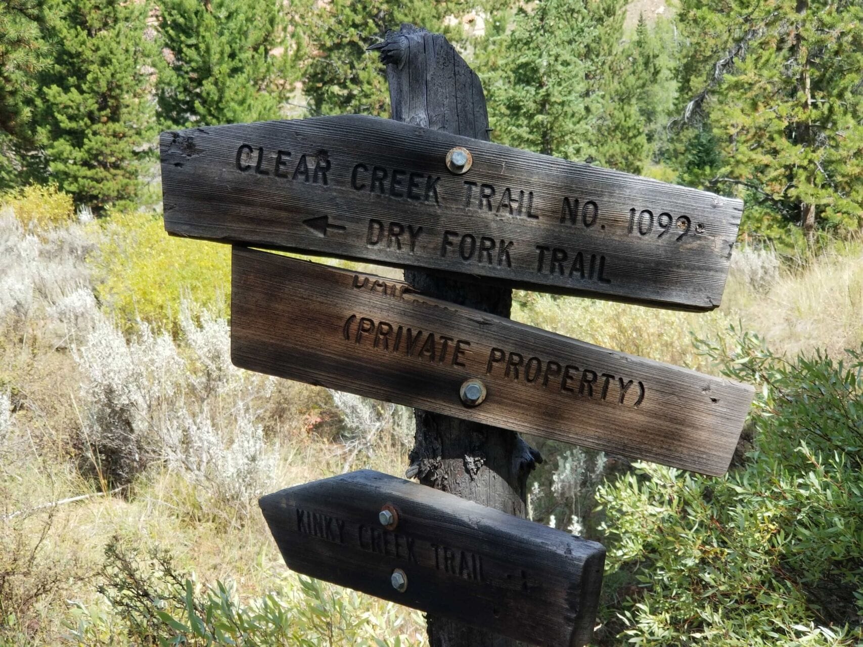


- 1. Lots of signs.
- 2. Beatriz is as big as a smurfette.
- 3. Horse crossing.
The signs were perhaps a little confusing; in fact, it might have been better if they hadn’t existed at all, but I knew the way. I asked Beatriz if she’d like me to get some water, but she said she was fine. Given that we were going up “Dry Fork,” this was a dumb decision, but I wasn’t feeling the urge to carry more on my back than I already had.


- The creek and crossing. The bridge seems new.
Across the creek, the sign options are for Dry Fork, Clear Creek, and the Gros Ventre River. We selected Dry Fork though it didn’t seem to be very highly used. The Forest Service had cut some logs out of the way, so they are giving it some upkeep. I don’t have much to say about the climb. There aren’t really any switchbacks to speak of, so the trail goes on forever through forest, never relenting in being uphill. In 0.9 miles from the bridge, you’ll climb 646 feet, and according to my GPS, lose only 3. Like I said, it’s dang consistent. I mention .9 miles, since that’s when we exited the forest and walked along a bald area.


- 1. Go right, then left.
- 2. Go uphill, not flat.
- 3. Beatriz looking at the trails.


3. Now on the first bald section, we can see the area back towards the first picture.
We then entered another couple hundred feet of forest, before finally staying along the bald ridge for about half a mile. At this point, we finished our remaining water and I was irritated that I hadn’t scooped up more. There were some nice views of the surrounding geologic features, though I didn’t stop to get any pictures with my Canon. We kept seeing what appeared to be llama tracks, though I didn’t see any human prints to accompany them.


2. The Winds also come into view.
3. Hodges Peak area, Doubtletop, Triangle, etc.

As we hiked along the ridge, Triangle Peak looked very far away. Brewster Lake is right beneath there, and I was mentally planning on where we might end up. While I thought that Brewster would be best, I was also curious about Lunch Lake, which is just 2.5 miles shy of it. We could also look down into Dry Fork. While there was no sign of water at this time of year, at least from our vantage point, there were deep cuts in the earth where water must sometimes run; it was obvious why the trail did not try to navigate there.


- 1. Old-growth and a hidden Lucas.
- 2-4. Splitting trails.
Soon we re-entered the forest and came across a massive, downed old-growth tree, which we got pictures with. From there we tromped uphill until we reached a branching cutoff to Ouzel Falls. This was at mile 3.33 on my GPS. The sign said that Lunch Lake was only 2 miles, so it wasn’t too far. I should also mention that we came across the sign for Ouzel at 3:02, and ended up being at Lunch Lake at 3:39, which was a good clip….but again, the GPS said it was only 1.39 miles, so that’s quite doable! From the sign, it’s effectively all downhill to the lake, since you’ve climbed up to 9269′ (+1279/-598) and are marching to Lunch, which is at 9197′.


The trek from the sign to Lunch Lake was quick, as I said, and we saw the dry river up close. Reaching the lake there were a couple of areas where water flowed in from the hillside, but it looked like there was otherwise no creek flowing between Brewster and Lunch at this time of year. Since it was only 3:39, I wanted to push on, but I noticed that little Beatriz was lagging behind a bit. As we left the trail and navigated the rocky shoreline toward a pretty area of sandy, crescent beach on the far side of the lake, I noticed that she had sat down to take a rest. This was my sign that we’d just have to camp here. Given that the next day would be the day we had to crest Big Balls and go off-trail for many miles, I wanted her to be fresh.


- 1. Walking along the side of the lake.
- 2. Elk tracks.
- 3. Well, time to stop soon it looks like.
I waited for her to catch up and we went to the shoreline with the beach, which is exposed in the late season, given the very low water levels. No one was around at all, nor had we seen anyone. It seemed that it would be fine to camp closer to the water (I hate needles and dirt), but Beatriz is the type who likes to be hidden in the trees, so I cleared out an area for the camp in the forest.

There is always a fine line for me between feeling resentful of company which doesn’t help with tent setup and such, and exasperation at my setup order being screwed up. Since our last trip, I had decided that I would not really teach Beatriz my setup routine, and I think she was happier to just wander around doing her own thing while I got everything ready for the evening. (The next day, she was very active in helping do different things, and I LOVED that.) For this night, I didn’t want to explain things, so I put on a podcast from Judge John Hodgman and got things going myself.


- 1. No, we weren’t running around naked.
- 2. Getting food ready.
I think that Judge John Hodgman is pretty funny, although it’s gotten too woke for me these days. I put on my favorite two episodes: Hors d’oeuvres in the Court, which is about a father who bribes his children to eat, and then suckers them out of the money, and The Girlfriend and the Grasshopper, which is about very bad girlfriends who hide food, including “pizza crumb” (which is neither pizza nor crumb) from their boyfriends. While Beatriz had some comments on these, she found them petty and stupid. (That is why they are funny.) I played some of my music, but she also wasn’t a fan of that. Thankfully I had my own earbuds, and so was able to intermittently just tune in to my own pleasures.

Getting water was almost impossible due to the extreme number of amphipods in the lake. There were no fish at all, so the crustaceans were going wild. I’d had the same problem at Dale Lake near Shannon Pass and Bewmark Lake near Kagevah Pass. As I’d brought some polartech thermal underwear, I tried to use them to strain out the amphipods. That didn’t work. Finally, I used them as an inline filter on my Sawyer, which worked perfectly. I was pretty surprised! It was really the largest number of them that I’d ever seen; they clouded the water. Yuck.


Dinner was Mac n Cheese for Beatriz and DELICIOUS Chicken n’ Dumplings for me. I let Beatriz try mine, and she absolutely hated them. Why, Beatriz? Why? Both of us partook of Dark Chocolate Cheesecake. The macaroni was fine, while the cheesecake was really more like chocolate pudding; I don’t think that we shared that much mucus, so I have no rating for any spit swapping. It tasted ok. We found the remnants of an old fire, and Beatriz, unlike myself, likes fires, so I got one going. REALLY going. We’d brought some sort of beverage (and, as it turns out, whole apples and stuff…I was not paying too much attention to what was going in my pack 😛 ) which I think was called Southern Comfort. It tasted very sweet and was nice to have a couple of sips of, though it made me miss the Coca Cola that I packed in on my trip to Bomber Mountain.
We cleaned up separately, with Beatriz choosing to do that in the tent, while I did it outside, butt-naked by the fire. I’ve NEVER hiked with a woman who wants to clean outside; they all prefer to be in the tent. I’m just the opposite and hate being constricted in the tent while trying to clean. I much prefer the nudism that the great outdoors allows.

By 10PM we were snuggled into our beds, both on Big Agnes pads at least 3.5 inches thick. I used the Big Agnes Q-Core SLX and Beatriz used the Big Agnes Air Core Ultra; she also had the folding Thermarest pad called the Z-Lite Sol, while I had the rolling one called the Ridgerest SolLite, both of which provide extra warmth. In addition, I let her use a dri-down sleeping bag, as well as the aforementioned (way up in this puppy) Wind Hard quilt. I suppose that I should mention that the Air Core Ultra is 3.5/3.25 inches thick and non-insulated, while the Q-Core SLX is 4.25 inches thick and lightly insulated. I don’t really like the side rails on the Air Core Ultra, but everyone I’ve let use it prefers them, as did Beatriz. They do help you maintain positioning, but I feel like they constrict my movement.
In the middle of the night we heard something stomping around. Beatriz wondered what it was, but I just yelled for it to get lost. We went back to sleep. It was a calm, crisp night, and I slept very well. Beatriz is a very quiet sleeper, too, which I was thankful for. I don’t believe that I am. 😛
Day 1 totals: 5.42 miles, +1501/-875. Elevation: 8201, 8298, 9269 min/avg/max. Started at 12:45 PM, ended at 4:15PM.
⤑Day 2: Lunch Lake to Shoal Lake via Big Balls of Cowtown Trail
We slept in but were on the trail by 10:30ish. Beatriz likes to eat in the morning, which isn’t something that I care for at all, as it just leaves me hungry throughout the day. She did her thing while I packed and checked out the lake, where I found fresh elk tracks. That explained the sounds during the night! Then we headed west, out of the trees and along the limestone flats, which were covered with bits of grass and brush. We could have returned to the trail, but when we had last seen it, it had been going sharply uphill. Based on satellite imagery that I looked at later on, the trail goes steeply uphill but splits off, and in fact ran only about 20 feet from us along the shoreline for some time, before tacking along the far edge of the limestone flats; both of those trails later meet back up.


We knew none of this, but it’s not like you can really get lost, so we walked .8 miles and then came upon the path again rather naturally; suddenly there were footprints. That was odd. We’d gone the whole hike up and seen no signs of other people, so where had these footprints come from?
We followed the trail from that point, and it led to some ponds which had tadpoles (why at this time of year?) and then headed more steeply uphill. Like the section between Ouzel Falls sign and Lunch Lake, this section between Lunch and Brewster seemed to take a ton of time, though in reality it was quick.

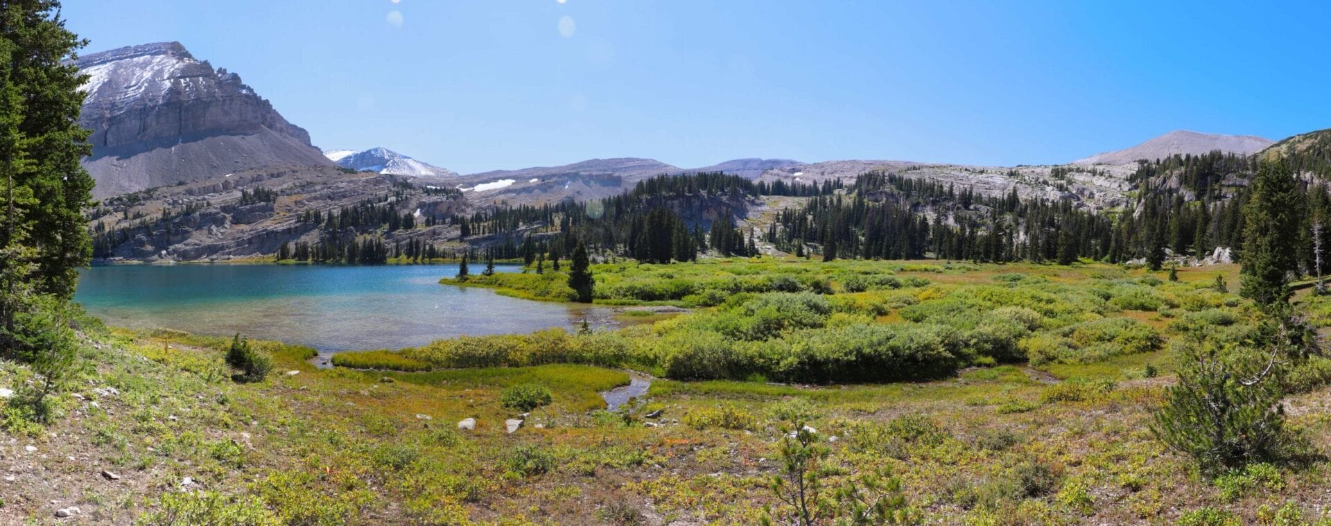
Just a mile before reaching the lake, you’ll be below a lip-like ridge that surrounds the area, and from there the uphill climb is a little steeper. We saw a bald eagle as we climbed, which was a good sign for fishing potential! At 12:15, under two hours from leaving Lunch Lake, we got our first view of Brewster Lake, situated around 9,760 feet.


Man, Brewster is a total gem. The waters are a gorgeous turquoise, there’re level, green areas to camp on all around, and Triangle Peak looms above it, riddled with caves. The limestone geology remains fascinating. In the distance to the west, one can see the lip of the Gros Ventre Range, scalloped and beautiful. This is probably the prettiest lake I’ve ever seen.


We stopped at the lake for water and to let me fish while Beatriz snacked around a bit. It was a tad windy to fly fish from our direction, so I didn’t catch anything. I was fascinated by the limestone slabs on the far side of the lake and I guarantee that (Lord willing) I shall return, just like MacArthur. As a sad note, it was a rotten time of day for pictures and I really regretted stopping at Lunch Lake, which is a true turd compared to Brewster.
Eventually our packs were shouldered and we continued on; a short while later, I heard some sounds and pointed out to Beatriz that there were two tents immediately ahead, right by the trail. Adjacent to the two tents were two tall, lanky guys wearing shorts. We approached them to be friendly, and the darker-headed one (we’ll call him Jerry) said,
“Beatriz! How are you doing?”
As it turns out, Beatriz knew “Jerry” from Jackson. Jerry is fairly wealthy thanks to relatives, so he doesn’t have to work. From what I gathered, he has combined Macaulay Culkin’s life of indolent leisure with Joe Rogan’s love of pot. I was introduced to his friend (we’ll call him “Dan”), who looked liked a marauding band of honeybadgers had attacked his legs, as he was a bloody mess. I asked them if they were the ones leaving the tracks, and why their tracks started in the middle of nowhere.
If you’ll recall, in the quick facts section and in the narrative, I’ve mentioned to pay attention to the trails near Clear Creek. Jerry and Dan apparently did not (despite Jerry having visited Brewster before, and despite professing it as his “fave place in the Gros”) navigate appropriately, and took Clear Creek’s drainage rather than the Dry Fork trail up the mountain. These trails are really NOTHING alike in terms of climb or look, so I don’t know how you get them confused (more than for an 1/8th of a mile), especially not as bad as Jerry and Dan did. In fact, they went all the way up to the little lake up Clear Creek before realizing that they were lost, and then “bushwhacked” in their shorts through the forest to Brewster, thus incurring great harm to their legs.
It was an odd experience. The two said that they planned to climb the mountains to the northwest, specifically Darwin Peak, as Jerry had already climbed Doubletop more to the south. (Visible in some of my pictures.) We wished them well and they took off, climbing up north and avoiding the riparian zone just beyond their camp. I couldn’t help but think that almost 2PM was an odd time to try to summit a mountain, but hey, grown adults! Oh, and I forgot to mention as I was typing the above, but Jerry also talked with me about climbing Wind River Peak. He’d climbed it the way that I’d descended it, and found it to be just a horrific slog. I can only imagine, because just exiting that way as a misery-fest and pilgrimage of woe that I rue to this day.
Beatriz and I took more pictures, and then crossed the creek leading into the lake, and walked across the beautiful field.


From the field, I discerned a treeless ramp that we’d use in climbing to Big Balls of Cowtown Trail. Limestone is incredibly sharp and skin-teary, so I wanted to avoid any areas where either of us could have a nasty spill. The more we could ramp rather than climb, the better. I was just staggered as we crossed the northern field by all the places one could camp. Lord, you have made an awesome world. An A380 also went overhead.

Before beginning the climb, we both stopped to pee, but did so in different areas and not holding hands. I explained the challenges to Beatriz:


We walked uphill and the going was easy. There were cliffs ahead and to our right, and I wanted to find a way up them and over toward the hanging lakes/ponds which the map indicated drained into Brewster. That would be a shorter route, and it looked like sidehilling straight ahead would put us into a disastrous hellscape of sharp, limestone scree piles. We went through a last section of trees and then started climbing the small buttress, being careful not to fall on the jagged edges of sharp rocks. And man, these puppies were exceptionally sharp. No soft, blunt granite. I helped little Beatriz up a small section, and then as abruptly as it had started, we were done and walking up gentler ramps.
The unnamed Peak and Darwin Peak were on our right, with Triangle and Doubletop Peaks on our left. It was like walking through a scene from the Lord of the Rings. Staggeringly beautiful. Looking back, we could see Brewster, Lunch (barely), and the red rocks from whence we came. I pointed out the cut between Darwin Peak and the unnamed peak that we’d take as option 3; there’s a missing gendarme that one can traverse through. The talus looked doable and not too likely to slide away. (Which I had happen in Montana once quite unexpectedly. I was able to spring to a cliff ledge.)


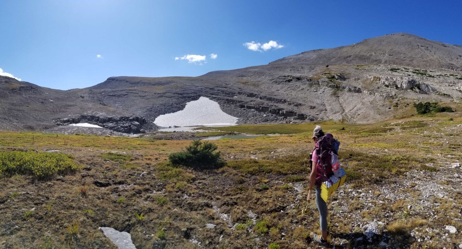
A little less than an hour after starting the climb from Brewster Lake, we’d climbed 700 feet over .83 miles, which was slow…but heck, we’d had a potty break and stops for pictures. It was then at 10,420 feet that we saw Lake 10,403. I really wanted to go check it out, but Beatriz was in no mood for extra time and distances, so we didn’t. The trials of having a companion. I doubt there are any fish, but dadgum I’d camp there. Next time, I guess. (I wish that humans lived longer so that I could see more of the mountains.)

Not stopping there, we continued the climb upward, avoiding scree as we were able. Ahead was a slope with snow, and the terrain got steeper there. South of the snow (left as heading toward it) looked the best bet, as it was ledgy to the north. I knew that we might possibly find another pond, too, so we’d get water there if we were able. Sure enough, at 10480 feet we saw the ponds. I decided right then to stick to the left side of the pond and climb the rocks at the southern edge of the snow. We walked down to the little flat, and the water flowed in a way that seemed bizarre to me. There we got water. We also kept hearing hollering and figured that it was Jerry and Dan, though we didn’t see them. Beatriz was perhaps a bit tired, so we didn’t leave until around 3:50, which was about a 35-minute break.

- The last ponds! Get water while you can!
After navigating the boulder field, we began the climb and then spotted the two guys from earlier along the mountain ridge. They’d said that they were going to Darwin Peak, so I wasn’t sure why they were there. It wasn’t Darwin Peak, and as I’ve mentioned before, the gap in the mountains made them entirely distinct and non-traversable contiguously.


Beatriz seemed to have a second wind and wound up ahead of me. I told her that we’d aim for the low spot, and then tack right toward the top. I had only a general idea of where the “Big Balls” trail might be located, so I’d have to do some exploration. Soon the Wind River Range began to pop into view to the east, and the going became much grassier and of a less steep ascent. It looked like we’d also avoid having to cross any snow, which was a blessing.

At 4:09, less than two hours after starting the climb (and in spite of the long rest break), we were along the line of cliffs, seemingly impenetrable. The view was out of this world. Words can’t describe how vast it seemed; none of the pictures that I’d seen did it justice. We stopped for pictures and looked at the cliffs. It seemed to be a 150-200′ fall all the way around. To the far east was an area that could possibly be traversed, with a lot of elevation gain and loss, but it looked sketchy. I began to question how hard it would be to find Big Balls.


- 1. Yikes, don’t fall, Eric! The horizontal ledge was going to become a backup plan if things went awry.
- 2. That lake I would have liked to have camped at.
- 3. So pretty.
- 4. Little Ms. Beatriz!
We were committed, so we tacked right and uphill, climbing another 200 feet to 11,134′, which would be our highest elevation. To the west we saw Black Peak, with the Tetons rising beyond it. I’ve never seen the Tetons look more amazing than that; it’s a view of them that almost no one will ever see. To the south and west we saw the Wyoming Range, stretching ruggedly into infinity, and to the south, the cliffs plunged down to a vast, hanging field, which had at its far end lakes, and then fell off the face of the earth to forests below; beyond even that were more mountains and then interminable plains.
Immediately southwest was Palmer Peak, which I took pictures of. One of my ex-girlfriends carried the same name (last name), though her hobbies consisted of watching Friends and quilting, and nothing beyond that, so none of this would have been any interest to her at all. Continuing the panorama was the Wind River Range, blocked from view partially by Doubletop and Triange Peak. I told Beatriz that I’d put my pack down and search for the “pass,” which took me about 5 minutes to find. It looked quite horrifically steep, with falls being incapacitating at the very least, but I figured that there might be another way that I hadn’t found. Since I’d discovered one doable way down, I was happy enough. At the worst, I’d go down with my pack, then drop it off, help Beatriz down, and then return for her pack.
As an amusing sidebar, I got cell service here, and so checked the weather to save data on my SATCOM. As I was doing so, I got a message from my buddy Allen Jones, aka Jonesy/AJ, asking why I blocked him on FB? I assured him that I hadn’t blocked him, but had simply deactivated my account. I’m not sure that he believed me, but I opened my account back up. He wished to show work friends of his all of the places I’ve been and the pictures that I have on my FB. How cool. Regardless, I mostly keep off facebook, as being on it leads me to be very depressed about my own life, reminding me that no, I do not own a Tesla. Truly tragic stuff. I’m also much more productive when I’m not on it or other social media.


We took a bunch of pictures and then heard Jerry and Dan. They came walking down the hill and asked us where their camp was, as they were lost. They also explained that they couldn’t find Darwin Peak.
To recap: they got lost going to a place one of them had been before, they got lost going to a mountain they were camping under, and then they got lost trying to leave a different mountain to make it back to their camp. To top it off, I noted a beautiful lake in the woods to the N-NW, and they thought that the lake was perhaps Chateau Lake. It’s not; Chateau is probably a full day’s walk away, in fact. This unnamed lake, OTOH, was lake 10,101 (or thereabouts), and I put it in my mental register of reasons to visit again. While it probably wouldn’t have fish, it would still be a very beautiful place to camp.


Dan’s legs were even more beaten up by this point. He commented that he was “very weak,” and had always had “a very weak body,” which is an odd comment from a male. He then sat down and pulled out a bong, asking me if I’d like to smoke some marijuana with him. The reason for their confusion was quite apparent. I declined the kindness offered, but did take pictures of the two of them, and them and Beatriz. Peering to the north, the way down between the unnamed peak and Darwin, it became apparent, but it would be a nasty endeavor with rock fields that would slow one to a crawl.


Jerry and Dan headed off at 5:05 to find their camp. I told them how to get there and hoped that they’d make it. They were very friendly tokers. I then led Beatriz to the slot I’d found; blessedly, I went a little further south and found the ACTUAL slot. Well, I guess it is. There wasn’t a sign saying “Big Balls of Cowtown Trail,” as I’d read that there might be, nor any signs of humans having used the area. The little pass was mostly very steep, loose rock that you had to be careful on; that lasted for about 40 feet, after which it was steep, loose talus. We found an incredible rock wall of crystals. I got a number of pictures and looked at the base of the cliff face, which the crystals were carpeting, for one which was liberated. Thankfully I managed to snap one, and we continued on, heading right and to the west.


- In case you want to see where Big Balls of Cowtown is…now you know.
As we descended, the walking became mostly gravels and flatstones with tufts of grass. Intermittent washes tear the landscape apart, as there’s little to prevent springtime erosion. Our route-finding took us down one steep overlook, and then over to the west, where we climbed upward (rather than traversing the flats), hoping for a direct course toward Shoal Lake. If we managed it correctly, we’d take the gap near Steamboat Peak to save miles, if it looked ok; the climb up there was about 200 feet.


It was getting later than I’d have liked, and Beatriz said her ankles felt weak. We decided to avoid climbing off-trail, and to avoid side-hilling, so we headed for Shoal Creek trail, keeping to a contour line as much as possible. We crossed a couple of creeks, saw Palmer Peak from a different view, and eventually saw Sportsman’s Ridge, too, which looks incredible. Far beyond it is North Breccia Cliffs and the area near Dunoir (duh-nor) VOR; aircraft utilizing runway 19 into Jackson Hole airport typically fly an arc into the “hole” over that area.


Outfitters were in the area so I was reminded of my buddy Wayne. Despite seeing their little, canvas tent about 1,300 feet away, we didn’t see them, and we kept contouring around until we came across a little pond which we had to skirt. The sun then started to get in our eyes. It would be dark soon, and we needed to hurry, but the Lord sure made it beautiful.


At 7 PM we were “around the bend” and tracking parallel to Shoal Creek Trail. Another pond came into view, and we got a few pictures. Beyond it only a couple of minutes walk the Shoal Creek Canyon came into view. A small pond was below, which I told Beatriz was Shoal Lake. She was not very happy with it, and so I quit teasing her and let her know that Shoal Lake was hidden below that. We walked around the eastern side of the lake and then looked over the edge to Shoal Lake itself; it seemed best to head over to the actual trail and take it down, which we did. I lost my footing and fell hard on my side, but wasn’t really damaged by it, other than being a little scraped up. We decided to stop and take pictures of Beatriz’s glasses, which have a custom retention strap made by a local artist in Jackson. Beyond the glasses, the SW edge of the lake looked like the best place to camp. There were no people around, and the fish were going crazy.


We arrived at the lake around 7:40 and picked an outfitter area to put up the tent. It had a well-built fire ring and places to sit, but was closer to the water than I typically want to be. Given the bowl that it sits in, there aren’t many options as far as places to pack it, and it was getting quite dark, so the decision was basically made for us. I fished briefly to great success; we considered cooking a fish for Beatriz, since she thought that they looked very tasty, but we were already carrying excess food. Maybe next time. While I was fishing for all the cutthroats and getting firewood (there was very little), she went to town on camp setup—color me impressed!

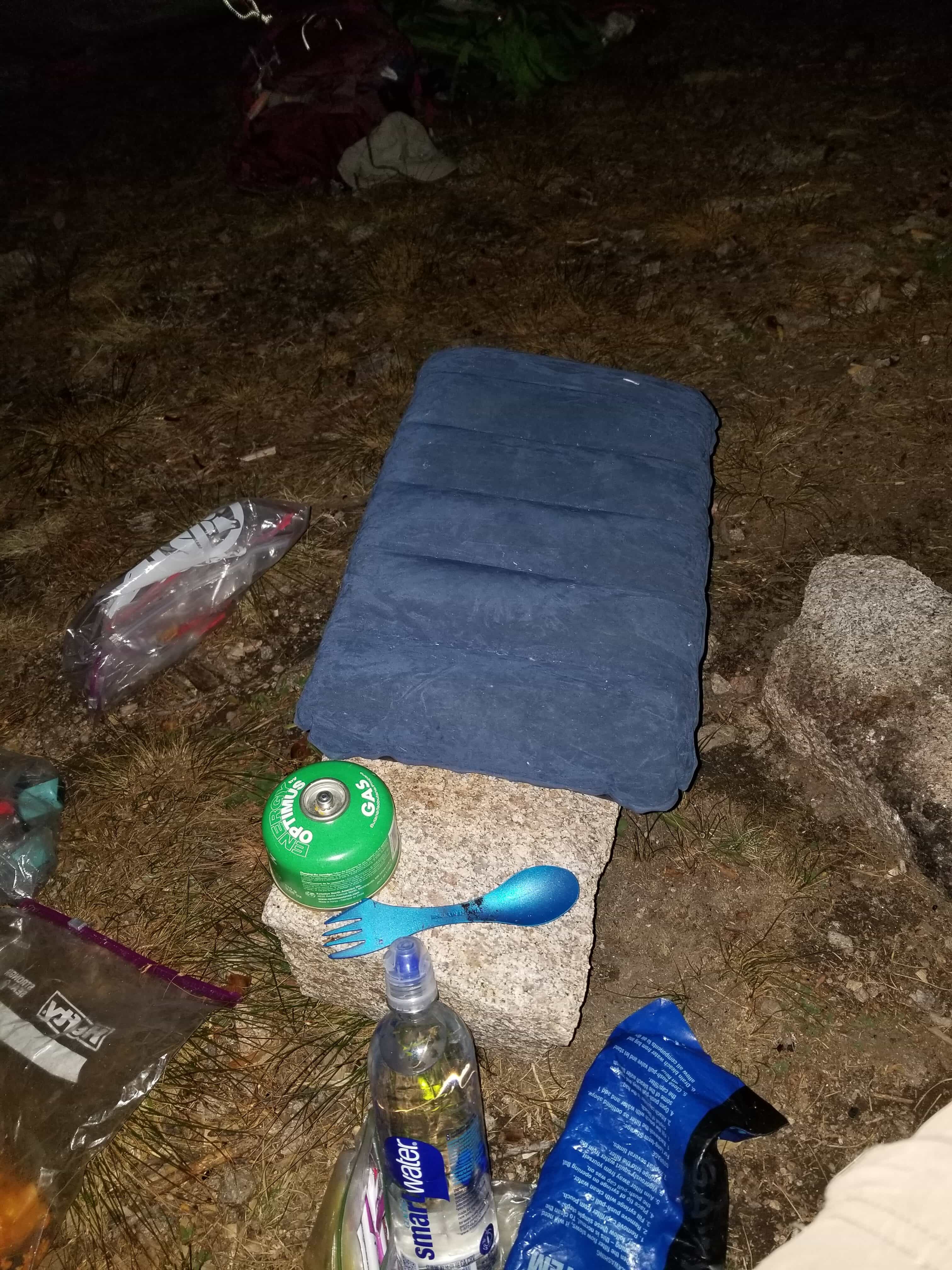


For dinner I had pasta, and I inflated my butt pillow for Beatriz to use. We chatted and listened to music until the full moon rose over the mountains, and then clambered into bed around 11:30. I was very impressed with Beatriz! Not her ability to clamber into bed, but rather her ability to crush some miles and vertical terrain, and her willingness to set up camp while I fished. She was a bit distraught at how many miles we were covering, since she thought that the total would be 15, but she had held up very well.
Day 2 totals: 8.71 miles, +2579/-2003. Elevation: 9204, 10088, 11134 min, avg, max. Started at 10:30AM, stopped at 7:40PM.
⤑Day 3: Shoal Lake to Shoal Falls TH
We slept in until 0800, and then Beatriz rolled out of bed and got busy doing private things. It was a gorgeous, clear morning. After a bit I got out, used the restroom, and packed up. I also went and climbed the hill behind our tent to look around and get pictures. It was a different view in the sunlight!


By 0930 we were walking out. The Shoal Lake Trail’s a bit boring compared to the rest of the trek. We saw plenty of places to camp, but none had anything to do; they were just boring flat spots in the canyon. Half a mile and 400 feet below the lake is the creek, which you’ll cross. You’ll cross it again a quarter of a mile later, so if you suddenly get thirsty, God’s got you covered. If that still doesn’t suit you, 800 feet later you’re at another stream, and this one with a marsh—we picked our way through it to the far side, and then climbed the hill. The mountains here are spectacular and reminded me of Togwotee Pass.


3000 feet beyond that, we were at another stream, and this one went…well, into a cave, which then went underground. It was a steep descent, but I checked the cave out.
Past the cave you’ll lose almost 1000 feet in a mile, and I was reminded of Glacier Park. On the far side of the canyon were waterfalls, while we walked down a grassy, steep hill for what seemed like ages, and then entered into lush forests for about a thousand feet. Coming out of the forest, we were at Shoal Creek again, here much bigger and swifter. I crossed and numbed my feet, and told Beatriz that I’d find her a crossing stick, as the rocks were very slippery. I found a piece of tree to break off for her, but she was already done. Tough woman.


After the creek, we were effectively in the burn for the rest of the trip. We did find some late season berries—raspberries and redcaps—and ate them. The latter is scientifically named rubus parviflorus, and more commonly called thimbleberries, though I grew up with them being called Devil’s thumbs and redcaps. They tend not to hold together very well, but I like them, and they’re like a pasty raspberry.
I pointed out to Beatriz roughly where our vehicle would be; we had quite the ways to go. We elected to not bother with Shoal Falls which was both out of the way and boring. It was incredible, though, seeing the place burned. I’d last visited prior to the burn, in November. Now it was post-burn in September. Much of the vegetation was already dying and the sounds of fall were loud in our ears—the shaking of dry husks in the crisp breeze, and the intermittent cacophony of raucous gray jays. Even in this ugly area, Beatriz kept saying, “Thank you, Lord,” which struck me as so appropriate—I need to practice that more often! God bless her!


At 8050 feet, the trail splits and goes on to the parking lot, or over the hill to the right towards Granite Hot Springs. I’ve been on it a bit toward Granite, but this time we kept pressing ahead toward Beatriz’s vehicle. At 7700 feet, you’ll encounter another junction; going left leads you over the hill and to a park, but outside of hunting, there’s never any reason to take that trail. (I think that it’s called Tincan Park, or something of that nature, but I don’t have my map as I type this.) Regardless, keep right and cross the creek, and then follow the trail on out. The walking seemed to take forever and was much longer than I recall it being with Dale. The beaver lodges along the creek were also gone; maybe the fire killed them.


Reaching the end of one open area of riparian zone, I pointed out to Beatriz where the road supposedly led if one followed it, and how my map from the 50s showed a trailhead there. I wonder why it was abandoned. It wasn’t worth crossing the brush and creek to hunt for what might even not exist anymore, but I did keep checking my map to see how long it would be. 21 miles into the hike exactly, we reached a hillside where we could see the cars…except they were blocked by a forested knoll. 0.9 miles later, the trail split, and we headed left. I didn’t want to take off my shoes, so I had Beatriz follow me upstream; we found downed logs to precariously cross, as I’d thought we might.
Minutes later, we reached the vehicle and 1:58PM and packed up. Oddly, a couple of FWP people came riding by and chatted with us, then asked us if we’d fished. I was honest, and so the young one quickly jumped on me about my fishing license. I had to dig it out.


I got my license out (in my hip pocket in my bag, though also on my phone), and asked him for info on the lakes, especially lake 10101 and Brewster. The young guy had no clue; he was an utter, oblivious buffoon. His older partner, who looked like Sam Elliott, was more familiar, but also didn’t have any information. These were the same two we’d seen at the trailhead (also in a big, canvas tent with stove) when we parked, so I thought that they might know more.


The old guy asked us where we’d come from, and I told him. His response was fairly close to, “You came over near Darwin? There’s not even a trail…I didn’t know you could make it over those cliffs.” His young partner asked about the trail, and the old guy told him that it was basically just bushwhacking. Not incorrect.
We headed out in Beatriz’s vehicle and she scraped the bottom hardcore. I felt bad, but on the other hand, she’d made fun of my driving on the way up, so I guess we know who’s the better driver. 😉
During the drive, I realized that Beatriz can take corners in her large vehicle at 400% of the speed that I guessed was possible; I thought we might die. We arrived at 4:47, meaning that Beatriz would be home around 7. I’d get in around 8:45. We were a bit worried, as Jerry’s car was still there, and we hoped that they’d made it out ok.


On the way out I took pictures of a small airplane at the Kinky Creek Divide airport, as well as a new STOL strip that had been installed closer to the Green River Lakes road. Beatriz, meanwhile, decided to go find “Mosquito Lake,” since some friends of hers had said that it was a nice place to camp. With a name like that, I’d not be busy looking for it, but she was curious!
Day 3 totals: 7.8 miles, +607/-2970. Elevation: 7410, 8367, 9843 min/avg/max. Start time: 9:30AM End time: 1:58PM
➤Conclusion and Rating
Beatriz and I are very different people! She’s an amazing, pretty, sporty little woman who was a blessing to hike with, and not just because we needed two vehicles! She pumped out more miles than she expected and didn’t complain (often). Most importantly, she was able to no-kidding tolerate me not just for minutes, not just for hours, but for DAYS straight, and with no one to rescue her. I rate her 5 stars!
The hike itself also gets a rare 5-star rating from me. I could spend weeks exploring all the nooks and crannies of this range. The geology was fascinating, the fishing good, the crowds non-existent, and the landscape fantastic in a way that I’d never experienced before. It was a blessing beyond words.
- My scientific rating system. I loved this hike.
- Beauty. The range of geology, the glistening lakes, and the fishing make this hike a blast. You’ll get views of the Tetons that few people on this planet have seen.
- Camping spots. Plentiful.
- Crowds. We saw two people.
- Difficulty. Overall, this hike was easy for me, even carrying what was effectively a double-pack. I also added extra weight for creature comforts for Beatriz. For a person who hikes a bit, it’s no big deal. Strenuous, but not hard. Do use care in pathfinding.
- Fishing. I caught a ton of fish!
- History. Nope.


7 thoughts on “Review: Brewster, Lunch, & Shoal Lakes via Big Balls of Cowtown Trail”
Did a backpack trip in the Gros Ventre in July, and had seen your trip report which is probably the best I have seen that shows how to get from Brewster over to Shoal Lake. My sons and I started at Granite Creek trailhead to shoal falls (camped), lost the trail to shoal lake, later found it then camped at shoal lake. We had intended to go from Shoal lake to Brewster but got up very late and did not make it over there, mainly because I was too old and tired. We then drove over to Kinky Creek trailhead with the intent of hiking to brewster but took the wrong trail (Dry Fork Clear Creek), got lost (common theme), eventually found the correct trail and end up stopping at Lunch Lake. It’s a beautiful area without many people. None of it is boring, it’s all great. Shoal falls is worth the trip, only takes about 10 minutes to get to the base of the falls, definitely worth it, particularly if you are already there. Thanks for the write up,as it’s hard to find much info on the area as everyone seems to go to the Tetons or the winds. Gros Ventre seems much wilder to me.
Steve, I am glad you enjoyed the hike. I bet it’s pretty hot during July! We were blessed with it being cold at times, though there were also points where it was too hot for our liking. I’m hoping to go back this summer and maybe do a loop out through the Crystal Creek area.
I did Granite Creek to MacLeod this summer, which was pretty miserable as I was awfully sick it was pretty dang hot and smoky. I imagine that the Granite Creek trail to Shoal must be pretty difficult to pick at times these days, given the fire and the underbrush that grows there now.
Sorry to hear that you didn’t make it up and over! Like Elkhart/Green River Lakes, I think that one direction is probably quite a bit more demoralizing than the other. I’ve certainly had my share of re-routes while hiking, though sometimes you end up coming across something that you like better. (For example, I would never have made it to Bomber and Mile Long Lake without coming across an impasse on a hike, which meant that I also ended up doing another hike where I found a memorial plaque way out in the middle of nowhere, and off trail!)
I really do like that no one goes to the Gros Ventre, and I’m really very humbled by your response. With no advertising and some purposeful de-ranking, I don’t get many hit on my ‘lil ‘ol blog, so when I do, and it’s such a wonderful remark, my day is really made!
GB,
Luke
Enjoyed your write up. Thanks.
Hi Bill,
Very few people visit this page, so I’m glad that you did, and that it was helpful. Hope you are blessed.
Luke
You sound like an arrogant asshole. And if you want special places like this to remain special so others can enjoy the experience that you did, then stop posting a thousand photos and telling everyone about it. You are literally the reason our backcountry is being overrun by idiots like yourself.
This is likely the most notable comment yet. (Not that I get many, or many visitors to my e-scrapbook.)
You may enjoy the following:
https://www.instagram.com/
https://www.mayoclinic.org/healthy-lifestyle/adult-health/in-depth/anger-management/art-20045434
I use a bidet if that makes it better?