This hike covered both the Cirque of the Towers and Temple Basin. Which do you think is a better place to visit?
➤Quick Facts
Information at a Glance
- Time of Year: 31 Aug-2 Sep
- Notable Features: Big Sandy Lake, Big Sandy River, Lost Creek, North Creek, North Lake, Arrowhead Lake, Cirque of the Towers, Jackass Pass, Rapid Creek, Rapid Lake, Miller Lake, Temple Lake, Deep Lake, Clear Lake, Diamond Lake, V Lake, Meeks Lake
- Total Miles: ~23 miles
- Elevation Gain/Loss: +/-4365′
- Elevation Min, Avg, Max: 9094, 9831, 10,753′
- General Route: Big Sandy Trailhead, Big Sandy Trail 099, Jackass Pass, Big Sandy Lake Camp, Rapid Creek Trail, Little Sandy Trail / Clear Lake Trail, Trail 099, V Lake Trail 100, Continental Divide Trail 096, Big Sandy Trail 099, Trailhead
- GPS Track Download Sign up for free. Download the track to your phone of Google Earth with the “download” option on the top left.
- Housekeeping: Feel free to contact me for better pictures. These are compressed and then delivered via a CDN. (Low quality.) 🙂
Interactive Map (Click or Tap)
Elevation Profile (Click or Tap)
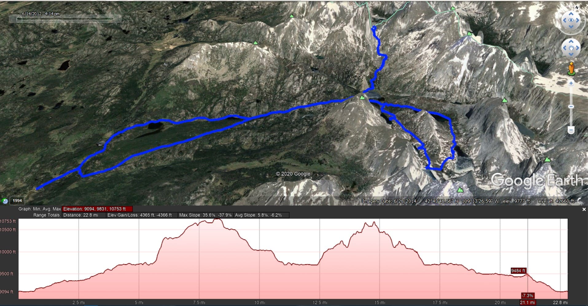
Note: The humps above are flipped around from how I took the trip, with Temple being the first and Jackass being the second. I was recording separate tracks with endpoints at each big stop and accidentally flipped the routes around when I put them back together.
⤷Introduction
Although the Cirque of the Towers is popular—too popular if you ask me—I prefer nearby Temple Basin. My sister didn’t feel like hiking with me, but my mom agreed to tag along (she had always done independent business, allowing her to set her own hours) for a short trip where we’d do the Cirque and Temple.
⤑Day 1: Big Sandy Trailhead to the Cirque
The trail from Big Sandy trailhead to Big Sandy Lake is very docile. I’ve written about it when it was busy during a horrible storm, when I visited the Cirque and was the only person there, when I explored the relatively unknown Blue Lake, and when I took my dog to Black Joe. Because I’ve detailed it in so many other reviews, I’ll keep this section brief, mostly noting differences.
We arrived at the trailhead around 1115 and found it to be well populated though not packed to the brim, which is unusual for Big Sandy. The weather was rather pleasant, though a bit warm and still. I always wear long sleeves regardless, as they help me stay clear of bugs, brush, and sunburn.
The trail is very docile, passing beside the river and numerous little parks before climbing into continuous forests. We arrived at Big Sandy and found a free campsite near the outlet, which is rather the enviable spot to camp. Outfitters had left some wood, too. Quite unusually, no one else was in the area, nor would anyone end up showing up for our duration. What a blessing.


- Trail up and camping spot!
After about an hour of setting up and eating some Reeses Pieces (note: my proofreader commented, “that must’ve been a lot of Reeses Pieces”). I took my pack and we headed along the west side of the lake toward Jackass Pass. I’ve described the pass before, too. Strangely, we didn’t see anyone until reaching North Lake, though usually the area is packed. Above North Lake we took the climber’s path to the west of Arrowhead Lake rather than climbing up Jackass, which continues to the east. The climber’s path goes through a boulderfield and is easy to navigate, but I don’t recommend it during times of thermal flux, as I’ve watched a 20-ft section calve off, and have been almost hit by calving boulders twice.


- Second row is north lake, beyond which is the climber’s trail and Arrowhead Lake.
We crested the hill and had views of the Cirque at about 6:30, which meant that we had time to explore a bit. We could see a lot of tents in the valley, so we decided to just enjoy the evening views rather than going and mixing it up with strangers, who I expect were all very kind and affable.


- Cirque of the Towers.
After an hour we started to make our way back to camp, again choosing the climber’s path. Somehow my water filter got lost during this, but we had two, so it wasn’t the end of the world…still, I hate losing $30. At the intersection of the Jackass trails we met a lone, young hiker who asked us how much farther it was to the Cirque, and if we’d used the climber’s trail, which his friends had told him about. He was pretty nice and we chatted a bit before heading back to camp. Although we saw plenty of tents as the sun set, we didn’t see much in the way of human trail presence. Unusual!


- Big Sandy Lake. Sorry for the horrible phone photos.
The night was warm for the time of the year, but we still slept well!
Day 1: ~10.5 miles, +2525/-1915′, 9094′ min, 10684′ max
⤑Day 2: Temple Basin Loop


Our second day started off with breakfast for us both, which is unusual, but we both wanted food. As it was a short hike, we’d brought some MREs in addition to the dehydrated meals. In the military I’d developed a fondness for the chicken and feta meal, so I had that and we shared some hot, spiced apples! Yum!
We set off for the Temple loop at 1000, choosing to cross Big Sandy outlet (sometimes easy to cross the rocks, and sometimes the rocks aren’t passable, and the water is too deep) and utilize the Schiestler Peak side of the lake. The walk is pretty easy on that side, with only one section of kinda forested/cliffy area to navigate. At the inlet creek with a small beach, we tacked right and east through the woods, arriving at Rapid Creek, which had logs to help us cross it. It also had a ton of brook trout, though we didn’t fish. After crossing the creek we hit a trail and went right. This trail, though unnamed and not on maps, takes one up to Rapid Lake and makes the Temple Loop. It’s fairly well-worn.
The use trail took us into dry forests and climbed the hill near Rapid Creek, though it didn’t get super-close. We clambered down into the chute area of the creek once to get water, and as we made our way back up the rocky and dirt-exposed banks of the creek, we both wondered if there would be fish in the lakes above. After eating some wortleberries and noting that the views during the climb weren’t the best, we continued the ascent, finally breaking out into a very long, sloped field in which the trail was much less distinct, mostly being bent grasses. On the right of the field and slightly ahead was a long stand of trees, in which Rapid Lake was concealed.


- Big Sandy, the trail approaching Rapid Lake, and Rapid Lake.
We stopped and fished for some time at Rapid Lake, but had little success. The sun was a bit hot, but as clouds built up secondary to diurnal heating, we left the lake and headed uptrail towards Miller Lake. The grade was very gentle, and the expansive field before us seemed as a giant tabletop, but one where the table had two legs that were shorter than the rest. Behind us, the views became better as we gained elevation. Around Miller Lake we ran into an old couple from New Zealand who were a total blast to talk to and loved the United States! God bless them!


- Leaving Rapid Lake, exploring Miller Lake, and then leaving Miller Lake. Notice the New Zealanders!
A brief stop at Miller Lake was a pain as it’s ensconced in boulders somewhat like Lake Donna beneath Pronghorn Peak. For that reason we spent little time there and moved uphill to Temple Lake. The outlet was shallow and wide with plenty of rocks, so we made our way along them and commenced with fishing. I caught a number of brook trout as brief rains passed through. My mom also had a great deal of success!


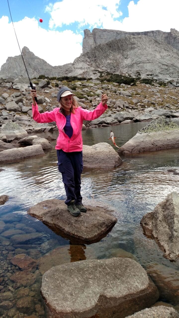


- Approaching Temple Lake, fishing there, and then leaving it!
Given that the clouds were building, we departed around 5 and made our way up and over the hill toward Deep Lake. At the top of the hill we stopped to ponder how it would be to climb East Temple Peak; we both have friends who have done it, though neither of us has as of 2020! There wasn’t time, so we found the Little Sandy Trail and hoofed it down to Deep Lake, which is my favorite overnighter in the range. Truly a marvel, and when the clouds swamp it, the peak looks like a boat crashing through waves.


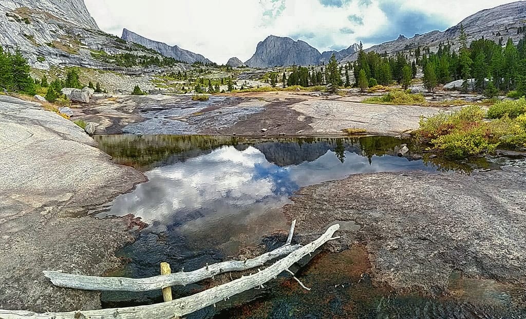
- Descending from the ridge down to Deep Lake, and then walking down the awesome granite ramps to Clear Lake. There are fish in the creek.
The walk back to Big Sandy takes the solid, granite chute down to Clear Lake, with spectacular views of the smooth, curvaceous sides of Haystack Mountain. From there it becomes a proper trail, skirting the north side of the lake before entering into forests and descending down to the Big Sandy Area. We made excellent time and were soon crossing Rapid Creek and heading back to camp.

- Flowers and Clear Lake with storm building.
That night there were brief sprinkles as we sat by the fire, but only enough to make the day more memorable. Temple is my favorite intro hike for anyone, and it had been an awesome, leisurely pace for us. I think that the lack of crowds, the numerous lakes, the staggering granite waterway, and the soaring majesty of East Temple Peak makes Temple Basin superior to the Cirque of the Towers.


Day 2: ~6.9 miles, +/-1528′, 9699′ min, 10753′ max
⤑Day 3: Out via Diamond Lake and V Lake
After a refreshing sleep, we got up with the dawn and started packing our bags. Within an hour we were on the trail; we decided to see what V Lake and Diamond Lake were like, as we’d never hit them up, so we took the north trail at the intersection on the way back. Going this way only adds 1/2 mile one-way, so it’s not bad.


Diamond Lake is only 900 feet from Big Sandy Trail, so it’s easy to bag if you like adding lakes to your memories. As a lake it was very boring, though it did have a nice meadow on the north shores, with lush grass. I caught nothing, though the fishing guide for the range (which has many of the lakes that have trout listed) said that it had cutthroat in it, and that V Lake had rainbows.


- Diamond Lake. Ugly.
Given that the lake was kind of an ugly, brownish lake, we spent little time there, soon plowing back into the forest and up a slight hill before descending to a pleasant meadow which began with a stream crossing, where we got some more water. The trail goes through the meadow, but it appeared as if it might be a bit marshy, so we stuck to the trees, rejoining it at yet another stream crossing just 800 feet later.
One more section of forest then presented itself, and then we were walking down to, get this, another meadow and stream crossing. We were finally at V Lake! The trail stayed on the west side of the lake and we found its southern shore to be less marshy, so that’s where we stopped to fish and take a little break, as we had tons of daylight. We saw no fish and got no bites, so we spent less than 30 minutes there before departing. As a note, it is perhaps the most oddly shaped lake that I’ve ever seen.


- V Lake. Ugly, but check out the stud.
The trail then climbed into forest, though probably by less than 100 feet, and we were soon taking a couple of switchbacks down to Meeks Lake, which I’ve mentioned multiple times as being one of the prototypical, ugly, pothole, acidic looking lakes that might as well just wear the badge of “glorified swamp.” Bah!

- Big Sandy!
From there we crossed the creek below Meeks and were quickly back at Big Sandy Trail, reaching the vehicle less than 15 minutes later.
Day 1: ~5.35 miles, +364/-968′, 9094′ min, 9749′ max
➤Conclusion and Rating
As an intro overnight, the Temple Basin loop is probably the best in the range. As a 3-day trip, getting to add on the Cirque means that one has gotten one of the “peak Rockies” vistas in the same trip. Despite that, I don’t care for the crowds, so I don’t recommend this hike until later in the fall. Since there weren’t many people this time, she gets 5 stars!
- My scientific rating system.
- Beauty. The mountains you get to see on this puppy are just staggering. Everyone should see them.
- Camping spots. A plethora during this trip, but during peak season you might fight over them.
- Crowds. Typically this is very high-use. Like Titcomb, it might one day be a lottery.
- Difficulty. Moderate.
- Fishing. Lots!
- History. Not so much.
